
Montant total (1 article articles) :
Destination de la commande :

globe terrestre celeste (22 rťsultats)
Commentaires
Passer aux rťsultats principaux de la recherche
Filtres de recherche
Type d'article
- Tous les types de produits
- Livres (8)
- Magazines & Pťriodiques (Aucun autre rťsultat ne correspond ŗ ces critŤres)
- Bandes dessinťes (Aucun autre rťsultat ne correspond ŗ ces critŤres)
- Partitions de musique (Aucun autre rťsultat ne correspond ŗ ces critŤres)
- Art, Affiches et Gravures (7)
- Photographies (Aucun autre rťsultat ne correspond ŗ ces critŤres)
- Cartes (6)
- Manuscrits & Papiers anciens (1)
Etat En savoir plus
Reliure
- Toutes
- Couverture rigide (6)
- Couverture souple (Aucun autre rťsultat ne correspond ŗ ces critŤres)
Particularitťs
- Ed. originale (1)
- Signť (Aucun autre rťsultat ne correspond ŗ ces critŤres)
- Jaquette (Aucun autre rťsultat ne correspond ŗ ces critŤres)
- Avec images (21)
- Sans impressions ŗ la demande (19)
Langue (2)
Prix
- Tous les prix
- Moins de EUR 20 (Aucun autre rťsultat ne correspond ŗ ces critŤres)
- EUR 20 ŗ EUR 45
- Plus de EUR 45
Livraison gratuite
Pays
Evaluation du vendeur
-
Mappemonde cťleste, ou Exposition des principes astronomiques relatifs au Globe terrestre et ŗ la connoissance gťnťrale du Ciel. Application ŗ ces deux objets, de diverses notions ťlťmentaires de gťometrie, d'optique, de perspective et de calcul 1801 [Leather Bound]
Vendeur : Gyan Books Pvt. Ltd., Delhi, Inde
…valuation du vendeur 5 sur 5 ťtoiles

EUR 30,97
Autre deviseGratuit expťdition depuis Inde vers Etats-UnisQuantitť disponible : Plus de 20 disponibles
Ajouter au panier -
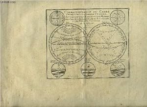
CORRESPONDANCE DU GLOBE TERRESTRE A LA SPHERE CELESTE. SITUATION DES HABITANS DU MONDE, DES CERCLES DE LONGITUDE ET DE LATITUDE, ET DES DIVERSES POSITIONS DE LA SPHERE [ATLAS]
Editť par Published by the author, Paris, 1705
Langue: franÁais
Vendeur : R. Hart Books, Ottawa, ON, Canada
…valuation du vendeur 4 sur 5 ťtoiles

Carte Edition originale
EUR 2†411,50
Autre deviseEUR 5,53 expťdition depuis Canada vers Etats-UnisQuantitť disponible : 1 disponible(s)
Ajouter au panierHardcover. Etat : Very Good. No Jacket. First Edition. An atlas comprising 19 maps (1. Des cercels de Longitude et de Latitude, et des Diverses Positions de la Sphere; 2. Carte General du Globe Terrestre et Aquatiques ou Mappemonde en deux Plans-hemisphere 1705; 3. l'Europe Dresee sur diverse Relations; 4. L'Asie Dressee Sur Divers Relations 1705; 5. L'Aftique Dressez sur les dernieres Relations; 6. L'Amerique Meridionale; 7. L'Amerique Septentrionale et les Terres Polaires Arctique; 8. La France Avec Ses Acquisitions Insqu'a l'Annee 1705; 9. Les Environs de Paris 1705); 10. Les XVII Provinces des Pais Bas Divisees 1705; 11. Les Isles Britanniques ou Sont les Royaumes D'Angleterre D'Ecosse, et D'Irleland avec les Costes Septentrionales de France et Celles de Pais Bas; 12. Suede Norvegue et Dannemarck 1705; 13. Les Estats de la Couronne de Pologne 1705; 14. L'Allemagne Divisee En Dix Cercles Dressee sur les Derniers memoires; 15. Estats du Grand Duc de Moscovie suivant les derniere relations; 16. Hongrie ou Partie Septent de la Turque en Europe; 17. L'Espagne Divisee en Galice Asturies Biscaye, Navarre, Leon Vielle et Nouvelle Castille, Arragon, Andalousie, Mursie, Valence et Catalogne avec Les Isles Majorque, Minorque et Yvica au Roy d'Espagne; Le Portugal et L'Algarve avec Roy de Portugal; 18. L'Italie Divisee en ses Pricipaux Estats; 19. Partie Mediridionale de la Turquie D'Europe ou La Grece. Each map has a written descritpion (in French). The first 2 pages are lacking the paper on the right-hand edge and have been repaired. The remainder of the maps and text are in very good original condition. A newer binding in 3/4 brown calf over brown boards, with marbled endpapers, with the bookplate of Antonio Barrette on the (blank) ffep. An excellent copy of a very scarce work.
-

Map of Globe Terrestre/Globe Celeste.
Editť par [Paris: French publisher, circa 1780]., 1780
Vendeur : Wittenborn Art Books, San Francisco, CA, Etats-Unis
…valuation du vendeur 4 sur 5 ťtoiles
Art / Affiche / Gravure
EUR 65,77
Autre deviseEUR 8,51 expťdition vers Etats-UnisQuantitť disponible : 1 disponible(s)
Ajouter au panierEtat : Good. Hand colored engraving. 21.5 x 28.5 cm. (plate). Good, sheet slightly toned, several small holes in center of image.
-

"Division du Globe Terrestre par zones corrspondant ala sphere celeste." - Terrestrial Sphere Globe World map Karte map
Editť par Paris, 1719
Langue: franÁais
Vendeur : Antiquariat Steffen VŲlkel GmbH, Seubersdorf, Allemagne
Membre d'association : ILAB VDA
…valuation du vendeur 5 sur 5 ťtoiles
Art / Affiche / Gravure
EUR 49,99
Autre deviseEUR 49 expťdition depuis Allemagne vers Etats-UnisQuantitť disponible : 1 disponible(s)
Ajouter au panierOriginal Kupferstich aus dem sehr seltenem Atlas von Chiquet. -- Bild-MaŖe: ca. 17 x 21,5 cm. -- gut erhalten. || Original engraving out of Chiquet's very rare Atlas. -- in good condition. Wir kaufen und verkaufen alte BŁcher, Handschriften, Zeichnungen, Autographen, Grafiken und Fotografien. Wir sind stets am Ankauf von kompletten Bibliotheken, Sammlungen und Nachlšssen interessiert. Sprache: FranzŲsisch Gewicht in Gramm: 10.
-
Mappemonde CŤleste, ou Exposition des principes astronomiques relatifs au Globe terrestre et ŗ la connoissance gŤnŤrale du Ciel. Application ŗ ces deux objets, de diverses notions ŤlŤmentaires de gŤomŤtrie, d'optique, de perspective et de calcul.
Editť par Durand, 1801
Vendeur : Libreria M. T. Cicerone, Roma, RM, Italie
…valuation du vendeur 5 sur 5 ťtoiles
EUR 180
Autre deviseEUR 46 expťdition depuis Italie vers Etats-UnisQuantitť disponible : 1 disponible(s)
Ajouter au panierRilegato. Etat : discreto. In 8į , p. tela no coeva, pp. VIII + 370 + 2 tavv. , piý volte ripiegate, f. t. Esemplare con barbe.
-
ATLAS PAR N.DE FER DE 1705 - 18 CARTES EN NOIR ET BLANC AVEC 18 PAGES DE TEXTES - Correspondance du globe terrestre a la sphŤre cťleste situation des habitans du monde des cercles de longitude et de latitude et des diverses positions de la sphŤre ETC.
Editť par A PARIS CHEZ L'AUTEUR DANS L'ISLE DU PALAIS A LA SPHERE ROYALE, 1705
Vendeur : Le-Livre, SABLONS, France
Membre d'association : ILAB
…valuation du vendeur 5 sur 5 ťtoiles
EUR 4†005
Autre deviseEUR 42 expťdition depuis France vers Etats-UnisQuantitť disponible : 1 disponible(s)
Ajouter au panierCouverture rigide. Etat : bon. R300113009: 1705. In-4. Cartonnť. Etat d'usage, Plats abÓmťs, Dos satisfaisant, Intťrieur frais. Atlas comportant 18 cartes en noir et blanc et 18 pages de texte (textes sur deux colonnes) - DESCRIPTIONS DES CARTES : Correspondance du globe terrestre a la sphŤre cťleste situation des habitans du monde des cercles de longitude et de latitude et des diverses positions de la sphŤre - carte gťnťrale du globe terrestre et aquatiques ou mappemonde en deux plans hťmisphere - L'Europe dressťe sur diverse relations - L'Asie dressťe sur divers relations - L'Afrique dressez sur les derniŤres relations - L'Amťrique Mťridionale - L'Amťrique septentrionale et les terres polaires artiques - La France avec des acquisitions jusqu'a l'annťe 1705 - Les environs de Paris - Les XVII Provinces des PaÔs Bas divisťes en Provinces Unies en PaÔs Bas catholiq et en PaÔs Bas FranÁois - Les Isles Britanniques ou sont les Royaumes d'Angleterre d'Escosse et d'Irlande avec les costes septentrionales de France et celles des PaÔs Bas - Suede Norvegue et Dannemarck - Allemagne divisťe en dix cercles dressťes sur les derniers memoires - Les Estats de la couronne de Pologne - Estats du Grand Duc de Moscovie suivant les derniere relations - Hongrie ou partie sepentrionale de la Turquie en Europe - L'Espagne divisťe en Galice Asturies Biscaye Navarre Leon Vielle et Nouvelle Castille Arragon Andalousie Mursi Valence et Catalogne avec les Isles Majorque Minorque et Yvica - L'Italie divisťe en ses principaux Estats - plats cartonnťs - coins frottťs - annotations sur la page de garde - 10 photos disponibles. . . A l'italienne. Classification Dewey : 840.05-XVIII Ťme siŤcle.
-

"Division du globe terrestre par zones corespondantes a la sphere celeste / Correspondance du globe terrestre avec la situation des habitans du monde" - Double hemisphere globe climatic zones / Weltkarte world map
Editť par Amsterdam c. 1740., 1740
Langue: franÁais
Vendeur : Antiquariat Steffen VŲlkel GmbH, Seubersdorf, Allemagne
Membre d'association : ILAB VDA
…valuation du vendeur 5 sur 5 ťtoiles
Carte
EUR 59,99
Autre deviseEUR 49 expťdition depuis Allemagne vers Etats-UnisQuantitť disponible : 1 disponible(s)
Ajouter au panierOriginal Kupferstich-Karte aus Hendrik de Leth's Atlas von ca. 1740. -- Blatt-MaŖe: ca. 20 x 23 cm. -- gut erhalten. || Original engraved map out of Hendrik de Leth's Atlas from around 1740. With several diagrams showing the correlation between the earth and the sky-- in good condition. Wir kaufen und verkaufen alte BŁcher, Handschriften, Zeichnungen, Autographen, Grafiken und Fotografien. Wir sind stets am Ankauf von kompletten Bibliotheken, Sammlungen und Nachlšssen interessiert. Sprache: FranzŲsisch Gewicht in Gramm: 10.
-

"Globe Terrestre. Globe Celeste" - Globe Globus world map Weltkarte Karte map
Editť par Paris, 1719
Langue: franÁais
Vendeur : Antiquariat Steffen VŲlkel GmbH, Seubersdorf, Allemagne
Membre d'association : ILAB VDA
…valuation du vendeur 5 sur 5 ťtoiles
Carte
EUR 79,99
Autre deviseEUR 49 expťdition depuis Allemagne vers Etats-UnisQuantitť disponible : 1 disponible(s)
Ajouter au panierOriginal Kupferstich aus dem sehr seltenem Atlas von Chiquet. -- Bild-MaŖe: ca. 16,5 x 21,5 cm. -- gut erhalten. || Original copper engraving out of Chiquet's very rare Atlas. -- in very good condition. Wir kaufen und verkaufen alte BŁcher, Handschriften, Zeichnungen, Autographen, Grafiken und Fotografien. Wir sind stets am Ankauf von kompletten Bibliotheken, Sammlungen und Nachlšssen interessiert. Sprache: FranzŲsisch Gewicht in Gramm: 10.
-

"Globe Terrestre / Globe Celeste" - world map Weltkugel Globus globe Sonnenfinsternis Mondfinsternis Karte map
Editť par Paris, Crepy, 1756
Langue: franÁais
Vendeur : Antiquariat Steffen VŲlkel GmbH, Seubersdorf, Allemagne
Membre d'association : ILAB VDA
…valuation du vendeur 5 sur 5 ťtoiles
Art / Affiche / Gravure
EUR 119,99
Autre deviseEUR 49 expťdition depuis Allemagne vers Etats-UnisQuantitť disponible : 1 disponible(s)
Ajouter au panierBildmaŖe: ca. 22 x 29 cm Originalteilkolorierter Kupferstich von 1756. -- gut erhalten || Original hand colored copper engraving from 1756. -- in very good condition. Wir kaufen und verkaufen alte BŁcher, Handschriften, Zeichnungen, Autographen, Grafiken und Fotografien. Wir sind stets am Ankauf von kompletten Bibliotheken, Sammlungen und Nachlšssen interessiert. Sprache: FranzŲsisch Gewicht in Gramm: 10.
-

"Globe Terrestre / Globe celeste" - World Map Globe Globus Celestial
Editť par Amsterdam c. 1740., 1740
Langue: franÁais
Vendeur : Antiquariat Steffen VŲlkel GmbH, Seubersdorf, Allemagne
Membre d'association : ILAB VDA
…valuation du vendeur 5 sur 5 ťtoiles
Carte
EUR 119,99
Autre deviseEUR 49 expťdition depuis Allemagne vers Etats-UnisQuantitť disponible : 1 disponible(s)
Ajouter au panierOriginal Kupferstich-Karte aus Hendrik de Leth's Atlas von ca. 1740. -- Blatt-MaŖe: ca. 20 x 23 cm. -- gut erhalten. || Original engraved map out of Hendrik de Leth's Atlas from around 1740. -- in good condition. Wir kaufen und verkaufen alte BŁcher, Handschriften, Zeichnungen, Autographen, Grafiken und Fotografien. Wir sind stets am Ankauf von kompletten Bibliotheken, Sammlungen und Nachlšssen interessiert. Sprache: FranzŲsisch Gewicht in Gramm: 10.
-
Globe Terrestre - Globe Celeste
Editť par Globo terrestre e celeste
Vendeur : Sergio Trippini, Gavirate, VA, Italie
Membre d'association : ALAI ILAB
…valuation du vendeur 4 sur 5 ťtoiles
EUR 150
Autre deviseEUR 46 expťdition depuis Italie vers Etats-UnisQuantitť disponible : 1 disponible(s)
Ajouter au panierCarta geografica inserita nell'opera "Gťographie Moderne, Historique et Politique" edita a Parigi nel 1790 con direzione di Louis Charles Desnos Ingegnere e Cartografo per i Globi e le Sfere. La carta, con coloritura coeva ai confini, presenta ai lati la descrizione dell'analisi applicata editorialmente.
-

Globe Terrestre. Globe Cťleste.-
Editť par [Um 1770]., 1770
Vendeur : Antiquariat Tautenhahn, LŁbeck, Allemagne
Membre d'association : GIAQ ILAB VDA
…valuation du vendeur 5 sur 5 ťtoiles
Art / Affiche / Gravure
EUR 160
Autre deviseEUR 105 expťdition depuis Allemagne vers Etats-UnisQuantitť disponible : 1 disponible(s)
Ajouter au panierAltkolorierter Kupferstich 28,5 x 31 cm, BlattgrŲŖe 29 x 39,5 cm. Dargestellt sind Globen von Erde und Himmel, jeweils auf ein dekoratives Gestell montiert. Die Globen umschlieŖt ein Schmuckrahmen, von einer zweiten Platte gedruckt. Rechts oben die Bezeichnung Pl.3. - Vermutlich aus einem Atlas zum Studium der Geographie, herausgegeben von Louis Brion de la Tour und Louis Charles Desnos. - Louis Brion de la Tour, 1743 - 1803, Geologe. Louis Charles Desnos 1725 - 1805, Geologe und Verleger. - Mittig im Falz minimal nachgedunkelt, das Kolorit fein und sorgfšltig.
-

Globe terrestre - Globe celeste.
Editť par Parigi,, 1770
Vendeur : libreria antiquaria perini Sas di Perini, Verona, VR, Italie
Membre d'association : ALAI ILAB
…valuation du vendeur 5 sur 5 ťtoiles
Art / Affiche / Gravure
EUR 250
Autre deviseEUR 40 expťdition depuis Italie vers Etats-UnisQuantitť disponible : 1 disponible(s)
Ajouter au panierIncisione in rame di mm 210x290, con colorazione coeva di alcune parti. Tratta da "Atlas Nouveau" pubblicato tra il 1767 e il 1773. Ottimo esemplare, con leggero alone.
-
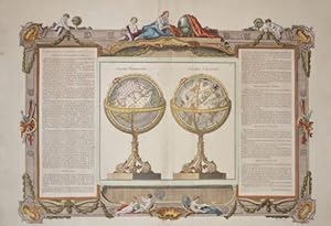
Globe Terrestre. Globe Cťleste.
Editť par Artist: Brion de la Tour Louis ( - 1803 ) Bordeaux; issued in: Paris; - Louis Brion de la Tour was a french cartographer and demographer With his knowledgebacame the famous ę Ingťnieur Gťographe du Roi ĽHe issued together with Louis Charles Desnos (1750-1790) several atlases and globes; ca: 1780, 1743
Vendeur : Antique Sommer& Sapunaru KG, MŁnchen, Allemagne
Membre d'association : ILAB VDA
…valuation du vendeur 5 sur 5 ťtoiles
Carte
EUR 780
Autre deviseEUR 45 expťdition depuis Allemagne vers Etats-UnisQuantitť disponible : 1 disponible(s)
Ajouter au panierTechnic: Copper print, colorit: original coloredcondition: Perfect condition, size (in cm): 37,5 x 52,5 cm cm; - Illustration of a world globe and a celestial globe with explanations on the left and right. The whole thing is surrounded by decorative ornaments and measurements.
-
![Image du vendeur pour [A set of two globes and one armillary sphere] Globe terrestre sur le quel Les Principaux Points sont placez sur les dernieres Observations de Mrs de l'Academie Royale des Sciences Par M. Buy de Mornas Geographe du Roi et des Enfants de France, [and] Globe celeste, [and armillary]. mis en vente par Daniel Crouch Rare Books Ltd](https://pictures.abebooks.com/inventory/md/md30752771954.jpg)
[A set of two globes and one armillary sphere] Globe terrestre sur le quel Les Principaux Points sont placez sur les dernieres Observations de Mrs de l'Academie Royale des Sciences Par M. Buy de Mornas Geographe du Roi et des Enfants de France, [and] Globe celeste, [and armillary].
Editť par Chez le Sr. Fortin, Ingenieur, Mecanicien du Roy pour les Globes et Spheres, rue de la Harpe
Vendeur : Daniel Crouch Rare Books Ltd, London, Royaume-Uni
Membre d'association : ABA ILAB PBFA
…valuation du vendeur 4 sur 5 ťtoiles
Manuscrit / Papier ancien
EUR 47†229,80
Autre deviseEUR 22,93 expťdition depuis Royaume-Uni vers Etats-UnisQuantitť disponible : 1 disponible(s)
Ajouter au panier"Ingenieur-Mechanicien pour les Globes et Spheres" A pair of terrestrial and celestial globes, each with 12 hand-coloured engraved paper gores over papier m‚chť and plaster sphere, varnished, paste-board meridian ring, wooden horizon ring, raised by four quadrant supports, mounted on an ebonized turned wood table stand. Together with an armillary sphere, containing globe with 12 hand-coloured engraved gores, over a papier m‚chť and plaster sphere, varnished wood, raised on four quadrant supports, with ebonised turned wood table stand. Biography Jean Fortin (1750-1831) was a scientific instrument-maker born in Picardy, France. Chiefly remembered for designing a barometer that ensured more accurate readings, he also produced celestial atlases, scales and was commissioned by the French royal family to make globes. He made terrestrial and celestial globes of 320 and 220mm (12 and 8.75 inches) diameter, as well as a terrestrial globe of 55mm (2.25 inches) to go into his armillary spheres. Fortin operated in Paris, with a shop in the Rue de la Harpe, where he referred to himself as "Ingenieur-Mecanicien pour les Globes et Spheres". He is also known for publishing the new celestial atlas of John Flamsteed (1646-1719) in 1762, which was highly influential as a source for celestial cartography throughout the rest of the century. His business was continued by his son Augustin, grandson Michel and great-grandson Augustin. Geography The prime meridian, which runs through the Canary Islands at Ferro, the equator, and the ecliptic are all graduated and labelled. The ecliptic includes the signs of the zodiac. Australia and New Zealand are drawn according to the discoveries of Abel Tasman; a dotted line marks a hypothetical northeast, east, and south coast of Australia. There are no tracks of voyages shown, but the lands seen by Quiros and David are marked. The two demi-meridian rings mark the latitude and longitude of the major cities of the world. North America extends almost to the north pole, and is apparently attached to Asia in the west and Greenland in the east. However, California is shown as a peninsula. Astronomy The equator is graduated and labelled "Cercle de L'Equateur" and "Cercle Equinoctial". The ecliptic is graduated; it is labelled "Ligne Eclipt" and "la Zodiaque" and provided with the symbols of the signs of the zodiac. There are labels for the "Artique" along the north polar circle "the Tropique de Capricorn", "the Tropique de Cander", "the Pol. d'eclipt. Australle", "the Colure des Aequinoxe" and "the Colure des Solstique". There is a magnitude table which is labelled "Gr. et Figure des Etoilles". The 48 Ptolemaic constellations are shown as well as the non-Ptolemaic constellations Antinous, La Chevelure de Berenice, La Croix, and La Colombe. The 12 southern constellations of Plancius are depicted. Armillary The Ptolemaic armillary sphere shows the cosmos with the earth at its centre. The complex device is made of moving circles: a meridian surmounted by an hour circle with metal pointer and an internal ring structure of polar circles, tropics and equator, joined by an equinoctial and a solstitial colure and surrounded by a planar zodiac band. These elements surround a rotating terrestrial globe, and a revolving sun and moon of flat paste-board discs, horizon band with calendar and zodiac. The four quadrant supporting the horizon ring give the latitude and longitude of major cities throughout the world.
-
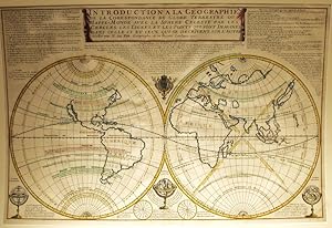
Introduction a la Geographie de la correspondance du globe Terrestre ou Mappe Monde avec la Sphere Celeste par les cercles, les lignes et les points qui sont imagines dans celle cy et ceux que se decrivent sur l'autre.
Editť par Paris, 1722
Art / Affiche / Gravure
EUR 2†990
Autre deviseEUR 50 expťdition depuis Espagne vers Etats-UnisQuantitť disponible : 1 disponible(s)
Ajouter au panierEtat : ACEPTABLE. - Atlas Curieux (1725) Ediciůn de Guillaume Danet. - Dressťe par N. De Fer. Geographe de sa Majestť Catolique, 1722 - A Paris chez Danet, Gendre de LAuteur sur le pont N. Dame, a la Sphere Royale, avec privilege du Roy. NicolŠs de Fer (1646-1720), cartůgrafo, geůgrafo, editor y grabador francťs se hizo cargo de la empresa iniciada por su padre Antoine De Fer. Fue Geografo del Rey de Francia. Formato (cm): 70x46.
-
![Image du vendeur pour Mappemonde celeste, ou Exposition des principes astronomiques relatifs au Globe terrestre et a la connoissance generale du Ciel. Application a ces deux objets, de diverses notions elementaires de geometrie, d'optique, de perspective et de calcul 1801 [LeatherBound] mis en vente par True World of Books](https://pictures.abebooks.com/inventory/md/md31617616423.jpg)
Mappemonde celeste, ou Exposition des principes astronomiques relatifs au Globe terrestre et a la connoissance generale du Ciel. Application a ces deux objets, de diverses notions elementaires de geometrie, d'optique, de perspective et de calcul 1801 [LeatherBound]
Date d'ťdition : 2025
Vendeur : True World of Books, Delhi, Inde
…valuation du vendeur 5 sur 5 ťtoiles
EUR 28,05
Autre deviseGratuit expťdition depuis Inde vers Etats-UnisQuantitť disponible : 18 disponible(s)
Ajouter au panierLeatherBound. Etat : New. LeatherBound edition. Condition: New. Reprinted from 1801 edition. Leather Binding on Spine and Corners with Golden leaf printing on spine. Bound in genuine leather with Satin ribbon page markers and Spine with raised gilt bands. A perfect gift for your loved ones. Pages: 389 NO changes have been made to the original text. This is NOT a retyped or an ocr'd reprint. Illustrations, Index, if any, are included in black and white. Each page is checked manually before printing. As this print on demand book is reprinted from a very old book, there could be some missing or flawed pages, but we always try to make the book as complete as possible. Fold-outs, if any, are not part of the book. If the original book was published in multiple volumes then this reprint is of only one volume, not the whole set. Sewing binding for longer life, where the book block is actually sewn (smythe sewn/section sewn) with thread before binding which results in a more durable type of binding. Pages: 389.
-
![Image du vendeur pour La geographie universelle ou Nouvelle methode pour apprendre facilement cette science. Contenant le traite de la sphere, la description du globe terrestre & celeste, les parties du monde, divisees en leurs etats . 1693 [LeatherBound] mis en vente par True World of Books](https://pictures.abebooks.com/inventory/md/md31616614722.jpg)
La geographie universelle ou Nouvelle methode pour apprendre facilement cette science. Contenant le traite de la sphere, la description du globe terrestre & celeste, les parties du monde, divisees en leurs etats . 1693 [LeatherBound]
Date d'ťdition : 2025
Vendeur : True World of Books, Delhi, Inde
…valuation du vendeur 5 sur 5 ťtoiles
EUR 28,05
Autre deviseGratuit expťdition depuis Inde vers Etats-UnisQuantitť disponible : 18 disponible(s)
Ajouter au panierLeatherBound. Etat : New. LeatherBound edition. Condition: New. Reprinted from 1693 edition. Leather Binding on Spine and Corners with Golden leaf printing on spine. Bound in genuine leather with Satin ribbon page markers and Spine with raised gilt bands. A perfect gift for your loved ones. Pages: 405 NO changes have been made to the original text. This is NOT a retyped or an ocr'd reprint. Illustrations, Index, if any, are included in black and white. Each page is checked manually before printing. As this print on demand book is reprinted from a very old book, there could be some missing or flawed pages, but we always try to make the book as complete as possible. Fold-outs, if any, are not part of the book. If the original book was published in multiple volumes then this reprint is of only one volume, not the whole set. Sewing binding for longer life, where the book block is actually sewn (smythe sewn/section sewn) with thread before binding which results in a more durable type of binding. Pages: 405.
-

Globe Terrestre / Globe Celeste
Vendeur : Tmecca Inc., Seoul, Corťe du Sud
Membre d'association : ILAB
…valuation du vendeur 5 sur 5 ťtoiles
Carte
EUR 52,61
Autre deviseEUR 17,02 expťdition depuis Corťe du Sud vers Etats-UnisQuantitť disponible : 1 disponible(s)
Ajouter au panierNo Binding. Etat : As New.
-
![Image du vendeur pour Mappemonde celeste, ou Exposition des principes astronomiques relatifs au Globe terrestre et a la connoissance generale du Ciel. Application a ces deux objets, de diverses notions elementaires de geometrie, d'optique, de perspective et de calcul - 1801 [Franz. Rev. An X] [Leather Bound] mis en vente par True World of Books](https://pictures.abebooks.com/inventory/md/md31885970490.jpg)
Mappemonde celeste, ou Exposition des principes astronomiques relatifs au Globe terrestre et a la connoissance generale du Ciel. Application a ces deux objets, de diverses notions elementaires de geometrie, d'optique, de perspective et de calcul - 1801 [Franz. Rev. An X] [Leather Bound]
Date d'ťdition : 2025
Vendeur : True World of Books, Delhi, Inde
…valuation du vendeur 5 sur 5 ťtoiles
EUR 33,31
Autre deviseGratuit expťdition depuis Inde vers Etats-UnisQuantitť disponible : 18 disponible(s)
Ajouter au panierLeatherBound. Etat : NEW. LeatherBound edition. Condition: New. Reprinted from 1801 [Franz. Rev. An X] edition. Leather Binding on Spine and Corners with Golden leaf printing on spine. Bound in genuine leather with Satin ribbon page markers and Spine with raised gilt bands. A perfect gift for your loved ones. NO changes have been made to the original text. This is NOT a retyped or an ocr'd reprint. Illustrations, Index, if any, are included in black and white. Each page is checked manually before printing. As this print on demand book is reprinted from a very old book, there could be some missing or flawed pages, but we always try to make the book as complete as possible. Fold-outs, if any, are not part of the book. If the original book was published in multiple volumes then this reprint is of only one volume, not the whole set. Sewing binding for longer life, where the book block is actually sewn (smythe sewn/section sewn) with thread before binding which results in a more durable type of binding. Pages: 390.
-
Mappemonde Cťleste, ou Exposition des principes astronomiques relatifs au Globe terrestre et ŗ la connoissance gťnťrale du Ciel. Application ŗ ces deux objets, de diverses notions ťlťmentaires de gťomťtrie, d'optique, de perspective et de calcul.
Vendeur : Librairie DiogŤne SARL, Lyon, France
…valuation du vendeur 5 sur 5 ťtoiles
EUR 150
Autre deviseEUR 18 expťdition depuis France vers Etats-UnisQuantitť disponible : 1 disponible(s)
Ajouter au panierA Paris, chez la veuve Durand, Libraire, De l'Imprimerie de Lesguillez, FrŤres, An X-1801, 1 volume in-8 de 202x122 mm environ, 1f. blanc, viij-370 pages, 1f. (notes, fautes ŗ corriger), 2 planches, 1 f. blanc, pleine basane fauve granitťe, titres dorťs sur dos lisse, tranches finement mouchetťes. Rares rousseurs et pages lťgŤrement brunies, sinon bon ťtat. Jean-Charles Maclot (1728-1805?) . Gťographe, professeur de cosmographie, censeur royal - Membre associť ŗ l'Acadťmie de Rouen.
-

Sphere de Copernic, Sphere de Ptolemťe, Globe Terrestre, Globe Celeste. -
Editť par Paris: [um ]., 1780
Vendeur : Antiquariat Tautenhahn, LŁbeck, Allemagne
Membre d'association : GIAQ ILAB VDA
…valuation du vendeur 5 sur 5 ťtoiles
Art / Affiche / Gravure
EUR 380
Autre deviseEUR 105 expťdition depuis Allemagne vers Etats-UnisQuantitť disponible : 1 disponible(s)
Ajouter au panierKupferstich 29,5 x 46,5 cm, BlattgrŲŖe 38,5 x 50,0 cm. Dargestellt sind nebeneinander 4 astronomische Modelle: zwei Armillarsphšren, ein Erdglobus und ein Himmelsglobus. Die Darstellung eingefasst mit einer Doppellinie. Im Blatt oben rechts der Buchstabe a. - Aus: Atlas Moderne oder Collection De Cartes Sur Toutes Les Parties du Globe Terrestre Par Plusieurs Auteurs, erschienen in Paris um 1780. - Papier gebršunt und leicht fleckig, der Druck kršftig. Leichte Abklatsche.
![Image du vendeur pour Mappemonde cťleste, ou Exposition des principes astronomiques relatifs au Globe terrestre et ŗ la connoissance gťnťrale du Ciel. Application ŗ ces deux objets, de diverses notions ťlťmentaires de gťometrie, d'optique, de perspective et de calcul 1801 [Leather Bound] mis en vente par Gyan Books Pvt. Ltd.](https://pictures.abebooks.com/inventory/md/md31990793965.jpg)
![Image du vendeur pour CORRESPONDANCE DU GLOBE TERRESTRE A LA SPHERE CELESTE. SITUATION DES HABITANS DU MONDE, DES CERCLES DE LONGITUDE ET DE LATITUDE, ET DES DIVERSES POSITIONS DE LA SPHERE [ATLAS] mis en vente par R. Hart Books](https://pictures.abebooks.com/inventory/md/md22595838169.jpg)


