Montant total (1 article articles) :
Destination de la commande :

great northern railway de weller edward (14 résultats)
Commentaires
Auteur :
weller edward
,
Titre :
great northern railway
Affiner les résultats avec une recherche avancée
Passer aux résultats principaux de la recherche
Filtres de recherche
Type d'article
- Tous les types de produits
- Livres (1)
- Magazines & Périodiques (Aucun autre résultat ne correspond ŕ ces critčres)
- Bandes dessinées (Aucun autre résultat ne correspond ŕ ces critčres)
- Partitions de musique (Aucun autre résultat ne correspond ŕ ces critčres)
- Art, Affiches et Gravures (Aucun autre résultat ne correspond ŕ ces critčres)
- Photographies (Aucun autre résultat ne correspond ŕ ces critčres)
- Cartes (13)
- Manuscrits & Papiers anciens (Aucun autre résultat ne correspond ŕ ces critčres)
Etat En savoir plus
- Neuf (Aucun autre résultat ne correspond ŕ ces critčres)
- Comme neuf, Trčs bon ou Bon (Aucun autre résultat ne correspond ŕ ces critčres)
- Assez bon ou satisfaisant (12)
- Moyen ou mauvais (Aucun autre résultat ne correspond ŕ ces critčres)
- Conformément ŕ la description (2)
Reliure
- Toutes
- Couverture rigide (Aucun autre résultat ne correspond ŕ ces critčres)
- Couverture souple (Aucun autre résultat ne correspond ŕ ces critčres)
Particularités
- Ed. originale (Aucun autre résultat ne correspond ŕ ces critčres)
- Signé (Aucun autre résultat ne correspond ŕ ces critčres)
- Jaquette (Aucun autre résultat ne correspond ŕ ces critčres)
- Avec images (13)
- Sans impressions ŕ la demande (14)
Langue (2)
Livraison gratuite
- Livraison gratuite ŕ destination de Etats-Unis (Aucun autre résultat ne correspond ŕ ces critčres)
Pays
Evaluation du vendeur
-
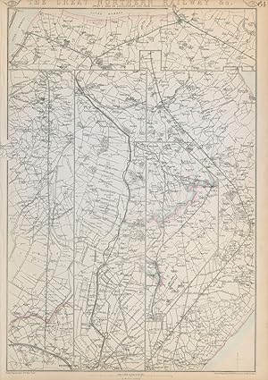
The Great Northern Railway Sheet 3. (Loop or Lincolnshire line from Peterborough)
Date d'édition : 1864
Vendeur : Antiqua Print Gallery, London, Royaume-Uni
Évaluation du vendeur 3 sur 5 étoiles

Carte
EUR 18,93
Autre deviseEUR 11,49 expédition depuis Royaume-Uni vers Etats-UnisQuantité disponible : 1 disponible(s)
Ajouter au panierEtat : Good. GREAT NORTHERN RAILWAY 3. Loop/Lincolnshire line. Peterborough. WELLER 1864 map. Antique map with original outline colour; Drawn & Engraved by Edwd. Weller (1864). 47.5 x 33.0cm, 18.75 x 13 inches. Condition: Good. The image shown may have been taken from a different example of this map than that which is offered for sale. The map you will receive is in good condition but there may be minor variations in the condition from that shown in the image. This map was coloured by hand at the time of publication, thus the colouration may vary slightly between different examples of the map; the colouring applied to the map you receive may differ slightly from that shown in the image. There is nothing printed on the reverse side, which is plain. The route (including all branches shown) runs through the towns of Barton upon Humber, Great Grimsby, Louth, Boston, Lincoln, Gainsborough, East Retford, Tattershall, Peterborough & Spalding.
-
The Great Northern Railway Sheet 1. (London to Grantham & Nottingham)
Date d'édition : 1864
Vendeur : Antiqua Print Gallery, London, Royaume-Uni
Évaluation du vendeur 3 sur 5 étoiles
Carte
EUR 18,93
Autre deviseEUR 11,49 expédition depuis Royaume-Uni vers Etats-UnisQuantité disponible : 1 disponible(s)
Ajouter au panierEtat : Good. GREAT NORTHERN RAILWAY 1. London to Grantham & Nottingham. WELLER 1864 old map. Antique map with original outline colour; Drawn & Engraved by Edwd. Weller (1864). 47.0 x 32.5cm, 18.5 x 12.75 inches. Condition: Good. The image shown may have been taken from a different example of this map than that which is offered for sale. The map you will receive is in good condition but there may be minor variations in the condition from that shown in the image. This map was coloured by hand at the time of publication, thus the colouration may vary slightly between different examples of the map; the colouring applied to the map you receive may differ slightly from that shown in the image. There is nothing printed on the reverse side, which is plain. The route (including all branches shown) runs through the towns of London, Hatfield, Hertford, Stevenage, Hitchin, Baldock, Shefford, Biggleswade, Botton, St Neots, Huntingdon, Peterborough, Stamford, Grantham, Luton, Dunstable, Bingham & Nottingham.
-
Great Northern Railway (Sheet 1. London to Grantham & Nottingham)
Date d'édition : 1863
Vendeur : Antiqua Print Gallery, London, Royaume-Uni
Évaluation du vendeur 3 sur 5 étoiles
Carte
EUR 18,93
Autre deviseEUR 11,49 expédition depuis Royaume-Uni vers Etats-UnisQuantité disponible : 3 disponible(s)
Ajouter au panierEtat : Good. GREAT NORTHERN RAILWAY 1. London to Grantham & Nottingham. WELLER 1863 old map. Antique map with original outline colour; Drawn & Engraved by Edwd. Weller (1863). 47.0 x 32.5cm, 18.5 x 12.75 inches. Condition: Good. The image shown may have been taken from a different example of this map than that which is offered for sale. The map you will receive is in good condition but there may be minor variations in the condition from that shown in the image. This map was coloured by hand at the time of publication, thus the colouration may vary slightly between different examples of the map; the colouring applied to the map you receive may differ slightly from that shown in the image. There is nothing printed on the reverse side, which is plain. The route (including all branches shown) runs through the towns of London, Hatfield, Hertford, Stevenage, Hitchin, Baldock, Shefford, Biggleswade, Botton, St Neots, Huntingdon, Peterborough, Stamford, Grantham, Luton, Dunstable, Bingham & Nottingham.
-
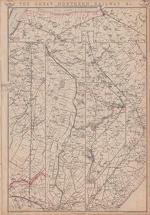
The Great Northern Railway &c. (Sheet 3. Loop or Lincolnshire line from Peterborough)
Date d'édition : 1863
Vendeur : Antiqua Print Gallery, London, Royaume-Uni
Évaluation du vendeur 3 sur 5 étoiles
Carte
EUR 18,93
Autre deviseEUR 11,49 expédition depuis Royaume-Uni vers Etats-UnisQuantité disponible : 2 disponible(s)
Ajouter au panierEtat : Good. GREAT NORTHERN RAILWAY 3. Loop/Lincolnshire line. Peterborough. WELLER 1863 map. Antique map with original outline colour; Drawn & Engraved by Edwd. Weller (1863). 47.5 x 33.0cm, 18.75 x 13 inches. Condition: Good. Tight top margin; The image shown may have been taken from a different example of this map than that which is offered for sale. The map you will receive is in good condition but there may be minor variations in the condition from that shown in the image. This map was coloured by hand at the time of publication, thus the colouration may vary slightly between different examples of the map; the colouring applied to the map you receive may differ slightly from that shown in the image. There is nothing printed on the reverse side, which is plain. The route (including all branches shown) runs through the towns of Barton upon Humber, Great Grimsby, Louth, Boston, Lincoln, Gainsborough, East Retford, Tattershall, Peterborough & Spalding.
-
The Great Northern Railway &c. (Sheet 3. Loop or Lincolnshire line from Peterborough)
Date d'édition : 1862
Vendeur : Antiqua Print Gallery, London, Royaume-Uni
Évaluation du vendeur 3 sur 5 étoiles
Carte
EUR 18,93
Autre deviseEUR 11,49 expédition depuis Royaume-Uni vers Etats-UnisQuantité disponible : 1 disponible(s)
Ajouter au panierEtat : Good. GREAT NORTHERN RAILWAY 3. Loop/Lincolnshire line. Peterborough. WELLER 1862 map. Antique map with original outline colour; Drawn & Engraved by Edwd. Weller (1862). 47.5 x 33.0cm, 18.75 x 13 inches. Condition: Good. There is nothing printed on the reverse side, which is plain. The route (including all branches shown) runs through the towns of Barton upon Humber, Great Grimsby, Louth, Boston, Lincoln, Gainsborough, East Retford, Tattershall, Peterborough & Spalding.
-

GREAT NORTHERN RAILWAY, Sheet 1, London to Grantham & Nottingham - an Original Antique Map, 1860
Edité par Weekly Dispatch, London, 1860
Langue: anglais
Vendeur : K Books Ltd ABA ILAB, York, YORKS, Royaume-Uni
Membre d'association : ABA ILAB PBFA
Évaluation du vendeur 5 sur 5 étoiles

EUR 47,33
Autre deviseEUR 22,40 expédition depuis Royaume-Uni vers Etats-UnisQuantité disponible : 1 disponible(s)
Ajouter au panierNo Binding. Etat : Very Good. Edward WELLER (illustrateur). An original antique map, mounted (matted) and ready to frame. No date of publication but c1860. The route of the Great Northern Railway is shown in 4 strips arranged side-by-side with counties coloured in outline. Other railway routes are shown as they join the Great Northern. Some fraying to corners, otherwise good.
-
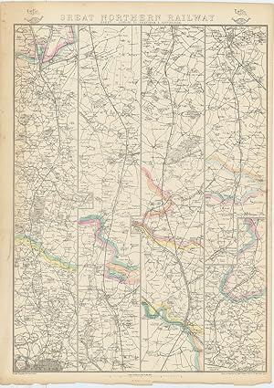
The Great Northern Railway Sheet 2. (Continuation to York Leeds &c.)
Date d'édition : 1864
Vendeur : Antiqua Print Gallery, London, Royaume-Uni
Évaluation du vendeur 3 sur 5 étoiles
Carte
EUR 24,85
Autre deviseEUR 11,49 expédition depuis Royaume-Uni vers Etats-UnisQuantité disponible : 1 disponible(s)
Ajouter au panierEtat : Good. GREAT NORTHERN RAILWAY 2. Grantham to York, Leeds & Sheffield. WELLER 1864 map. Antique map with original outline colour; Drawn & Engraved by Edwd. Weller (1864). 47.5 x 33.5cm, 18.75 x 13 inches. Condition: Good. The image shown may have been taken from a different example of this map than that which is offered for sale. The map you will receive is in good condition but there may be minor variations in the condition from that shown in the image. This map was coloured by hand at the time of publication, thus the colouration may vary slightly between different examples of the map; the colouring applied to the map you receive may differ slightly from that shown in the image. There is nothing printed on the reverse side, which is plain. The route (including all branches shown) runs through the towns of East Retford, Worksop, Sheffield, York, Bawtry, Doncaster, Pontefract, Wakefield, Sherburn, Leeds, Tuxford, Newark upon Trent & Grantham.
-
The Great Northern Railway &c. (Sheet 2. Continuation to York Leeds &c.)
Date d'édition : 1863
Vendeur : Antiqua Print Gallery, London, Royaume-Uni
Évaluation du vendeur 3 sur 5 étoiles
Carte
EUR 24,85
Autre deviseEUR 11,49 expédition depuis Royaume-Uni vers Etats-UnisQuantité disponible : 2 disponible(s)
Ajouter au panierEtat : Good. GREAT NORTHERN RAILWAY 2. Grantham to York, Leeds & Sheffield. WELLER 1863 map. Antique map with original outline colour; Drawn & Engraved by Edwd. Weller (1863). 47.5 x 33.5cm, 18.75 x 13 inches. Condition: Good. Tight top margin; The image shown may have been taken from a different example of this map than that which is offered for sale. The map you will receive is in good condition but there may be minor variations in the condition from that shown in the image. This map was coloured by hand at the time of publication, thus the colouration may vary slightly between different examples of the map; the colouring applied to the map you receive may differ slightly from that shown in the image. There is nothing printed on the reverse side, which is plain. The route (including all branches shown) runs through the towns of East Retford, Worksop, Sheffield, York, Bawtry, Doncaster, Pontefract, Wakefield, Sherburn, Leeds, Tuxford, Newark upon Trent & Grantham.
-

Outline Map Showing The Route of The Great Northern Railway from Grantham to York via Leeds and Sheffield (from the Dispatch Atlas)
Edité par Weekly Dispatch, 1863
Vendeur : Morning Mist Books and Maps, Cirencester, Royaume-Uni
Évaluation du vendeur 5 sur 5 étoiles
Carte
EUR 11,83
Autre deviseEUR 45,95 expédition depuis Royaume-Uni vers Etats-UnisQuantité disponible : 1 disponible(s)
Ajouter au panierNo Binding. Etat : Very Good. Sheet 2 showing the Great Northern Railway route from Grantham as far as York but also showing the routes to Sheffield and Leeds. Four sections (left to right): East Retford to Sheffield; Church Fenton to York; Sutton cum Lound to Leeds; Grantham to East Retford. Outline colouring for county borders. Drawn, engraved and lithographed by Edward Weller. Clear printing. A little toned. Edges scuffed, creased and with small nicks. Map slightly offset. Thin paper. Scale of half inch to one mile. Sheet size when open: 33.9 cm by 48.9cm approx. (non368flat).
-

Outline Map Showing The Route of The Great Northern Railway from Grantham to York via Leeds and Sheffield (from Cassell's British Atlas)
Edité par Cassell, Petter & Galpin, 1865
Vendeur : Morning Mist Books and Maps, Cirencester, Royaume-Uni
Évaluation du vendeur 5 sur 5 étoiles
Carte
EUR 14,20
Autre deviseEUR 45,95 expédition depuis Royaume-Uni vers Etats-UnisQuantité disponible : 1 disponible(s)
Ajouter au panierNo Binding. Etat : Good. Almost identical to the weekly dispatch atlas maps: same quality paper and near identical maps: just a few alterations/additions. Title, part trimmed to upper edge. Faint colouring for county borders. Offset printing. Edges scuffed. Sheet 2 shows the Great Northern Railway route from Grantham as far as York but also showing the routes to Sheffield and Leeds. Four sections (left to right): East Retford to Sheffield; Church Fenton to York; Sutton cum Lound to Leeds; Grantham to East Retford. Sheet size: 33.2cm by 49.5cm approx. More details available on request. (non369flat).
-
Outline Map Showing The Route of The Great Northern Railway from London to Nottingham (from the Dispatch Atlas)
Edité par Weekly Dispatch, 1863
Vendeur : Morning Mist Books and Maps, Cirencester, Royaume-Uni
Évaluation du vendeur 5 sur 5 étoiles
Carte
EUR 14,20
Autre deviseEUR 45,95 expédition depuis Royaume-Uni vers Etats-UnisQuantité disponible : 1 disponible(s)
Ajouter au panierNo Binding. Etat : Very Good. Sheet 1 showing the Great Northern Railway route from London as far as Nottingham with a smaller section of the map showing the side route to Dunstable. Four columns: London to Henlow End; Henlow End to Yaxley; Yaxley to Grantham; Welwyn to Dunstable and Grantham to Nottingham (the fourth column is divided into two different sections). Outline colouring for county borders. Drawn, engraved and lithographed by Edward Weller. Clear printing. A few marginal tears. Slight creasing from handling. Central fold. One archival repair to the reverse. Light toning. Thin paper. Scale of half inch to one mile. Sheet size when open: 35cm by 49.5cm approx. (non351flat).
-
Outline Map Showing The Route of The Great Northern Railway from Grantham to York via Leeds and Sheffield (from the Dispatch Atlas)
Edité par Weekly Dispatch, 1863
Vendeur : Morning Mist Books and Maps, Cirencester, Royaume-Uni
Évaluation du vendeur 5 sur 5 étoiles
Carte
EUR 17,75
Autre deviseEUR 45,95 expédition depuis Royaume-Uni vers Etats-UnisQuantité disponible : 1 disponible(s)
Ajouter au panierNo Binding. Etat : Very Good. Sheet 2 showing the Great Northern Railway route from Grantham as far as York but also showing the routes to Sheffield and Leeds. Four sections (left to right): East Retford to Sheffield; Church Fenton to York; Sutton cum Lound to Leeds; Grantham to East Retford. Outline colouring for county borders. Drawn, engraved and lithographed by Edward Weller. Clear printing. A few marginal scuffs. A little toning. Slight creasing from handling. Thin paper. Scale of half inch to one mile. Sheet size when open: 33.7 cm by 48.3cm approx. (non352flat).
-
The Great Northern Railway & Co. (Sheet 1, London to Grantham & Nottingham)
Edité par LondonPublished at the "Weekly Dispatch" Office ., 1863
Vendeur : Robert Frew Ltd. ABA ILAB, London, Royaume-Uni
Membre d'association : ABA ILAB PBFA
Évaluation du vendeur 4 sur 5 étoiles

Carte
EUR 59,16
Autre deviseEUR 11,49 expédition depuis Royaume-Uni vers Etats-UnisQuantité disponible : 1 disponible(s)
Ajouter au panierOriginal lithographed map. Map dimensions 43 x 32 , overall sheet size 47 x 34 cm. Original outline colour. Overall very good condition.
-

The Great Northern Railway & Co. (Sheet 2 Continuation to York, Leeds & Co.)
Edité par LondonPublished at the "Weekly Dispatch" Office ., 1863
Vendeur : Robert Frew Ltd. ABA ILAB, London, Royaume-Uni
Membre d'association : ABA ILAB PBFA
Évaluation du vendeur 4 sur 5 étoiles
Carte
EUR 59,16
Autre deviseEUR 11,49 expédition depuis Royaume-Uni vers Etats-UnisQuantité disponible : 1 disponible(s)
Ajouter au panierOriginal lithographed map. Map dimensions 45.5 x 32 , overall sheet size 48 x 34 cm. Original outline colour. Overall very good condition.