
Montant total (1 article articles) :
Destination de la commande :

hadrians wall path map (80 résultats)
Passer aux résultats principaux de la recherche
Filtres de recherche
Type d'article
- Tous les types de produits
- Livres (75)
- Magazines & Périodiques (Aucun autre résultat ne correspond ŕ ces critčres)
- Bandes dessinées (Aucun autre résultat ne correspond ŕ ces critčres)
- Partitions de musique (Aucun autre résultat ne correspond ŕ ces critčres)
- Art, Affiches et Gravures (Aucun autre résultat ne correspond ŕ ces critčres)
- Photographies (Aucun autre résultat ne correspond ŕ ces critčres)
- Cartes (5)
- Manuscrits & Papiers anciens (Aucun autre résultat ne correspond ŕ ces critčres)
Etat En savoir plus
- Neuf (69)
- Comme neuf, Trčs bon ou Bon (6)
- Assez bon ou satisfaisant (5)
- Moyen ou mauvais (Aucun autre résultat ne correspond ŕ ces critčres)
- Conformément ŕ la description (Aucun autre résultat ne correspond ŕ ces critčres)
Reliure
- Toutes
- Couverture rigide (Aucun autre résultat ne correspond ŕ ces critčres)
- Couverture souple (45)
Particularités
- Ed. originale (Aucun autre résultat ne correspond ŕ ces critčres)
- Signé (Aucun autre résultat ne correspond ŕ ces critčres)
- Jaquette (Aucun autre résultat ne correspond ŕ ces critčres)
- Avec images (23)
- Sans impressions ŕ la demande (80)
Langue (1)
Livraison gratuite
Pays
Evaluation du vendeur
-

Hadrians Wall Path Map Booklet
Vendeur : Aspen Book Co., Denver, CO, Etats-Unis
Évaluation du vendeur 5 sur 5 étoiles

EUR 5,33
Livraison gratuite
Expédition nationale : Etats-UnisQuantité disponible : 1 disponible(s)
Ajouter au panierEtat : good. A well-loved companion. Corners and cover might show a little wear, and you could find some notes or highlights. The dust jacket might be MIA, it might have been a library book and extras aren't guaranteedâ"but the story's all there!
-

Hadrian's Wall Path map booklet
Vendeur : PBShop.store US, Wood Dale, IL, Etats-Unis
Évaluation du vendeur 5 sur 5 étoiles
EUR 13,58
Livraison gratuite
Expédition nationale : Etats-UnisQuantité disponible : 15 disponible(s)
Ajouter au panierPAP. Etat : New. New Book. Shipped from UK. Established seller since 2000.
-

Hadrian's Wall Path map booklet
Vendeur : Rarewaves.com USA, London, LONDO, Royaume-Uni
Évaluation du vendeur 5 sur 5 étoiles
EUR 14,16
Livraison gratuite
Expédition depuis Royaume-Uni vers Etats-UnisQuantité disponible : 15 disponible(s)
Ajouter au panierPaperback. Etat : New. Hadrian's Wall Path is a superb National Trail that runs for 85 miles (137 km) beside the Roman wall between Bowness-on-Solway and Wallsend, near Newcastle. Experts can't agree whether it's better to walk it from west to east or vice versa, so this booklet uniquely does both: just flip it to reverse the direction with miles correctly numbered from 0 to 85. This map booklet helps you to enjoy this classic walk in either direction or in both: route rewalked and updated in late 2025route line more accurate than OS mapping and the official websitetwo booklets in one, west-to-east and east-to-westcustom, clear mapping at 1:50,000: no irrelevant clutterforts, milecastles and visitor centres shownincludes city centre plans for Carlisle and Newcastle upon Tynelightweight (50 grams) and small enough to slip in your pocketrobust, opens flat and printed on rainproof paper.
-

Hadrian's Wall Path map booklet
Vendeur : Rarewaves USA, OSWEGO, IL, Etats-Unis
Évaluation du vendeur 5 sur 5 étoiles
EUR 14,24
Livraison gratuite
Expédition nationale : Etats-UnisQuantité disponible : 15 disponible(s)
Ajouter au panierPaperback. Etat : New. Hadrian's Wall Path is a superb National Trail that runs for 85 miles (137 km) beside the Roman wall between Bowness-on-Solway and Wallsend, near Newcastle. Experts can't agree whether it's better to walk it from west to east or vice versa, so this booklet uniquely does both: just flip it to reverse the direction with miles correctly numbered from 0 to 85. This map booklet helps you to enjoy this classic walk in either direction or in both: route rewalked and updated in late 2025route line more accurate than OS mapping and the official websitetwo booklets in one, west-to-east and east-to-westcustom, clear mapping at 1:50,000: no irrelevant clutterforts, milecastles and visitor centres shownincludes city centre plans for Carlisle and Newcastle upon Tynelightweight (50 grams) and small enough to slip in your pocketrobust, opens flat and printed on rainproof paper.
-
Hadrian's Wall Path Map Booklet 2 Revised edition
Vendeur : GreatBookPrices, Columbia, MD, Etats-Unis
Évaluation du vendeur 5 sur 5 étoiles
EUR 13,25
Expédition ŕ EUR 2,31
Expédition nationale : Etats-UnisQuantité disponible : 3 disponible(s)
Ajouter au panierEtat : New.
-

Hadrian's Wall Path Map Booklet
Vendeur : Rarewaves USA, OSWEGO, IL, Etats-Unis
Évaluation du vendeur 5 sur 5 étoiles
EUR 15,64
Livraison gratuite
Expédition nationale : Etats-UnisQuantité disponible : Plus de 20 disponibles
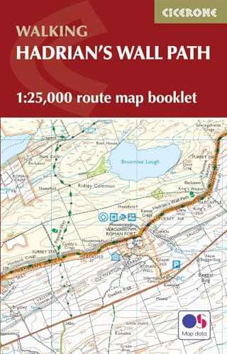
Ajouter au panierPaperback. Etat : New. Uncover the fascinating history and stunning landscapes of the iconic Hadrian's Wall Path National Trail. Stretching 84 miles (135 km) from Bowness-on-Solway on the Cumbrian coast to Wallsend in Newcastle, this legendary route traces the line of the UNESCO World Heritage Roman frontier. This map book provides all the route mapping you need to walk the entire Hadrian's Wall Path National Trail: Features 1:25,000 Ordnance Survey (OS) mapping for accuracy and clarityExplore historic Roman sites, including Birdoswald, Housesteads, Chesters Fort, Segedunum, Vindolanda, and Carlisle CastleCompact and portable size, perfect for your jacket pocket or rucksackSuitable for walking in either direction, from west to east or east to west2-stage route extension through Newcastle to South Shields on the east coast is also shown For step-by-step route descriptions, an accompanying Cicerone guidebook, 'Hadrian's Wall Path,' is also available Whether you're captivated by ancient Roman history, drawn to breathtaking scenery, or seeking a memorable long-distance adventure, this map will help you plan and enjoy every step of your journey along Hadrian's Wall Path.
-
Hadrians Wall Path map booklet (Paperback)
Langue: anglais
Edité par Rucksack Readers, Dunblane, 2025
ISBN 10 : 1913817350 ISBN 13 : 9781913817350
Vendeur : Grand Eagle Retail, Bensenville, IL, Etats-Unis
Évaluation du vendeur 5 sur 5 étoiles
EUR 15,80
Livraison gratuite
Expédition nationale : Etats-UnisQuantité disponible : 1 disponible(s)
Ajouter au panierPaperback. Etat : new. Paperback. Hadrians Wall Path is a superb National Trail that runs for 85 miles (137 km) beside the Roman wall between Bowness-on-Solway and Wallsend, near Newcastle. Experts can't agree whether it's better to walk it from west to east or vice versa, so this booklet uniquely does both: just flip it to reverse the direction with miles correctly numbered from 0 to 85. This map booklet helps you to enjoy this classic walk in either direction or in both: route rewalked and updated in late 2025route line more accurate than OS mapping and the official websitetwo booklets in one, west-to-east and east-to-westcustom, clear mapping at 1:50,000: no irrelevant clutterforts, milecastles and visitor centres shownincludes city centre plans for Carlisle and Newcastle upon Tynelightweight (50 grams) and small enough to slip in your pocketrobust, opens flat and printed on rainproof paper. Hadrians Wall Path is a superb National Trail that runs for 85 miles beside the Roman wall between Bowness-on-Solway and Wallsend, near Newcastle. Experts can't agree whether it's better to walk it from west to east or vice versa, so this booklet uniquely maps it in both directions, scale 1:50,000, with miles correctly numbered each way. Shipping may be from multiple locations in the US or from the UK, depending on stock availability.
-
Hadrian's Wall Path Map Booklet 2 Revised edition
Vendeur : GreatBookPrices, Columbia, MD, Etats-Unis
Évaluation du vendeur 5 sur 5 étoiles
EUR 13,67
Expédition ŕ EUR 2,31
Expédition nationale : Etats-UnisQuantité disponible : 3 disponible(s)
Ajouter au panierEtat : As New. Unread book in perfect condition.
-

Hadrian's Wall Path Map Booklet
Vendeur : Rarewaves.com USA, London, LONDO, Royaume-Uni
Évaluation du vendeur 5 sur 5 étoiles
EUR 16,31
Livraison gratuite
Expédition depuis Royaume-Uni vers Etats-UnisQuantité disponible : 5 disponible(s)
Ajouter au panierPaperback. Etat : New. Uncover the fascinating history and stunning landscapes of the iconic Hadrian's Wall Path National Trail. Stretching 84 miles (135 km) from Bowness-on-Solway on the Cumbrian coast to Wallsend in Newcastle, this legendary route traces the line of the UNESCO World Heritage Roman frontier. This map book provides all the route mapping you need to walk the entire Hadrian's Wall Path National Trail: Features 1:25,000 Ordnance Survey (OS) mapping for accuracy and clarityExplore historic Roman sites, including Birdoswald, Housesteads, Chesters Fort, Segedunum, Vindolanda, and Carlisle CastleCompact and portable size, perfect for your jacket pocket or rucksackSuitable for walking in either direction, from west to east or east to west2-stage route extension through Newcastle to South Shields on the east coast is also shown For step-by-step route descriptions, an accompanying Cicerone guidebook, 'Hadrian's Wall Path,' is also available Whether you're captivated by ancient Roman history, drawn to breathtaking scenery, or seeking a memorable long-distance adventure, this map will help you plan and enjoy every step of your journey along Hadrian's Wall Path.
-
Hadrian's Wall Path Map Booklet
Vendeur : PBShop.store US, Wood Dale, IL, Etats-Unis
Évaluation du vendeur 5 sur 5 étoiles
EUR 16,40
Livraison gratuite
Expédition nationale : Etats-UnisQuantité disponible : 15 disponible(s)
Ajouter au panierPAP. Etat : New. New Book. Shipped from UK. Established seller since 2000.
-
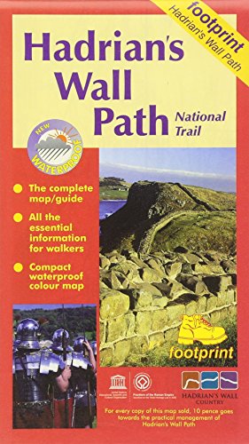
Hadrian's Wall Path: Bowness to Wallsend (Footprint Map & Guide)
Vendeur : WorldofBooks, Goring-By-Sea, WS, Royaume-Uni
Évaluation du vendeur 5 sur 5 étoiles
EUR 10,14
Expédition ŕ EUR 6,54
Expédition depuis Royaume-Uni vers Etats-UnisQuantité disponible : 1 disponible(s)
Ajouter au panierPaperback. Etat : Very Good. The book has been read, but is in excellent condition. Pages are intact and not marred by notes or highlighting. The spine remains undamaged.
-

Hadrian's Wall Path (National Trail Guidebook & OS 1:25K Map Booklet) (Cicerone Walking Guide): National Trail: Described west-east and east-west (Cicerone guides)
Vendeur : WeBuyBooks, Rossendale, LANCS, Royaume-Uni
Évaluation du vendeur 5 sur 5 étoiles
EUR 10,14
Expédition ŕ EUR 6,98
Expédition depuis Royaume-Uni vers Etats-UnisQuantité disponible : 1 disponible(s)
Ajouter au panierEtat : Very Good. Most items will be dispatched the same or the next working day. A copy that has been read, but is in excellent condition. Pages are intact and not marred by notes or highlighting. The spine remains undamaged.
-
Hadrian's Wall Path map booklet
Vendeur : PBShop.store UK, Fairford, GLOS, Royaume-Uni
Évaluation du vendeur 5 sur 5 étoiles
EUR 13,66
Expédition ŕ EUR 3,84
Expédition depuis Royaume-Uni vers Etats-UnisQuantité disponible : 15 disponible(s)
Ajouter au panierPAP. Etat : New. New Book. Shipped from UK. Established seller since 2000.
-

Hadrian's Wall Path Map Booklet (Paperback)
Vendeur : Grand Eagle Retail, Bensenville, IL, Etats-Unis
Évaluation du vendeur 5 sur 5 étoiles
EUR 17,40
Livraison gratuite
Expédition nationale : Etats-UnisQuantité disponible : 1 disponible(s)
Ajouter au panierPaperback. Etat : new. Paperback. Uncover the fascinating history and stunning landscapes of the iconic Hadrians Wall Path National Trail. Stretching 84 miles (135 km) from Bowness-on-Solway on the Cumbrian coast to Wallsend in Newcastle, this legendary route traces the line of the UNESCO World Heritage Roman frontier.This map book provides all the route mapping you need to walk the entire Hadrians Wall Path National Trail:Features 1:25,000 Ordnance Survey (OS) mapping for accuracy and clarityExplore historic Roman sites, including Birdoswald, Housesteads, Chesters Fort, Segedunum, Vindolanda, and Carlisle CastleCompact and portable size, perfect for your jacket pocket or rucksackSuitable for walking in either direction, from west to east or east to west2-stage route extension through Newcastle to South Shields on the east coast is also shown For step-by-step route descriptions, an accompanying Cicerone guidebook, Hadrians Wall Path, is also availableWhether youre captivated by ancient Roman history, drawn to breathtaking scenery, or seeking a memorable long-distance adventure, this map will help you plan and enjoy every step of your journey along Hadrians Wall Path. Map of the 84 mile (135km) Hadrian's Wall Path National Trail, from Bowness-on-Solway to Wallsend, Newcastle. The full route line is shown on 1:25,000 OS maps and can be used to walk the trail in either direction. Shipping may be from multiple locations in the US or from the UK, depending on stock availability.
-
Hadrian's Wall Path Map Booklet
Vendeur : PBShop.store UK, Fairford, GLOS, Royaume-Uni
Évaluation du vendeur 5 sur 5 étoiles
EUR 14,41
Expédition ŕ EUR 3,84
Expédition depuis Royaume-Uni vers Etats-UnisQuantité disponible : 15 disponible(s)
Ajouter au panierPAP. Etat : New. New Book. Shipped from UK. Established seller since 2000.
-
Hadrian's Wall Path Map Booklet
Langue: anglais
ISBN 10 : 1913817350 ISBN 13 : 9781913817350
Vendeur : GreatBookPrices, Columbia, MD, Etats-Unis
Évaluation du vendeur 5 sur 5 étoiles
EUR 11,19
Expédition ŕ EUR 2,31
Expédition nationale : Etats-UnisQuantité disponible : Plus de 20 disponibles
Ajouter au panierEtat : New.
-
Hadrian's Wall Path map booklet
Vendeur : Brook Bookstore On Demand, Napoli, NA, Italie
Évaluation du vendeur 5 sur 5 étoiles
EUR 15,24
Expédition ŕ EUR 4
Expédition depuis Italie vers Etats-UnisQuantité disponible : Plus de 20 disponibles
Ajouter au panierEtat : new.
-

Hadrian's Wall Path National Trail Map
Langue: anglais
Edité par HarperCollins Publishers, 2023
ISBN 10 : 0008602980 ISBN 13 : 9780008602987
Vendeur : PBShop.store US, Wood Dale, IL, Etats-Unis
Évaluation du vendeur 5 sur 5 étoiles
EUR 14,43
Livraison gratuite
Expédition nationale : Etats-UnisQuantité disponible : 1 disponible(s)
Ajouter au panierUNK. Etat : New. New Book. Shipped from UK. Established seller since 2000.
-
Hadrian's Wall Path National Trail Map
Langue: anglais
Edité par HarperCollins Publishers, 2023
ISBN 10 : 0008602980 ISBN 13 : 9780008602987
Vendeur : PBShop.store UK, Fairford, GLOS, Royaume-Uni
Évaluation du vendeur 5 sur 5 étoiles
EUR 10,95
Expédition ŕ EUR 3,84
Expédition depuis Royaume-Uni vers Etats-UnisQuantité disponible : 1 disponible(s)
Ajouter au panierUNK. Etat : New. New Book. Shipped from UK. Established seller since 2000.
-
Hadrian's Wall Path Map Booklet
Langue: anglais
ISBN 10 : 1913817350 ISBN 13 : 9781913817350
Vendeur : GreatBookPrices, Columbia, MD, Etats-Unis
Évaluation du vendeur 5 sur 5 étoiles
EUR 12,70
Expédition ŕ EUR 2,31
Expédition nationale : Etats-UnisQuantité disponible : Plus de 20 disponibles
Ajouter au panierEtat : As New. Unread book in perfect condition.
-
Hadrian's Wall Path Map Booklet: 1:25,000 OS Route Mapping
Vendeur : Majestic Books, Hounslow, Royaume-Uni
Évaluation du vendeur 4 sur 5 étoiles

EUR 15,11
Expédition ŕ EUR 7,59
Expédition depuis Royaume-Uni vers Etats-UnisQuantité disponible : 3 disponible(s)
Ajouter au panierEtat : New.
-
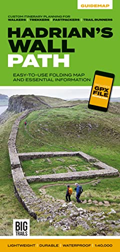
Hadrian's Wall Path : Easy-to-use Folding Map and Essential Information, With Custom Itinerary Planning for Walkers, Trekkers, Fastpackers and Trail Runners
Livre 3 sur 4 : Big Trails GuidemapsVendeur : GreatBookPrices, Columbia, MD, Etats-Unis
Évaluation du vendeur 5 sur 5 étoiles
EUR 15,18
Expédition ŕ EUR 2,31
Expédition nationale : Etats-UnisQuantité disponible : Plus de 20 disponibles
Ajouter au panierEtat : As New. Unread book in perfect condition.
-
Hadrian's Wall Path National Trail Planning Map
Vendeur : Majestic Books, Hounslow, Royaume-Uni
Évaluation du vendeur 4 sur 5 étoiles
EUR 9,98
Expédition ŕ EUR 7,59
Expédition depuis Royaume-Uni vers Etats-UnisQuantité disponible : 3 disponible(s)
Ajouter au panierEtat : New.
-

Hadrians Wall Path National Trail Map (Folded)
Langue: anglais
Edité par HarperCollins Publishers, London, 2023
ISBN 10 : 0008602980 ISBN 13 : 9780008602987
Vendeur : Grand Eagle Retail, Bensenville, IL, Etats-Unis
Évaluation du vendeur 5 sur 5 étoiles
EUR 17,83
Livraison gratuite
Expédition nationale : Etats-UnisQuantité disponible : 1 disponible(s)
Ajouter au panierFolded. Etat : new. Folded. Perfect guide and map for planning your adventure along Hadrians Wall. Highlights of this Planning Map include:More than 20 highlighted places of interest with detailed descriptions and attractive photographs, including: the Vindolanda archaeological site, Chesters Roman fort, and Steel Rigg viewpoint.A comprehensive index to more than 400 cities, towns and villagesA clear, visible route plotted across the mapAdvice on safety and security when travelling along the route, as well as the countryside code and the code of conductPart of the National Trail network, this long-distance footpath covers 84 miles (135 km) along the line of Hadrian's Wall from coast-to-coast. Starting in Wallsend in Newcastle and ending in Bowness-on-Solway, this path weaves through beautiful countryside, encountering historic remains of Roman forts and milecastles, and splendid bridges. A suggested walking itinerary makes it easy for users to plan their journey along this popular route. Perfect guide and map for planning your adventure along Hadrians Wall. Shipping may be from multiple locations in the US or from the UK, depending on stock availability.
-

Hadrian's Wall Path National Trail Official Map: with Ordnance Survey mapping (A -Z Adventure Series)
Livre 19 sur 21 : A -Z AdventureLangue: anglais
Edité par HarperCollins Publishers, United Kingdom, 2019
ISBN 10 : 1782571655 ISBN 13 : 9781782571650
Vendeur : WorldofBooks, Goring-By-Sea, WS, Royaume-Uni
Évaluation du vendeur 5 sur 5 étoiles
EUR 18,30
Expédition ŕ EUR 6,54
Expédition depuis Royaume-Uni vers Etats-UnisQuantité disponible : 2 disponible(s)
Ajouter au panierPaperback. Etat : Very Good. The A-Z Adventure Series of maps combines the best of OS and A-Z, creating the perfect companion for walkers, off-road cyclists, horse riders and anyone wishing to explore the great outdoors. Hadrian's Wall Path is a National Trail which follows the line of Hadrian's Wall from coast-to-coast. The 84 mile (135km) path weaves through beautiful countryside, encountering historic remains of Roman forts and milecastles, splendid bridges, views from the Whin Sill escarpment and Solway salt marshes. Starting in Wallsend in Newcastle and ending in Bowness-on-Solway, the route on the map is clearly highlighted in yellow with mileage markers added to gauge distances when planning sections of the walk to enjoy. This official National Trail Map* of Hadrian's Wall Path features 38 pages of continuous Ordnance Survey 1:25000 mapping, providing complete coverage of the Hadrian's Wall Path. The atlas includes a route planner showing distances between places and the amenities available, featuring: Information Centres Hotels/B&Bs Youth Hostels Campsites (seasonal opening) Public Houses Shops Restaurants Cafes (seasonal opening) Petrol Stations Also featured is advice on safety and security when walking and a selection of QR codes linked to useful websites, including temporary route updates from the National Trails, regional information, map reading advice and weather reports. Unlike the original OS sheets, this A-Z Adventure Atlas includes a comprehensive index to towns, villages, hamlets and locations, natural features, nature reserves, car parks and youth hostels, making it easy to find the required location quickly. Each index entry has a page reference and a six figure National Grid Reference. With a book size of 240mm x 134mm it is the same size as the standard folded OS map. Other National Trails available within the A-Z Adventure series include: Cotswold Way, North Downs Way, Offa's Dyke Path, Pembrokeshire Coast Path, Pennine Way, South Downs Way, SW Coast Path, Thames Path and The Ridgeway. *A-Z is the official mapping partner of the National Trails. The book has been read, but is in excellent condition. Pages are intact and not marred by notes or highlighting. The spine remains undamaged.
-

Hadrian's Wall Path (National Trail Guidebook & OS 1:25K Map Booklet) (Cicerone Walking Guide): National Trail: Described west-east and east-west (Cicerone guides)
Vendeur : Sell Books, Elland, YORKS, Royaume-Uni
Évaluation du vendeur 5 sur 5 étoiles
EUR 10,16
Expédition ŕ EUR 14,18
Expédition depuis Royaume-Uni vers Etats-UnisQuantité disponible : 1 disponible(s)
Ajouter au panierpaperback. Etat : Good. Our good condition books are generally good for reading but not for gifting or collecting. They could have imperfections such as creasing, fanning, inscriptions, margin notes, yellowing, staining on edge or cover or pages, bumps, scuffs, etc etc (sometimes multiple of these). It's a wide category that encompasses anything that isn't almost-new down to anything that is slightly better than poor. We would NOT recommend gifting Good books - these should be considered reading copies. Our books are dispatched from a Yorkshire former cotton mill. We list via barcode/ISBN so please note that the images are stock images and may not be the exact copy you receive, furthermore the details about edition and year might not be accurate as many publishers reuse the same ISBN for multiple editions and as we simply scan a barcode or enter an ISBN we do not check the validity of the edition data when listing. If you're looking for an exact edition please don't order (at least not without checking with us first, although we don't always have time to check). We aim to dispatch prompty, the service used will depend on order value and book size. We can ship to most countries, see our shipping policies. Payment is via Abe only.
-
Hadrian's Wall Path National Trail Map
Langue: anglais
Edité par Harpercollins Publishers, 2023
ISBN 10 : 0008602980 ISBN 13 : 9780008602987
Vendeur : Revaluation Books, Exeter, Royaume-Uni
Évaluation du vendeur 5 sur 5 étoiles
Carte
EUR 7,30
Expédition ŕ EUR 11,67
Expédition depuis Royaume-Uni vers Etats-UnisQuantité disponible : 1 disponible(s)
Ajouter au panierSheet Map, Folded. Etat : Brand New. 7.80x4.53x0.35 inches. In Stock.
-
Hadrian's Wall Path map booklet
Vendeur : Kennys Bookshop and Art Galleries Ltd., Galway, GY, Irlande
Évaluation du vendeur 5 sur 5 étoiles
EUR 14,97
Expédition ŕ EUR 10,50
Expédition depuis Irlande vers Etats-UnisQuantité disponible : Plus de 20 disponibles
Ajouter au panierEtat : New. 2025. paperback. . . . . .
-
Hadrian's Wall Path : Easy-to-use Folding Map and Essential Information, With Custom Itinerary Planning for Walkers, Trekkers, Fastpackers and Trail Runners
Livre 3 sur 4 : Big Trails GuidemapsVendeur : GreatBookPrices, Columbia, MD, Etats-Unis
Évaluation du vendeur 5 sur 5 étoiles
EUR 17,47
Expédition ŕ EUR 2,31
Expédition nationale : Etats-UnisQuantité disponible : Plus de 20 disponibles
Ajouter au panierEtat : New.
-
Hadrian's Wall Path Map Booklet: 1:25,000 OS Route Mapping
Vendeur : THE SAINT BOOKSTORE, Southport, Royaume-Uni
Évaluation du vendeur 5 sur 5 étoiles
EUR 14,02
Expédition ŕ EUR 13,79
Expédition depuis Royaume-Uni vers Etats-UnisQuantité disponible : Plus de 20 disponibles
Ajouter au panierPaperback / softback. Etat : New. New copy - Usually dispatched within 4 working days.