Montant total (1 article articles) :
Destination de la commande :

imperium caroli magni occidentis imperatoris de vaugondy robert (4 résultats)
Commentaires
Passer aux résultats principaux de la recherche
Filtres de recherche
Type d'article
- Tous les types de produits
- Livres (2)
- Magazines & Périodiques (Aucun autre résultat ne correspond ŕ ces critčres)
- Bandes dessinées (Aucun autre résultat ne correspond ŕ ces critčres)
- Partitions de musique (Aucun autre résultat ne correspond ŕ ces critčres)
- Art, Affiches et Gravures (Aucun autre résultat ne correspond ŕ ces critčres)
- Photographies (Aucun autre résultat ne correspond ŕ ces critčres)
- Cartes (2)
- Manuscrits & Papiers anciens (Aucun autre résultat ne correspond ŕ ces critčres)
Etat En savoir plus
- Neuf (Aucun autre résultat ne correspond ŕ ces critčres)
- Comme neuf, Trčs bon ou Bon (1)
- Assez bon ou satisfaisant (2)
- Moyen ou mauvais (Aucun autre résultat ne correspond ŕ ces critčres)
- Conformément ŕ la description (1)
Reliure
- Toutes
- Couverture rigide (Aucun autre résultat ne correspond ŕ ces critčres)
- Couverture souple (Aucun autre résultat ne correspond ŕ ces critčres)
Particularités
- Ed. originale (1)
- Signé (Aucun autre résultat ne correspond ŕ ces critčres)
- Jaquette (Aucun autre résultat ne correspond ŕ ces critčres)
- Avec images (4)
- Sans impressions ŕ la demande (4)
Langue (1)
Prix
- Tous les prix
- Moins de EUR 20 (Aucun autre résultat ne correspond ŕ ces critčres)
- EUR 20 ŕ EUR 45 (Aucun autre résultat ne correspond ŕ ces critčres)
- Plus de EUR 45
Livraison gratuite
- Livraison gratuite ŕ destination de France (Aucun autre résultat ne correspond ŕ ces critčres)
Pays
Evaluation du vendeur
-
EUR 155
Autre deviseEUR 6 expédition vers FranceQuantité disponible : 1 disponible(s)
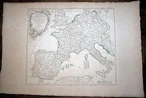
Ajouter au panierPas de couverture. Etat : Bon. Carte gravée originale portant au verso le N. 12 provenant de l'atlas publié par Robert de Vaugondy; bon état général de la carte, pratiquement sans tâches du côté de la gravure, avec une infime perforation, pratiquement invisible, au milieu ŕ l'endroit de la pliure; dimensions de la feuille: 68,5X50; dimensions de la gravure: 55X47,5; le contour de l'Empire de Charlemagne est marqué en vert; bon exemplaire;
-
Imperium Caroli Magni. Occidentis Imperatoris / Map
Edité par 1752, 1752
Vendeur : DR Fine Arts, New York, NY, Etats-Unis
Évaluation du vendeur 4 sur 5 étoiles

Edition originale
EUR 219,98
Autre deviseEUR 41,86 expédition depuis Etats-Unis vers FranceQuantité disponible : 1 disponible(s)
Ajouter au panierNo Binding. Etat : Good. 1st Edition. Dated 1752; covers the Impire of Caroli Magni; some text: "usque Marc Balticum, protenditur"." cum privilegio"'; text in Latin: map show the England, Germany, France, Spain, top of Africa, some of Turkey and more, during Caroli Magni period; folded / attached in the middle and the back it has print the number 12, so apparently this was a print/map from a book; paper size: 33 x 23in, image size: 22 x 19 in; the paper has an invisible water mark in the hand made paper; there is green borders for the Impire, Spain would have been Moslum at the time; a little rubbing and just a little foxing and a tiny spot in margins; just a little normal browning to all the map; overall the map is in GOOD COND.
-

Imperium Caroli Magni Occidentis Imperatoris complectens Galliam, Marcam Hispanicam, Baleares insulas Corsicam Italiam Valturnum usque et Aufidum fluv? Instriam, Liburniam, Dalmatiam, Rhaetiam, Vindeliciam, Noricum, et quidquid Germaniae ŕ Rheno ad Oderam usque et Mare Balticum, protenditure Autore D.Robert de Vaugondy Geographo Regis Ordinario Cum privilegio
Date d'édition : 1752
Vendeur : Antiqua Print Gallery, London, Royaume-Uni
Évaluation du vendeur 3 sur 5 étoiles

Carte
EUR 117,96
Autre deviseEUR 12,60 expédition depuis Royaume-Uni vers FranceQuantité disponible : 1 disponible(s)
Ajouter au panierEtat : Good. "Imperium Caroli Magni" Western Europe. Carolingian Empire. VAUGONDY 1752 map. Large antique 18th century atlas map, printed on thick, good quality paper with original outline hand colour/color and decorative title cartouche; Robert de Vaugondy, Gilles & Didier (1752). 49.5 x 58.0cm, 19.5 x 22.75 inches; this is a folding map. Condition: Good. There is nothing printed on the reverse side, which is plain.".
-
Imperium Caroli Magni Occidentis Imperatoris
Date d'édition : 1752
Vendeur : Argosy Book Store, ABAA, ILAB, New York, NY, Etats-Unis
Membre d'association : ABAA ILAB
Évaluation du vendeur 5 sur 5 étoiles

EUR 241,98
Autre deviseEUR 35,88 expédition depuis Etats-Unis vers FranceQuantité disponible : 1 disponible(s)
Ajouter au panierMap. Engraving with original hand coloring. Image measures 19" x 22" Detailed map from 1752 showing Charlemagne's empire. Charlemagne ruled the Carolingian empire from the years 800 to 814. His empire, demarcated with hand colored green outline, included modern-day France, Belgium, Germany, the Netherlands, Switzerland, Austria, northern Italy, northeastern Spain, and the Dalmatian coast. Extends from the Iberian peninsula to the Carpathian Mountains, including the western Mediterranean, the northern coast of Africa, England and Wales. This map is in very good condition. Minor toning and fraying at edges, not affecting the image. One small spot along centerfold. Didier Robert de Vaugondy (1723-1786) was the son of Gilles, an important French mapmaker during the 18th century. Together they published "Atlas Universel", one of the most significant atlases of the period, integrating older sources with more modern surveyed maps in order to convey correct geographical and political information. Didier carried on his father's impressive work, becoming highly regarded for his globemaking.