Montant total (1 article articles) :
Destination de la commande :

india inset map calcutta de bartholomew john (5 rÈsultats)
Commentaires
Passer aux rÈsultats principaux de la recherche
Filtres de recherche
Type d'article
- Tous les types de produits
- Livres (3)
- Magazines & PÈriodiques (Aucun autre rÈsultat ne correspond ‡ ces critËres)
- Bandes dessinÈes (Aucun autre rÈsultat ne correspond ‡ ces critËres)
- Partitions de musique (Aucun autre rÈsultat ne correspond ‡ ces critËres)
- Art, Affiches et Gravures (Aucun autre rÈsultat ne correspond ‡ ces critËres)
- Photographies (Aucun autre rÈsultat ne correspond ‡ ces critËres)
- Cartes (2)
- Manuscrits & Papiers anciens (Aucun autre rÈsultat ne correspond ‡ ces critËres)
Etat En savoir plus
- Neuf (Aucun autre rÈsultat ne correspond ‡ ces critËres)
- Comme neuf, TrËs bon ou Bon (Aucun autre rÈsultat ne correspond ‡ ces critËres)
- Assez bon ou satisfaisant (3)
- Moyen ou mauvais (Aucun autre rÈsultat ne correspond ‡ ces critËres)
- ConformÈment ‡ la description (2)
Reliure
- Toutes
- Couverture rigide (Aucun autre rÈsultat ne correspond ‡ ces critËres)
- Couverture souple (1)
ParticularitÈs
- Ed. originale (1)
- SignÈ (Aucun autre rÈsultat ne correspond ‡ ces critËres)
- Jaquette (Aucun autre rÈsultat ne correspond ‡ ces critËres)
- Avec images (5)
- Sans impressions ‡ la demande (5)
Langue (1)
Prix
- Tous les prix
- Moins de EUR 20
- EUR 20 ‡ EUR 45
- Plus de EUR 45 (Aucun autre rÈsultat ne correspond ‡ ces critËres)
Livraison gratuite
- Livraison gratuite ‡ destination de France (Aucun autre rÈsultat ne correspond ‡ ces critËres)
Pays
Evaluation du vendeur
-
India Eastern section Inset map of Calcutta
Vendeur : Antiqua Print Gallery, London, Royaume-Uni
…valuation du vendeur 3 sur 5 Ètoiles

EUR 10,03
Autre deviseEUR 12,60 expÈdition depuis Royaume-Uni vers FranceQuantitÈ disponible : 1 disponible(s)
Ajouter au panier -
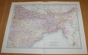
Map of India (Section 2) covering parts of modern day central and eastern India, Bangladesh, Bhutan and Nepal with small inset plan of Calcutta - Sheet 47 Disbound from the 1890 'The Library Reference Atlas of the World'
EditÈ par Macmillan and Co., London, 1890
Vendeur : Bailgate Books Ltd, Doncaster, Royaume-Uni
…valuation du vendeur 5 sur 5 Ètoiles

Edition originale
EUR 37,76
Autre deviseEUR 9,16 expÈdition depuis Royaume-Uni vers FranceQuantitÈ disponible : 1 disponible(s)
Ajouter au panierSoftcover. Etat : Very Good. Etat de la jaquette : No Dust Jacket. First Edition. Single disbound coloured map sheet from John Bartholomew's Library Reference Atlas. Section 2 only of 3 covering India (as was in 1890). Approx size 35 x 46 cm, vertical centre fold. Corners lightly worn. Map is clean, crisp, clear and bright. Sheet covers parts of modern day eastern India, Bangladesh, Bhutan and part of Nepal including: Lucknow, Patna, Allahabad, Narsinghpur, Bandara, Kanker, Lahara, Sambalpur, Bhagalpur, Bengal, Chutia Nagpur, Jashpur, Calcutta, Assam, Sikkim, Lakhimpur, Manipur, Chittagong, Dacca, Khatmandu, Punakha, etc. Small inset plan of Calcutta in lower right corner of sheet. No dust jacket, as published. Quantity Available: 1. Shipped Weight: under 1 kg. Pictures of this item not already displayed here available upon request. Inventory No: 45020124016. All our books are sent by tracked mail.
-
India - Northern Section; Inset map of Howrah Calcutta
Date d'Èdition : 1900
Vendeur : Antiqua Print Gallery, London, Royaume-Uni
…valuation du vendeur 3 sur 5 Ètoiles
Carte
EUR 15,34
Autre deviseEUR 12,60 expÈdition depuis Royaume-Uni vers FranceQuantitÈ disponible : 1 disponible(s)
Ajouter au panierEtat : Good. INDIA. North; Howrah Kolkata 1900 old antique vintage map plan chart. Colour antique map; John Bartholomew & Co. (1900). 23.0 x 31.5cm, 9 x 12.5 inches. Condition: Good. There are images and/or text printed on the reverse side of the picture. In some cases this may be visible on the picture itself or around the margin of the picture.
-
India Section 2 Inset map of Calcutta
Vendeur : Antiqua Print Gallery, London, Royaume-Uni
…valuation du vendeur 3 sur 5 Ètoiles
EUR 18,88
Autre deviseEUR 12,60 expÈdition depuis Royaume-Uni vers FranceQuantitÈ disponible : 1 disponible(s)
Ajouter au panier -
India (Section 2); Inset map of Calcutta
Date d'Èdition : 1912
Vendeur : Antiqua Print Gallery, London, Royaume-Uni
…valuation du vendeur 3 sur 5 Ètoiles
Carte
EUR 28,32
Autre deviseEUR 12,60 expÈdition depuis Royaume-Uni vers FranceQuantitÈ disponible : 2 disponible(s)
Ajouter au panierEtat : Good. BRITISH INDIA NORTH EAST. Bengal Assam Nepal Bhutan Orissa. Calcutta 1912 map. Antique colour atlas map; John Bartholomew & Co., Edin. (1912). 34.0 x 44.0cm, 13.25 x 17.5 inches; this is a folding map. Condition: Good. There is nothing printed on the reverse side, which is plain.