Montant total (1 article articles) :
Destination de la commande :

kent 1797 original antique map de edward hasted (5 rÈsultats)
Commentaires
Passer aux rÈsultats principaux de la recherche
Filtres de recherche
Type d'article
- Tous les types de produits
- Livres (Aucun autre rÈsultat ne correspond ‡ ces critËres)
- Magazines & PÈriodiques (Aucun autre rÈsultat ne correspond ‡ ces critËres)
- Bandes dessinÈes (Aucun autre rÈsultat ne correspond ‡ ces critËres)
- Partitions de musique (Aucun autre rÈsultat ne correspond ‡ ces critËres)
- Art, Affiches et Gravures (Aucun autre rÈsultat ne correspond ‡ ces critËres)
- Photographies (Aucun autre rÈsultat ne correspond ‡ ces critËres)
- Cartes (5)
- Manuscrits & Papiers anciens (Aucun autre rÈsultat ne correspond ‡ ces critËres)
Etat En savoir plus
- Neuf (Aucun autre rÈsultat ne correspond ‡ ces critËres)
- Comme neuf, TrËs bon ou Bon (Aucun autre rÈsultat ne correspond ‡ ces critËres)
- Assez bon ou satisfaisant (5)
- Moyen ou mauvais (Aucun autre rÈsultat ne correspond ‡ ces critËres)
- ConformÈment ‡ la description (Aucun autre rÈsultat ne correspond ‡ ces critËres)
Reliure
- Toutes
- Couverture rigide (Aucun autre rÈsultat ne correspond ‡ ces critËres)
- Couverture souple (Aucun autre rÈsultat ne correspond ‡ ces critËres)
ParticularitÈs
- Ed. originale (Aucun autre rÈsultat ne correspond ‡ ces critËres)
- SignÈ (Aucun autre rÈsultat ne correspond ‡ ces critËres)
- Jaquette (Aucun autre rÈsultat ne correspond ‡ ces critËres)
- Avec images (5)
- Sans impressions ‡ la demande (5)
Langue (1)
Prix
- Tous les prix
- Moins de EUR 20 (Aucun autre rÈsultat ne correspond ‡ ces critËres)
- EUR 20 ‡ EUR 45 (Aucun autre rÈsultat ne correspond ‡ ces critËres)
- Plus de EUR 45
Livraison gratuite
- Livraison gratuite ‡ destination de France (Aucun autre rÈsultat ne correspond ‡ ces critËres)
Pays
Evaluation du vendeur
-
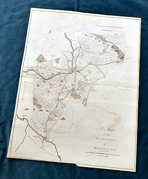
KENT, 1797 - ORIGINAL ANTIQUE MAP of Hundred of MAIDSTONE - HASTED.
EditÈ par Bayly Sculp , London / W Bristow, Canterbury., 1797
Vendeur : End of The World Maps., Penzance, Royaume-Uni
…valuation du vendeur 5 sur 5 Ètoiles

Carte
EUR 70,87
Autre deviseEUR 10,32 expÈdition depuis Royaume-Uni vers FranceQuantitÈ disponible : 1 disponible(s)
Ajouter au panierNo Binding. Etat : Very Good. KENT, 1797 - ORIGINAL ANTIQUE MAP of Hundreds of MAIDSTONE - HASTED. A large Original Antique 18th Century copperplate map in it's original, non-coloured state, in VERY GOOD CONDITION - suitable for framing. A `Hundred' stems from Anglo-Saxon when the community was made up of `tithes' (a ten household unit), which was responsible to the `Hundred Court' (normally consisting of ten ` tithes'), and `lathes' (into which the Hundreds were grouped). PROVENANCE: The History and Topographical Survey of The County of Kent by Edward Hasted. Published by W Bristow , The Parade, Canterbury. PRINTED IN : 1797 (2nd Edition). PRINTED by : J Bayly Sculp, London MAP PRINT AREA: 47 x 37 cm, (18.5 x 14.5 inches). SCALE : 1 inch per mile. VERSO: There are no images and/or text printed on the reverse side . CONDITION: Large sheet map , in original non-coloured condition. Centre fold , with usual remains of mounting guide to rear. Light remains of original folds. Normal aging / handling marks to margins consistent with light usage only. Some minor offsetting and wear to edges, but the printed area is well preserved. Small archival repair to bottom of centrefold, no loss. ( please study photographs to appreciate the good condition this map is in. ) Important Note : Virtually all antiquarian maps and prints are subject to some normal aging due to use and time which is not obtrusive unless otherwise stated. Please note the listing includes the map as described only , any reference / photo of the book the map has been sourced from is for information only. DECLARATION OF AUTHENTICITY: We guarantee the map to be an authentic map published at the date stated above. We do not sell reproductions. THIS MAP IS ACCOMPANIED BY A CERTIFICATE of AUTHENTICITY.
-
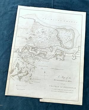
KENT, 1797 - ORIGINAL ANTIQUE MAP of Hundreds of CHATHAM & GILLINGHAM covering the area between Chatham, Gillingham, High Halstead and The Isle of Grain - HASTED.
EditÈ par Bayly Sculp , London / W Bristow, Canterbury., 1797
Vendeur : End of The World Maps., Penzance, Royaume-Uni
…valuation du vendeur 5 sur 5 Ètoiles
Carte
EUR 70,87
Autre deviseEUR 10,32 expÈdition depuis Royaume-Uni vers FranceQuantitÈ disponible : 1 disponible(s)
Ajouter au panierNo Binding. Etat : Very Good. KENT, 1797 - ORIGINAL ANTIQUE MAP of Hundreds of CHATHAM & GILLINGHAM covering the area between Chatham, Gillingham, High Halstead and The Isle of Grain, in Very Good condition - HASTED. A large Original Antique 18th Century copperplate map in it's original, non-coloured state, in VERY GOOD CONDITION - suitable for framing. A `Hundred' stems from Anglo-Saxon when the community was made up of `tithes' (a ten household unit), which was responsible to the `Hundred Court' (normally consisting of ten ` tithes'), and `lathes' (into which the Hundreds were grouped). PROVENANCE: The History and Topographical Survey of The County of Kent by Edward Hasted. Published by W Bristow , The Parade, Canterbury. PRINTED IN : 1797 (2nd Edition). PRINTED by : J Bayly Sculp, London MAP PRINT AREA: 37 x 37 cm, (18.5 x 14.5 inches). SCALE : 1 inch per mile. VERSO: There are no images and/or text printed on the reverse side . CONDITION: Large sheet map , in original non-coloured condition. Centre fold , with usual remains of mounting guide to rear. Light remains of original folds. Normal aging / handling marks to margins consistent with light usage only. Some very minor offsetting and wear to edges, but the printed area is well preserved. Small archival repair to bottom of centrefold, no loss. ( please study photographs to appreciate the good condition this map is in. ) Important Note : Virtually all antiquarian maps and prints are subject to some normal aging due to use and time which is not obtrusive unless otherwise stated. Please note the listing includes the map as described only , any reference / photo of the book the map has been sourced from is for information only. DECLARATION OF AUTHENTICITY: We guarantee the map to be an authentic map published at the date stated above. We do not sell reproductions. THIS MAP IS ACCOMPANIED BY A CERTIFICATE of AUTHENTICITY.
-
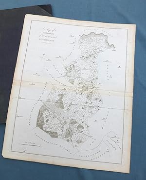
KENT, 1797 - Hundreds of WINGHAM & KINGHAMFORD, Original Antique Map - HASTED, showing the area between ASH, WINGHAM, KINGSTON & BARHAM.
EditÈ par Bayly Sculp , London / W Bristow, Canterbury., 1797
Vendeur : End of The World Maps., Penzance, Royaume-Uni
…valuation du vendeur 5 sur 5 Ètoiles
Carte
EUR 70,87
Autre deviseEUR 10,32 expÈdition depuis Royaume-Uni vers FranceQuantitÈ disponible : 1 disponible(s)
Ajouter au panierNo Binding. Etat : Very Good. KENT, 1797 - Hundreds of WINGHAM & KINGHAMFORD, Original Antique Map - HASTED, showing the area between ASH, WINGHAM, KINGSTON & BARHAM. A large Original Antique 18th Century copperplate map in it's original, non-coloured state, in VERY GOOD CONDITION - suitable for framing. A `Hundred' stems from Anglo-Saxon when the community was made up of `tithes' (a ten household unit), which was responsible to the `Hundred Court' (normally consisting of ten ` tithes'), and `lathes' (into which the Hundreds were grouped). PROVENANCE: The History and Topographical Survey of The County of Kent by Edward Hasted. Published by W Bristow , The Parade, Canterbury. PRINTED IN : 1797 (2nd Edition). PRINTED by : J Bayly Sculp, London MAP PRINT AREA: 47 x 37 cm, (18.5 x 14.5 inches). SCALE : 1 inch per mile. VERSO: There are no images and/or text printed on the reverse side . CONDITION: Large sheet map , in original non-coloured condition. Centre fold , with usual remains of mounting guide to rear. Light remains of original folds. Normal aging / handling marks to margins consistent with light usage only. Some very minor offsetting and wear to edges, but the printed area is well preserved. Small archival repair to bottom of centrefold, no loss. ( please study photographs to appreciate the good condition this map is in. ) Important Note : Virtually all antiquarian maps and prints are subject to some normal aging due to use and time which is not obtrusive unless otherwise stated. Please note the listing includes the map as described only , any reference / photo of the book the map has been sourced from is for information only. DECLARATION OF AUTHENTICITY: We guarantee the map to be an authentic map published at the date stated above. We do not sell reproductions. THIS MAP IS ACCOMPANIED BY A CERTIFICATE of AUTHENTICITY.
-
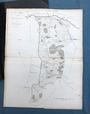
KENT, 1797 - Hundreds of MARDEN , GOUDHURST, Original Antique Map - HASTED, showing the area between GOUDHURST, STAPLEHURST & MARDEN
EditÈ par Bayly Sculp , London / W Bristow, Canterbury., 1797
Vendeur : End of The World Maps., Penzance, Royaume-Uni
…valuation du vendeur 5 sur 5 Ètoiles
Carte
EUR 70,87
Autre deviseEUR 10,32 expÈdition depuis Royaume-Uni vers FranceQuantitÈ disponible : 1 disponible(s)
Ajouter au panierNo Binding. Etat : Very Good. KENT, 1797 - Hundred of MARDEN , GOUDHURST, Original Antique Map - HASTED, showing the area between GOUDHURST, STAPLEHURST & MARDEN A large Original Antique 18th Century copperplate map in it's original, non-coloured state, in VERY GOOD CONDITION - suitable for framing. A `Hundred' stems from Anglo-Saxon when the community was made up of `tithes' (a ten household unit), which was responsible to the `Hundred Court' (normally consisting of ten ` tithes'), and `lathes' (into which the Hundreds were grouped). PROVENANCE: The History and Topographical Survey of The County of Kent by Edward Hasted. Published by W Bristow , The Parade, Canterbury. PRINTED IN : 1797 (2nd Edition). PRINTED by : J Bayly Sculp, London MAP PRINT AREA: 47 x 37 cm, (18.5 x 14.5 inches). SCALE : 1 inch per mile. VERSO: There are no images and/or text printed on the reverse side . CONDITION: Large sheet map , in original non-coloured condition. Centre fold , with usual remains of mounting guide to rear. Light remains of original folds. Normal aging / handling marks to margins consistent with light usage only. Some very minor offsetting and wear to edges, but the printed area is well preserved. Small archival repair to bottom of centrefold, no loss. ( please study photographs to appreciate the good condition this map is in. ) Important Note : Virtually all antiquarian maps and prints are subject to some normal aging due to use and time which is not obtrusive unless otherwise stated. Please note the listing includes the map as described only , any reference / photo of the book the map has been sourced from is for information only. DECLARATION OF AUTHENTICITY: We guarantee the map to be an authentic map published at the date stated above. We do not sell reproductions. THIS MAP IS ACCOMPANIED BY A CERTIFICATE of AUTHENTICITY.
-
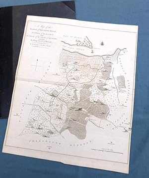
KENT, 1797 - Hundred of BOUGHTON BLEAN, SEASALTER, Original Antique Map - HASTED
EditÈ par Bayly Sculp , London / W Bristow, Canterbury., 1797
Vendeur : End of The World Maps., Penzance, Royaume-Uni
…valuation du vendeur 5 sur 5 Ètoiles
Carte
EUR 70,87
Autre deviseEUR 10,32 expÈdition depuis Royaume-Uni vers FranceQuantitÈ disponible : 1 disponible(s)
Ajouter au panierNo Binding. Etat : Very Good. KENT, 1797 - Hundred of BOUGHTON BLEAN, SEASALTER, Original Antique Map - HASTED A large Original Antique 18th Century copperplate map in it's original, non-coloured state, in VERY GOOD CONDITION - suitable for framing. A `Hundred' stems from Anglo-Saxon when the community was made up of `tithes' (a ten household unit), which was responsible to the `Hundred Court' (normally consisting of ten ` tithes'), and `lathes' (into which the Hundreds were grouped). PROVENANCE: The History and Topographical Survey of The County of Kent by Edward Hasted. Published by W Bristow , The Parade, Canterbury. PRINTED IN : 1797 (2nd Edition). PRINTED by : J Bayly Sculp, London MAP PRINT AREA: 47 x 37 cm, (18.5 x 14.5 inches). SCALE : 1 inch per mile. VERSO: There are no images and/or text printed on the reverse side . CONDITION: Large sheet map , in original non-coloured condition. Centre fold , with usual remains of mounting guide to rear. Light remains of original folds. Normal aging / handling marks to margins consistent with light usage only. Some very minor offsetting and wear to edges, but the printed area is well preserved. Small archival repair to bottom of centrefold, no loss. ( please study photographs to appreciate the good condition this map is in. ) Important Note : Virtually all antiquarian maps and prints are subject to some normal aging due to use and time which is not obtrusive unless otherwise stated. Please note the listing includes the map as described only , any reference / photo of the book the map has been sourced from is for information only. DECLARATION OF AUTHENTICITY: We guarantee the map to be an authentic map published at the date stated above. We do not sell reproductions. THIS MAP IS ACCOMPANIED BY A CERTIFICATE of AUTHENTICITY.