Montant total (1 article articles) :
Destination de la commande :

langleterre divisée grandes parties subdivisées de brion tour desnos louis (2 résultats)
Commentaires
Passer aux résultats principaux de la recherche
Filtres de recherche
Type d'article
- Tous les types de produits
- Livres (Aucun autre résultat ne correspond ŕ ces critčres)
- Magazines & Périodiques (Aucun autre résultat ne correspond ŕ ces critčres)
- Bandes dessinées (Aucun autre résultat ne correspond ŕ ces critčres)
- Partitions de musique (Aucun autre résultat ne correspond ŕ ces critčres)
- Art, Affiches et Gravures (Aucun autre résultat ne correspond ŕ ces critčres)
- Photographies (Aucun autre résultat ne correspond ŕ ces critčres)
- Cartes (2)
- Manuscrits & Papiers anciens (Aucun autre résultat ne correspond ŕ ces critčres)
Etat En savoir plus
- Neuf (Aucun autre résultat ne correspond ŕ ces critčres)
- Comme neuf, Trčs bon ou Bon (Aucun autre résultat ne correspond ŕ ces critčres)
- Assez bon ou satisfaisant (1)
- Moyen ou mauvais (Aucun autre résultat ne correspond ŕ ces critčres)
- Conformément ŕ la description (1)
Reliure
- Toutes
- Couverture rigide (Aucun autre résultat ne correspond ŕ ces critčres)
- Couverture souple (Aucun autre résultat ne correspond ŕ ces critčres)
Particularités
- Ed. originale (Aucun autre résultat ne correspond ŕ ces critčres)
- Signé (Aucun autre résultat ne correspond ŕ ces critčres)
- Jaquette (Aucun autre résultat ne correspond ŕ ces critčres)
- Avec images (1)
- Sans impressions ŕ la demande (2)
Langue (1)
Prix
- Tous les prix
- Moins de EUR 20 (Aucun autre résultat ne correspond ŕ ces critčres)
- EUR 20 ŕ EUR 45
- Plus de EUR 45
Livraison gratuite
- Livraison gratuite ŕ destination de Etats-Unis (Aucun autre résultat ne correspond ŕ ces critčres)
Pays
Evaluation du vendeur
-
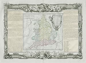
L'Angleterre divisée en 5 grandes parties subdivisées en 52 comtes; et partagée en 2 Provinces Ecclésiastiques d'aprčs les Auteurs Anglois et des connoissances prises sur les lieux: Par Mr. Brion, Ingénieur-Géographe du Roi. ŕ Paris, chez le Sr. Desnos, Ingénieur Géograph pour les Globes et Sphéres, ruë St. Jacques, au Globe. Avec privilčge du Roi 1766
Date d'édition : 1771
Vendeur : Antiqua Print Gallery, London, Royaume-Uni
Évaluation du vendeur 3 sur 5 étoiles

Carte
EUR 40,21
Autre deviseEUR 11,48 expédition depuis Royaume-Uni vers Etats-UnisQuantité disponible : 1 disponible(s)
Ajouter au panierEtat : Good. "L'Angleterre divisée en 5 grandes parties". England. DESNOS/DE LA TOUR 1771 map. Antique eighteenth century copperplate atlas map with original hand colour, and ornate border. The flanking columns of descriptive text were stuck onto the sheet at the time of publication; Louis Brion de la Tour / Louis Desnos (1771). 56.5 x 44.0cm, 22.25 x 17.25 inches; this is a folding map. Condition: Good. There is nothing printed on the reverse side, which is plain. England, unusually divided into 5 major parts.
-

L'Angleterre divisée en 5. grandes Parties, subdivisées en 52. Comtés.
Edité par Paris, 1766
Vendeur : Libreria Ex Libris ALAI-ILAB/LILA member, Roma, RM, Italie
Membre d'association : ALAI ILAB
Évaluation du vendeur 5 sur 5 étoiles

Carte
EUR 140
Autre deviseEUR 30 expédition depuis Italie vers Etats-UnisQuantité disponible : 1 disponible(s)
Ajouter au panierIncisione originale su rame (cm. 25,5x23 piů testo laterale e margini bianchi). Coloritura coeva all'acquerello. Ottimo esemplare.