
Montant total (1 article articles) :
Destination de la commande :

large hand coloured geological ordnance de ordnance survey (6 résultats)
Commentaires
Passer aux résultats principaux de la recherche
Filtres de recherche
Type d'article
- Tous les types de produits
- Livres (6)
- Magazines & Périodiques (Aucun autre résultat ne correspond ŕ ces critčres)
- Bandes dessinées (Aucun autre résultat ne correspond ŕ ces critčres)
- Partitions de musique (Aucun autre résultat ne correspond ŕ ces critčres)
- Art, Affiches et Gravures (Aucun autre résultat ne correspond ŕ ces critčres)
- Photographies (Aucun autre résultat ne correspond ŕ ces critčres)
- Cartes (Aucun autre résultat ne correspond ŕ ces critčres)
- Manuscrits & Papiers anciens (Aucun autre résultat ne correspond ŕ ces critčres)
Etat En savoir plus
- Neuf (Aucun autre résultat ne correspond ŕ ces critčres)
- Comme neuf, Trčs bon ou Bon (Aucun autre résultat ne correspond ŕ ces critčres)
- Assez bon ou satisfaisant (Aucun autre résultat ne correspond ŕ ces critčres)
- Moyen ou mauvais (Aucun autre résultat ne correspond ŕ ces critčres)
- Conformément ŕ la description (6)
Reliure
- Toutes
- Couverture rigide (Aucun autre résultat ne correspond ŕ ces critčres)
- Couverture souple (Aucun autre résultat ne correspond ŕ ces critčres)
Particularités
- Ed. originale (Aucun autre résultat ne correspond ŕ ces critčres)
- Signé (Aucun autre résultat ne correspond ŕ ces critčres)
- Jaquette (Aucun autre résultat ne correspond ŕ ces critčres)
- Avec images (6)
- Sans impressions ŕ la demande (6)
Langue (1)
Prix
- Tous les prix
- Moins de EUR 20 (Aucun autre résultat ne correspond ŕ ces critčres)
- EUR 20 ŕ EUR 45
- Plus de EUR 45
Livraison gratuite
- Livraison gratuite ŕ destination de France (Aucun autre résultat ne correspond ŕ ces critčres)
Pays
Evaluation du vendeur
-
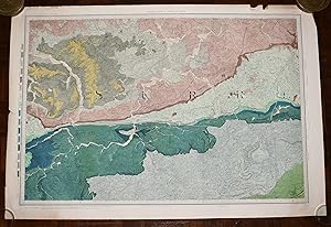
Large Hand Coloured Geological Ordnance Survey MAP SHEET 12 Basingstoke Hampshire Geological Survey of England & Wales Scale 1 inch to 1 mile.
Edité par Geological Survey of England & Wales Colonel Colby 1860 Revised 1885, 1885
Vendeur : PROCTOR / THE ANTIQUE MAP & BOOKSHOP, DORCHESTER, Royaume-Uni
Membre d'association : PBFA
Évaluation du vendeur 5 sur 5 étoiles

EUR 23,59
Autre deviseEUR 12,54 expédition depuis Royaume-Uni vers FranceQuantité disponible : 1 disponible(s)
Ajouter au panierOriginal rolled flat map. Hand-coloured engraving With ORDNANCE SURVEY Blind Stamp top margin. Size 33.5 inches X 26.5 inches. 84cm x 66cm Ordnance survey map showing Basingstoke, Whitchurch, Andover & surrounding areas. In good condition. Some foxing & a little dusty on margins & tear on right hand side of map. A few small nicks top edge. Unfolded. It will be rolled up and posted in a poster tube.
-

Large Hand Coloured Geological Ordnance Survey MAP SHEET 47 S.W Essex Geological Survey of England & Wales Scale 1 inch to 1 mile.
Edité par Geological Survey of England & Wales 1884, 1884
Vendeur : PROCTOR / THE ANTIQUE MAP & BOOKSHOP, DORCHESTER, Royaume-Uni
Membre d'association : PBFA
Évaluation du vendeur 5 sur 5 étoiles
EUR 25,95
Autre deviseEUR 12,54 expédition depuis Royaume-Uni vers FranceQuantité disponible : 1 disponible(s)
Ajouter au panierOriginal rolled flat map. Hand-coloured engraving With ORDNANCE SURVEY Blind Stamp top margin. Size 40 inches X 26.5 inches. 100cm x 68cm Ordnance survey map showing Saffron Walden, Whitham, Royston & surrounding areas. In generally good condition. Some foxing & a little dusty on margins & right hand side. A few small nicks on edges, a little tatty top left corner. Unfolded. It will be rolled up and posted in a poster tube.
-
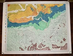
Large Hand Coloured Geological Ordnance Survey MAP SHEET 8 Guildford SURREY Geological Survey of England & Wales Scale 1 inch to 1 mile.
Edité par Geological Survey of England & Wales Colonel Colby 1816 Revised 1891, 1891
Vendeur : PROCTOR / THE ANTIQUE MAP & BOOKSHOP, DORCHESTER, Royaume-Uni
Membre d'association : PBFA
Évaluation du vendeur 5 sur 5 étoiles
EUR 33,03
Autre deviseEUR 12,54 expédition depuis Royaume-Uni vers FranceQuantité disponible : 1 disponible(s)
Ajouter au panierOriginal rolled flat map. Hand-coloured engraving With ORDNANCE SURVEY Blind Stamp top margin. Size 33.5 inches X 26 inches. 85cm x 66cm Ordnance survey map showing Guildford & surrounding areas. In good condition. Some foxing & a little dusty on margins. Margin has small tear on left, crease down right hand margin, Top edge a little nicked with one tear. MAP not affected by edge nicks etc. Unfolded. It will be rolled up and posted in a poster tube.
-

Large Hand Coloured Geological Ordnance Survey MAP SHEET 12 Basingstoke Hampshire Geological Survey of England & Wales Scale 1 inch to 1 mile.
Edité par Geological Survey of England & Wales Colonel Colby 1860 Revised 1885, 1885
Vendeur : PROCTOR / THE ANTIQUE MAP & BOOKSHOP, DORCHESTER, Royaume-Uni
Membre d'association : PBFA
Évaluation du vendeur 5 sur 5 étoiles
EUR 38,93
Autre deviseEUR 12,54 expédition depuis Royaume-Uni vers FranceQuantité disponible : 1 disponible(s)
Ajouter au panierOriginal rolled flat map. Hand-coloured engraving With ORDNANCE SURVEY Blind Stamp top margin. Size 32.5 inches X 27.5 inches. 82cm x 70cm Ordnance survey map showing Basingstoke, Whitchurch, Andover & surrounding areas. In good condition. Some foxing & a little dusty on margins & slightly on right hand side of map. A few small nicks lower edge. Unfolded. It will be rolled up and posted in a poster tube.
-

Large Hand Coloured Geological Ordnance Survey MAP SHEET 7 LONDON including River Thames Middlesex Geological Survey of England & Wales Scale 1 inch to 1 mile.
Edité par Geological Survey of England & Wales Colonel Colby 1822 Revised 1885, 1885
Vendeur : PROCTOR / THE ANTIQUE MAP & BOOKSHOP, DORCHESTER, Royaume-Uni
Membre d'association : PBFA
Évaluation du vendeur 5 sur 5 étoiles
EUR 64,88
Autre deviseEUR 12,54 expédition depuis Royaume-Uni vers FranceQuantité disponible : 1 disponible(s)
Ajouter au panierOriginal rolled flat map. Hand-coloured engraving With ORDNANCE SURVEY Blind Stamp top margin. Size 39.5 inches X 27 inches. 100cm x 69cm Ordnance survey map showing Uxbridge, Windsor, Watford Chelsea & surrounding areas. In generally good condition. Some foxing & a little dusty on margins & 2 tears together on top edge of map. A few small nicks on edges. Unfolded. It will be rolled up and posted in a poster tube.
-
Large Hand Coloured Geological Ordnance Survey MAP SHEET 13 OXFORD, OXFORDSHIRE Geological Survey of England & Wales Scale 1 inch to 1 mile.
Edité par Geological Survey of England & Wales Colonel Colby 1830 Revised 1891, 1891
Vendeur : PROCTOR / THE ANTIQUE MAP & BOOKSHOP, DORCHESTER, Royaume-Uni
Membre d'association : PBFA
Évaluation du vendeur 5 sur 5 étoiles
EUR 64,88
Autre deviseEUR 12,54 expédition depuis Royaume-Uni vers FranceQuantité disponible : 1 disponible(s)
Ajouter au panierOriginal rolled flat map. Hand-coloured engraving With ORDNANCE SURVEY Blind Stamp top margin. Size 33.5 inches X 26 inches. 85cm x 66cm Ordnance survey map showing areas Abingdon, Oxford, Chilton. In very good condition. Some foxing & a little dusty on margins. Unfolded. It will be rolled up and posted in a poster tube.
