
Montant total (1 article articles) :
Destination de la commande :

lasie divisé letendue empires royaumes de bailleul (1 résultats)
Commentaires
Passer aux résultats principaux de la recherche
Filtres de recherche
Type d'article
- Tous les types de produits
- Livres (Aucun autre résultat ne correspond ŕ ces critčres)
- Magazines & Périodiques (Aucun autre résultat ne correspond ŕ ces critčres)
- Bandes dessinées (Aucun autre résultat ne correspond ŕ ces critčres)
- Partitions de musique (Aucun autre résultat ne correspond ŕ ces critčres)
- Art, Affiches et Gravures (Aucun autre résultat ne correspond ŕ ces critčres)
- Photographies (Aucun autre résultat ne correspond ŕ ces critčres)
- Cartes (1)
- Manuscrits & Papiers anciens (Aucun autre résultat ne correspond ŕ ces critčres)
Etat En savoir plus
- Neuf (Aucun autre résultat ne correspond ŕ ces critčres)
- Comme neuf, Trčs bon ou Bon (Aucun autre résultat ne correspond ŕ ces critčres)
- Assez bon ou satisfaisant (Aucun autre résultat ne correspond ŕ ces critčres)
- Moyen ou mauvais (Aucun autre résultat ne correspond ŕ ces critčres)
- Conformément ŕ la description (1)
Reliure
- Toutes
- Couverture rigide (Aucun autre résultat ne correspond ŕ ces critčres)
- Couverture souple (Aucun autre résultat ne correspond ŕ ces critčres)
Particularités
- Ed. originale (Aucun autre résultat ne correspond ŕ ces critčres)
- Signé (Aucun autre résultat ne correspond ŕ ces critčres)
- Jaquette (Aucun autre résultat ne correspond ŕ ces critčres)
- Avec images (1)
- Sans impressions ŕ la demande (1)
Langue (1)
Prix
- Tous les prix
- Moins de EUR 20 (Aucun autre résultat ne correspond ŕ ces critčres)
- EUR 20 ŕ EUR 40 (Aucun autre résultat ne correspond ŕ ces critčres)
- Plus de EUR 40
Livraison gratuite
- Livraison gratuite ŕ destination de France (Aucun autre résultat ne correspond ŕ ces critčres)
Pays
Evaluation du vendeur
-
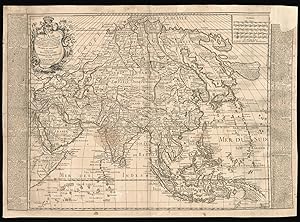
L'Asie divisé suivant l'etendue des Empires et Royaumes qui la partagent Et des dominations établies par les Castillans les Portugais les François et les Hollandois avec des Nottes Historiques et Géographiques Extraitz de la Martinier et autres Autheurs. Dédiée et Presentée a Messire Betrand René Pallu Intendant de la Ville Généralité de Lyon.
Edité par Daudet, rue Merciere,, Lyon,, 1748
Vendeur : Daniel Crouch Rare Books Ltd, London, Royaume-Uni
Membre d'association : ABA ILAB PBFA
Évaluation du vendeur 4 sur 5 étoiles

Carte
EUR 7 077,29
Autre deviseEUR 17,18 expédition depuis Royaume-Uni vers FranceQuantité disponible : 1 disponible(s)
Ajouter au panierA rare map of Asia showing the Sea of Korea Engraved map, border text on the sides, some original outline colour, top right corner missing and affecting the text, skilfuly repaired. The map covers the entire Asian continent, stretching from Africa and the Mediterranean in the west to the Bering Sea in the east, and north to south from the island of Nova Zembla to Java and New Guinea. The title clarifies that the names on the map are those established by the Spanish, the Portuguese, the French, and the Dutch. The border text provides descriptions derived from 'Le Grand Dictionnaire Géographique Et Critique' published by de la Martiničre in 1738. Interestingly, the sea between Japan and Korea is here identified in favour of Korea (Mer de Corée), as opposed to 'East Sea' or the 'Sea of Japan'. The first trace of the 'Sea of Korea' appears on the 1615 map of Asia by Godinho de Eredia, a Malayan-Portuguese cartographer and mathematician. Later on, Dudley, Bowen, and Delisle, to name a few, also reported the same name on their maps. Nicolas Bailleul was the son of Gaspard Bailleul (1703-1781), a Parisian engineer and geographer who published a number of atlases. Daudet was a mapseller based in Lyon, especially known for his connection with Bailleul. Nicolas Bailleul the Younger published a number of maps, including a set of wall maps of the world and the four continents. His maps are among the most spectacular and scarce of the second half of the eighteenth century. Rare. We are only able to find a later copy from 1775 held at the University of Bern Library. Tooley, p.33.