Montant total (1 article articles) :
Destination de la commande :

london bethnal green whitechapel mile de g w bacon (3 résultats)
Commentaires
Passer aux résultats principaux de la recherche
Filtres de recherche
Type d'article
- Tous les types de produits
- Livres (Aucun autre résultat ne correspond ŕ ces critčres)
- Magazines & Périodiques (Aucun autre résultat ne correspond ŕ ces critčres)
- Bandes dessinées (Aucun autre résultat ne correspond ŕ ces critčres)
- Partitions de musique (Aucun autre résultat ne correspond ŕ ces critčres)
- Art, Affiches et Gravures (Aucun autre résultat ne correspond ŕ ces critčres)
- Photographies (Aucun autre résultat ne correspond ŕ ces critčres)
- Cartes (3)
- Manuscrits & Papiers anciens (Aucun autre résultat ne correspond ŕ ces critčres)
Etat En savoir plus
- Neuf (Aucun autre résultat ne correspond ŕ ces critčres)
- Comme neuf, Trčs bon ou Bon (Aucun autre résultat ne correspond ŕ ces critčres)
- Assez bon ou satisfaisant (3)
- Moyen ou mauvais (Aucun autre résultat ne correspond ŕ ces critčres)
- Conformément ŕ la description (Aucun autre résultat ne correspond ŕ ces critčres)
Reliure
- Toutes
- Couverture rigide (Aucun autre résultat ne correspond ŕ ces critčres)
- Couverture souple (Aucun autre résultat ne correspond ŕ ces critčres)
Particularités
- Ed. originale (Aucun autre résultat ne correspond ŕ ces critčres)
- Signé (Aucun autre résultat ne correspond ŕ ces critčres)
- Jaquette (Aucun autre résultat ne correspond ŕ ces critčres)
- Avec images (3)
- Sans impressions ŕ la demande (3)
Langue (1)
Prix
- Tous les prix
- Moins de EUR 20 (Aucun autre résultat ne correspond ŕ ces critčres)
- EUR 20 ŕ EUR 40 (Aucun autre résultat ne correspond ŕ ces critčres)
- Plus de EUR 40
Livraison gratuite
- Livraison gratuite ŕ destination de Etats-Unis (Aucun autre résultat ne correspond ŕ ces critčres)
Pays
Evaluation du vendeur
-
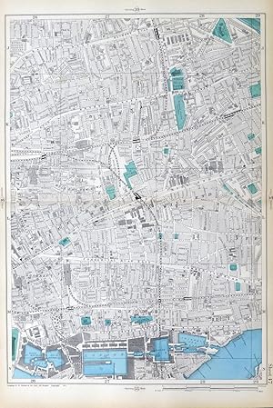
LONDON, 1900 - BETHNAL GREEN , WHITECHAPEL, MILE END, & LONDON DOCKS. - Original Antique Map from Bacon's London & Suburbs, Large 9" per Mile Scale
Edité par G.W.BACON , 27 THE STRAND, LONDON., 1900
Vendeur : End of The World Maps., Penzance, Royaume-Uni
Évaluation du vendeur 5 sur 5 étoiles

Carte
EUR 88,84
Autre deviseEUR 11,50 expédition depuis Royaume-Uni vers Etats-UnisQuantité disponible : 1 disponible(s)
Ajouter au panierNo Binding. Etat : Very Good. Original Antique Map / Plan of London - 1900 - BETHNAL GREEN , WHITECHAPEL, MILE END, & LONDON DOCKS. DESCRIPTION : Large scale, 9 inches to the mile, street plan / map, with original hand colouring, sourced from the first edition of the New Large Scale Atlas of London & Suburbs, published by G.W. Bacon, London. PRINTED IN : 1885. SIZE : Folio : approx 51 x 33 cm, (20" x 13"), IMAGE SIZE: Approx 45 x 30 cm, (18" x 12") NOTES ON CONDITION: A large Original Map in Very Good condition, suitable for framing. Sheet map with centre fold, normal guide remains to verso else clear. Minor aging /marking consistent with light usage only. PACKAGING AND SHIPMENT: - The map is placed in a clear polypropylene protective sleeve, and shipped in an extra strong postal tube. DECLARATION of AUTHENTICITY - We guarantee the map to be an authentic historic map, published at the date stated above. We do not sell reproductions. We include a photograph of the Atlas the map has been sourced from as evidence of its provenance. A Certificate of Authenticity accompanies the map. Important Notes :- - the listing is for the map as described only , any photo's showing the atlas from where the map came from is for information / provenance purposes only. - any watermarking to the photographs above is not , of course, present on the actual map ! - virtually all antiquarian maps and prints are subject to some normal aging due to use and time which is not obtrusive unless otherwise stated. - most higher quality 19th C atlas's mounted maps on "guides" , traces of this will often remain to the back , with no significant detrimental effect to the map itself.
-
LONDON 1906 - WHITECHAPEL, BETHNAL GREEN, MILE END, Original large 9" scale Antique Map
Edité par G.W. Bacon., 1906
Vendeur : End of The World Maps., Penzance, Royaume-Uni
Évaluation du vendeur 5 sur 5 étoiles
Carte
EUR 88,84
Autre deviseEUR 11,50 expédition depuis Royaume-Uni vers Etats-UnisQuantité disponible : 1 disponible(s)
Ajouter au panierNo Binding. Etat : Very Good. Original Antique Map / Plan of London - WHITECHAPEL, BETHNAL GREEN, MILE END. DESCRIPTION : Large scale, 9 inches to the mile, street plan / map, with original hand colouring, sourced from an early edition of the New Large Scale Atlas of London & Suburbs, published by G.W. Bacon, London. PRINTED IN : 1906. SIZE : Folio : approx 51 x 33 cm, (20" x 13"), IMAGE SIZE: Approx 45 x 30 cm, (18" x 12") NOTES ON CONDITION: A large Original Map in Very Good condition, suitable for framing. Sheet map with centre fold, normal guide remains to verso else clear. Minor aging /marking consistent with light usage only. PACKAGING AND SHIPMENT: - The map is placed in a clear polypropylene protective sleeve, and shipped in an extra strong postal tube. DECLARATION of AUTHENTICITY - We guarantee the map to be an authentic historic map, published at the date stated above. We do not sell reproductions. We include a photograph of the Atlas the map has been sourced from as evidence of its provenance. A Certificate of Authenticity accompanies the map. Important Notes :- - the listing is for the map as described only , any photo's showing the atlas from where the map came from is for information / provenance purposes only. - any watermarking to the photographs above is not , of course, present on the actual map ! - virtually all antiquarian maps and prints are subject to some normal aging due to use and time which is not obtrusive unless otherwise stated. - most higher quality 19th C atlas's mounted maps on "guides" , traces of this will often remain to the back , with no significant detrimental effect to the map itself.
-
LONDON - BETHNAL GREEN, WHITECHAPEL, MILE END, SHADWELL & THE LONDON DOCKS - Original Antique Map from Bacon's London & Suburbs, Large 9" per Mile Scale.
Edité par G.W. Bacon, 1909
Vendeur : End of The World Maps., Penzance, Royaume-Uni
Évaluation du vendeur 5 sur 5 étoiles
Carte
EUR 177,69
Autre deviseEUR 11,50 expédition depuis Royaume-Uni vers Etats-UnisQuantité disponible : 1 disponible(s)
Ajouter au panierNo Binding. Etat : Very Good. Original Antique Map / Plan of London - BETHNAL GREEN, WHITECHAPEL, MILE END, SHADWELL & THE LONDON DOCKS. DESCRIPTION : Large scale, 9 inches to the mile, street plan / map, sourced from the New Large Scale Atlas of London & Suburbs, published by G.W. Bacon, London. PRINTED IN : 1909. SIZE : Folio : approx 51 x 33 cm, (20" x 13"), IMAGE SIZE: Approx 45 x 30 cm, (18" x 12") NOTES ON CONDITION: A large Original Map in Very Good condition, suitable for framing. Sheet map with centre fold, normal guide remains to verso else clear. Minor aging /marking consistent with light usage only. PACKAGING AND SHIPMENT: - The map is placed in a clear polypropylene protective sleeve, and shipped in an extra strong postal tube. DECLARATION of AUTHENTICITY - We guarantee the map to be an authentic historic map, published at the date stated above. We do not sell reproductions. We include a photograph of the Atlas the map has been sourced from as evidence of its provenance. A Certificate of Authenticity accompanies the map. Important Notes :- - the listing is for the map as described only , any photo's showing the atlas from where the map came from is for information / provenance purposes only. - any watermarking to the photographs above is not , of course, present on the actual map ! - virtually all antiquarian maps and prints are subject to some normal aging due to use and time which is not obtrusive unless otherwise stated. - most higher quality 19th C atlas's mounted maps on "guides" , traces of this will often remain to the back , with no significant detrimental effect to the map itself.