Montant total (1 article articles) :
Destination de la commande :

map british isles showing cities de walker (2 résultats)
Commentaires
Passer aux résultats principaux de la recherche
Filtres de recherche
Type d'article
- Tous les types de produits
- Livres (Aucun autre résultat ne correspond ŕ ces critčres)
- Magazines & Périodiques (Aucun autre résultat ne correspond ŕ ces critčres)
- Bandes dessinées (Aucun autre résultat ne correspond ŕ ces critčres)
- Partitions de musique (Aucun autre résultat ne correspond ŕ ces critčres)
- Art, Affiches et Gravures (Aucun autre résultat ne correspond ŕ ces critčres)
- Photographies (Aucun autre résultat ne correspond ŕ ces critčres)
- Cartes (2)
- Manuscrits & Papiers anciens (Aucun autre résultat ne correspond ŕ ces critčres)
Etat En savoir plus
- Neuf (Aucun autre résultat ne correspond ŕ ces critčres)
- Comme neuf, Trčs bon ou Bon (Aucun autre résultat ne correspond ŕ ces critčres)
- Assez bon ou satisfaisant (1)
- Moyen ou mauvais (Aucun autre résultat ne correspond ŕ ces critčres)
- Conformément ŕ la description (1)
Reliure
- Toutes
- Couverture rigide (Aucun autre résultat ne correspond ŕ ces critčres)
- Couverture souple (Aucun autre résultat ne correspond ŕ ces critčres)
Particularités
- Ed. originale (Aucun autre résultat ne correspond ŕ ces critčres)
- Signé (Aucun autre résultat ne correspond ŕ ces critčres)
- Jaquette (Aucun autre résultat ne correspond ŕ ces critčres)
- Avec images (2)
- Sans impressions ŕ la demande (2)
Langue (1)
Prix
- Tous les prix
- Moins de EUR 20 (Aucun autre résultat ne correspond ŕ ces critčres)
- EUR 20 ŕ EUR 45 (Aucun autre résultat ne correspond ŕ ces critčres)
- Plus de EUR 45
Livraison gratuite
- Livraison gratuite ŕ destination de France (Aucun autre résultat ne correspond ŕ ces critčres)
Pays
Evaluation du vendeur
-
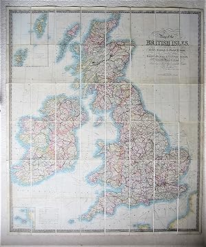
Map of the British Isles, showing Cities, Borough & Market Towns,
Edité par Stanford, London, 1840
Vendeur : Angelika C. J. Friebe Ltd. - MapWoman, Dorking, Royaume-Uni
Membre d'association : ABA ILAB
Évaluation du vendeur 5 sur 5 étoiles

Carte
EUR 590,37
Autre deviseEUR 22,93 expédition depuis Royaume-Uni vers FranceQuantité disponible : 1 disponible(s)
Ajouter au panierNo Binding. Etat : Very Good. original hand coloured map; overall 105 x 110 cm, folds down to 21 x 14 cm, on 40 linen backed segments. some wear and tear; some dusting/ soiling; one 5 cm long split in linen in left part of the map; o/w vg cond. A very large folding map of Great Britain with insets of the Channel, Shetland and Orkney Islands. With two yellow paper boards on the outside; no slipcase.
-
Map of the British Isles, Showing the Cities, Borough & Market Towns, Navigable Rivers & Canals with the Soundings & Sand Banks round the Coast.
Date d'édition : 1840
Vendeur : Altea Antique Maps, London, Royaume-Uni
Membre d'association : ABA ILAB PBFA
Évaluation du vendeur 5 sur 5 étoiles
Carte
EUR 885,56
Autre deviseEUR 28,66 expédition depuis Royaume-Uni vers FranceQuantité disponible : 1 disponible(s)
Ajouter au panierDarlington: W.C. Hobson & London: J. & C. Walker, c.1840. Original colour. Dissected and laid on linen in two sections, as issued, total 1285 x 1000mm, folded into Cruchley slipcase with title label. Cruchley label pasted over original publication inscription. A little discolouration in places. A large map of the British Isles, with two insets: the Orkneys & Shetlands, and the Channel Islands. The colour delineates the counties, with red lines for the railways. This example was sold at G.F. Cruchley's premises in Fleet Street.