
Montant total (1 article articles) :
Destination de la commande :

map europe showing political divisions (20 rťsultats)
Commentaires
Passer aux rťsultats principaux de la recherche
Filtres de recherche
Type d'article
- Tous les types de produits
- Livres (15)
- Magazines & Pťriodiques (Aucun autre rťsultat ne correspond ŗ ces critŤres)
- Bandes dessinťes (Aucun autre rťsultat ne correspond ŗ ces critŤres)
- Partitions de musique (Aucun autre rťsultat ne correspond ŗ ces critŤres)
- Art, Affiches et Gravures (Aucun autre rťsultat ne correspond ŗ ces critŤres)
- Photographies (Aucun autre rťsultat ne correspond ŗ ces critŤres)
- Cartes (5)
- Manuscrits & Papiers anciens (Aucun autre rťsultat ne correspond ŗ ces critŤres)
Etat En savoir plus
- Neuf (Aucun autre rťsultat ne correspond ŗ ces critŤres)
- Comme neuf, TrŤs bon ou Bon (Aucun autre rťsultat ne correspond ŗ ces critŤres)
- Assez bon ou satisfaisant (2)
- Moyen ou mauvais (Aucun autre rťsultat ne correspond ŗ ces critŤres)
- Conformťment ŗ la description (18)
Reliure
- Toutes
- Couverture rigide (Aucun autre rťsultat ne correspond ŗ ces critŤres)
- Couverture souple (Aucun autre rťsultat ne correspond ŗ ces critŤres)
Particularitťs
- Ed. originale (Aucun autre rťsultat ne correspond ŗ ces critŤres)
- Signť (Aucun autre rťsultat ne correspond ŗ ces critŤres)
- Jaquette (Aucun autre rťsultat ne correspond ŗ ces critŤres)
- Avec images (20)
- Sans impressions ŗ la demande (20)
Langue (1)
Livraison gratuite
Pays
Evaluation du vendeur
-
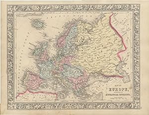
1894 Original Handcolor Map: EUROPE SHOWING ITS POLITICAL DIVISIONS
Editť par Chicago : John E. Potter & Company, 1894
Vendeur : CorgiPack, Fulton, NY, Etats-Unis
…valuation du vendeur 4 sur 5 ťtoiles

Carte
EUR 14,89
Autre deviseGratuit expťdition vers Etats-UnisQuantitť disponible : 1 disponible(s)
Ajouter au panierMap. Etat : Very Good. Original hand-colored leaf from John E. Potter and Company's, "The New Family Atlas." Please refer to photo for condition. PLEASE NOTE: If two images are shown they represent the obverse and reverse of the same leaf--not two separate leaves. Overall dimensions approx. 13" x 15.25". This item will be shipped flat.
-
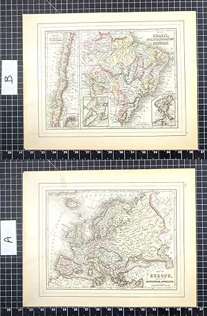
Map of Brazil, Bolivia, Paraguay, and Uruguay (with) Map of Chili [with inset] Harbor of Bahia [with inset] Harbor of Rio Janeiro [with inset] Island of Juan Fernandez [verso with] Map of Europe, Showing Its Gt. Political Divisions
Editť par W.M. Bradley, Philadelphia, 1886
Vendeur : Kaaterskill Books, ABAA/ILAB, East Jewett, NY, Etats-Unis
Membre d'association : ABAA ILAB IOBA
…valuation du vendeur 5 sur 5 ťtoiles

EUR 21,96
Autre deviseEUR 5,97 expťdition vers Etats-UnisQuantitť disponible : 1 disponible(s)
Ajouter au panierHand colored map. Plate 105: Map of Brazil, Bolivia, Paraguay, and Uruguay with two insets of the Harbor of Bahia and the Harbor of Rio de Janeiro [with] Map of Chili, with inset of the Island of Juan Fernandez. Copyright 1886 by Wm. M. Bradley & Bro. 12 x 9.25 inches. [On verso] Plate 106: Map of Europe, Showing Its Gt. Political Divisions. Constructed & Engraved by W. Williams, Philadelphia. Copyright by S. Augustus Mitchell 1884. 13.75 x 11 inches. From: Mitchell's New General Atlas, Containing Maps Of The Various Countries Of The World, Plans Of Cities, Etc., Embraced In Ninety-Three Quarto Maps, Forming A Series Of One Hundred and Forty-seven Maps and Plans, Together With Valuable Statistical Tables. Also, A List Of Post-Offices Of The United States And Territories, And Also Census Of 1880 For States, Territories And Counties, Also Of Cities Of Over 10,000 Inhabitants. Philadelphia: Published By Wm. M. Bradley & Bro., No. 1026 Arch Street. 1886. Very good, faint soiling and browning, few closed edge tears.
-
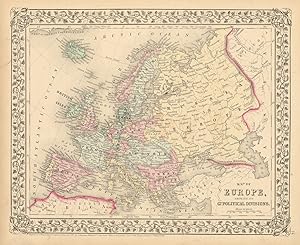
Map of Europe, Showing Its Gt. Political Divisions
Editť par S. Augustus Mitchell, Jr., New York, 1860
Vendeur : Main Street Fine Books & Mss, ABAA, Galena, IL, Etats-Unis
Membre d'association : ABAA ILAB MWABA
…valuation du vendeur 5 sur 5 ťtoiles
Carte
EUR 57,10
Autre deviseEUR 5,12 expťdition vers Etats-UnisQuantitť disponible : 1 disponible(s)
Ajouter au panierFolio (15ľ" X 12ľ", image area 13ľ" X 10Ĺ"). Hand colored. Very good. Light age toning and faint soiling. Delicately colored continental map, from the 1864 edition of "Mitchell's New General Atlas, Containing Maps of the Various Countries of the World, Plans of Cities, Etc." A nice example, with strong floral border.
-

Map of Europe, Showing Its Gt. Political Divisions
Editť par S. Augustus Mitchell, Jr., New York, 1860
Vendeur : Main Street Fine Books & Mss, ABAA, Galena, IL, Etats-Unis
Membre d'association : ABAA ILAB MWABA
…valuation du vendeur 5 sur 5 ťtoiles
Carte
EUR 65,88
Autre deviseEUR 5,12 expťdition vers Etats-UnisQuantitť disponible : 1 disponible(s)
Ajouter au panierFolio (15ľ" X 12ľ", image area 13ľ" X 10Ĺ"). Hand colored. Very good. Mild age toning. A bright and clean continental map, from the 1864 edition of "Mitchell's New General Atlas, Containing Maps of the Various Countries of the World, Plans of Cities, Etc." A superb example, nicely colored and with fine decorative border.
-

map of Europe, Showing its Gt. Political Divisions.
Date d'ťdition : 1885
Vendeur : Art Source International Inc., Boulder, CO, Etats-Unis
…valuation du vendeur 2 sur 5 ťtoiles

EUR 43,92
Autre deviseEUR 13,65 expťdition vers Etats-UnisQuantitť disponible : 3 disponible(s)
Ajouter au panierThis map was made by S. Augustus Mitchell for "Mitchells New General Atlas," published by WM. M. Bradley & Co, 1885. This well-maintained example features Mitchell's characteristic pastel coloring and abundant geographical detail. The map shows the nations of Europe in color and identifies cities, rivers, bodies of water, etc. This map measures 14 inches by 11 inches.
-

Map of Europe, Showing its Political Divisions
Date d'ťdition : 1884
Vendeur : Art Source International Inc., Boulder, CO, Etats-Unis
…valuation du vendeur 2 sur 5 ťtoiles
EUR 43,92
Autre deviseEUR 13,65 expťdition vers Etats-UnisQuantitť disponible : 3 disponible(s)
Ajouter au panierThis map was made by S. Augustus Mitchell for "Mitchells New General Atlas" published in 1884, by WM. M. Bradley & Co. The well maintained maps in this atlas feature Mitchell's characteristic pastel coloring and abundant geographical features. Details include the names of countries, regions, cities, towns, transportation routes, rivers, lakes, and mountain ranges. Regions are distinguished by color. These 1884 maps offer a fascinating perspective of areas that have since undergone significant growth and change, in addition to their value as great examples of Mitchell's work. This map measures 13.25 inches by 10.5 inches.
-

Map of Europe Showing its Political Divisions
Date d'ťdition : 1875
Vendeur : Art Source International Inc., Boulder, CO, Etats-Unis
…valuation du vendeur 2 sur 5 ťtoiles
EUR 43,92
Autre deviseEUR 13,65 expťdition vers Etats-UnisQuantitť disponible : 3 disponible(s)
Ajouter au panierThis map was produced by S. Augustus Mitchell in 1875 for his New General Atlas. This map shows Mitchells traditional grape vine border, characteristic pastel coloring and abundant details of geographical features. Counties are distinguished by different colors. Wagon trails and major routes of transport are also shown. These 1875 maps offer a fascinating perspective of areas that have since undergone significant growth and change, in addition to their value as great examples of Mitchell's work. This map measures 13 inches by 10.5 inches.
-

Map of Europe Showing its G. Political Divisions
Date d'ťdition : 1878
Vendeur : Art Source International Inc., Boulder, CO, Etats-Unis
…valuation du vendeur 2 sur 5 ťtoiles
EUR 48,31
Autre deviseEUR 13,65 expťdition vers Etats-UnisQuantitť disponible : 2 disponible(s)
Ajouter au panierThis map was produced by Augustus Mitchell in 1878 for his New General Atlas. Highlights of this map are Mitchells traditional grapevine border, characteristic pastel coloring and abundant details of geographical features. The political divisions of Europe is illustrated on this map. Countries are distinguished by color. This 1878 map offers a fascinating perspective of areas that have since undergone significant growth and change, in addition to the value as great examples of Mitchell's classic mapmaking style. This map measures 13.5 inches by 10.5 inches.
-

Map of Europe showing its Political Divisions
Date d'ťdition : 1866
Vendeur : Art Source International Inc., Boulder, CO, Etats-Unis
…valuation du vendeur 2 sur 5 ťtoiles
EUR 48,31
Autre deviseEUR 13,65 expťdition vers Etats-UnisQuantitť disponible : 3 disponible(s)
Ajouter au panierThe Mitchell company was one of the first to try out the new technique of engraving on steel plates experimenting with steel almost 20 years before the rest of the publishing industry. He was printing with steel in the early 1830s; the general switch to steel was approximately 1850. During the early years of the company, Mitchell published mainly maps and travel guides. In 1860, Mitchell started producing "Mitchell's New General Atlas",and Mitchell Sr. retired and turned the business over to his sonof the same name. The New General Atlas was published until1893. Today Mitchell maps are sought after for their fine engraving, bright coloring, and attention to detail. They aresome of the finest maps produced during this time period. This map produced in 1866, has Mitchell's unique floral border, and beautiful hand coloring. This map details Europe. Countries, cities, towns, lakes, rivers, mountains, and transportation routes are noted. Each map was printed on thick paper with vibrant hand color. This map measures 13.25 inches by 10.75 inches.
-

Map of Europe, Showing its Government Political Divisions
Date d'ťdition : 1868
Vendeur : Art Source International Inc., Boulder, CO, Etats-Unis
…valuation du vendeur 2 sur 5 ťtoiles
EUR 48,31
Autre deviseEUR 13,65 expťdition vers Etats-UnisQuantitť disponible : 3 disponible(s)
Ajouter au panierThis hand colored map was made for "Mitchells New General Atlas" published by S. Augustus Mitchell, Jr. in 1868. Europe is illustrated on this map. Countries are distinguished by color. Other details include the names of countries, and important cities, rivers, lakes, mountains, and railroads. The maps in this atlas have beautiful color- more muted than typical. This map measures 13.5 inches by 10.5 inches.
-

Map of Europe, Showing its Gt. Political Divisions
Date d'ťdition : 1879
Vendeur : Art Source International Inc., Boulder, CO, Etats-Unis
…valuation du vendeur 2 sur 5 ťtoiles
EUR 52,70
Autre deviseEUR 13,65 expťdition vers Etats-UnisQuantitť disponible : 3 disponible(s)
Ajouter au panierThis map of Europe was produced by Augustus Mitchell in 1879 for his New General Atlas. Highlights of this map are Mitchells traditional grapevine border, characteristic pastel coloring and abundant details of geographical features. This 1879 map offers a fascinating perspective of areas that have since undergone significant growth and change, in addition to the value as great examples of Mitchell's classic map-making style. This map measures 13.5 inches by 11 inches.
-

Map of Europe, Showing its Gt. Political Divisions
Date d'ťdition : 1863
Vendeur : Art Source International Inc., Boulder, CO, Etats-Unis
…valuation du vendeur 2 sur 5 ťtoiles
EUR 52,70
Autre deviseEUR 13,65 expťdition vers Etats-UnisQuantitť disponible : 2 disponible(s)
Ajouter au panierThe Mitchell company was one of the first to try out the new technique of engraving on steel plates, experimenting with steel almost 20 years before the rest of the publishing industry. He was printing with steel in the early 1830s; the general switch to steel engraving was approximately 1850. During the early years of the company, Mitchell published mainly maps and travel guides. In 1860, Mitchell started producing "Mitchell's New General Atlas". Mitchell Sr. retired and turned the business over to his son of the same name. The New General Atlas was published until 1893. Today Mitchell maps are sought after for their fine engraving, bright coloring, and attention to detail. They are some of the finest maps produced in the 1860's. This map, produced in 1863, shows Mitchell's famous flower border, which is only seen in the early editions of his atlases. This map shows Europe. This map measures 13.25 inches by 10.75 inches.
-

Map of Europe Showing its Government Political Divisions
Date d'ťdition : 1870
Vendeur : Art Source International Inc., Boulder, CO, Etats-Unis
…valuation du vendeur 2 sur 5 ťtoiles
EUR 52,70
Autre deviseEUR 13,65 expťdition vers Etats-UnisQuantitť disponible : 1 disponible(s)
Ajouter au panierS. Augustus Mitchell Jr. made this hand colored map for Mitchells New General Atlas in 1870. Europe is illustrated on this map. Regions are distinguished by bright pastel colors. Deserts, lakes, mountains, rivers, important cities and countries are identified. This map measures 13.5 inches by 10.75 inches.
-

Map of Europe, Showing its Gt. Political Divisions
Date d'ťdition : 1888
Vendeur : Art Source International Inc., Boulder, CO, Etats-Unis
…valuation du vendeur 2 sur 5 ťtoiles
EUR 57,10
Autre deviseEUR 13,65 expťdition vers Etats-UnisQuantitť disponible : 1 disponible(s)
Ajouter au panierThis map of Europe was made by S. Augustus Mitchell for "Mitchells New General Atlas" published in 1888, by WM. M. Bradley & Co. The well maintained maps in this atlas feature Mitchell's characteristic pastel coloring and abundant details of geographical features. Details include the names of countries, cities, towns, transportation routes, mountain ranges, rivers and lakes. These 1888 maps offer a fascinating perspective of areas that have since undergone significant growth and change, in addition to their value as great examples of Mitchell's work. This map measures 13.25 inches by 10.5 inches.
-

Map of Europe, Showing Its Political Divisions'
Date d'ťdition : 1872
Vendeur : Art Source International Inc., Boulder, CO, Etats-Unis
…valuation du vendeur 2 sur 5 ťtoiles
EUR 57,10
Autre deviseEUR 13,65 expťdition vers Etats-UnisQuantitť disponible : 3 disponible(s)
Ajouter au panierS. Augustus Mitchell Jr. made this hand colored map for "Mitchells New General Atlas" in 1872. Europe is illustrated on this map. Regions are distinguished by bright pastel colors. Deserts, lakes, mountains, rivers, important cities and countries are identified. This map measures 13 inches by 10 inches.
-

Map of Europe, Showing it Gt. Political Divisions.
Date d'ťdition : 1867
Vendeur : Art Source International Inc., Boulder, CO, Etats-Unis
…valuation du vendeur 2 sur 5 ťtoiles
EUR 57,10
Autre deviseEUR 13,65 expťdition vers Etats-UnisQuantitť disponible : 3 disponible(s)
Ajouter au panierThe Mitchell company was one of the first to try out the newtechnique of engraving on steel plates, experimenting with steelalmost 20 years before the rest of the publishing industry. Hewas printing with steel in the early 1830s; the general switch tosteel was approximately 1850. During the early years of thecompany, Mitchell published mainly maps and travel guides. In1860, Mitchell started producing "Mitchell's New General Atlas",and Mitchell Sr. retired and turned the business over to his sonof the same name. The New General Atlas was published until1893. Today Mitchell maps are sought after for their fineengraving, bright coloring, and attention to detail. They aresome of the finest maps produced in the 1860's. This mapproduced in 1867, has Mitchell's unique floral border, and beautiful hand coloring.This map details Europe, showing it's political divisions. Countries, cities, towns and some topographical features are illustrated. This map measures 13 inches by 10.5 inches.
-
Map of Europe, showing its Gt. Political Divisions
Date d'ťdition : 1869
Vendeur : Antiqua Print Gallery, London, Royaume-Uni
…valuation du vendeur 3 sur 5 ťtoiles

Carte
EUR 59,52
Autre deviseEUR 11,56 expťdition depuis Royaume-Uni vers Etats-UnisQuantitť disponible : 1 disponible(s)
Ajouter au panierEtat : Good. Map of Europe, showing its Political Divisions by S. Augustus Mitchell 1869. Decorative antique atlas map with original hand colour; Samuel Augustus Mitchell Jr. (1869). 29.5 x 36.0cm, 11.5 x 14.25 inches. Condition: Fair: . There is nothing printed on the reverse side, which is plain.
-

Map of Europe Showing its Political Divisions
Date d'ťdition : 1881
Vendeur : Art Source International Inc., Boulder, CO, Etats-Unis
…valuation du vendeur 2 sur 5 ťtoiles
EUR 61,49
Autre deviseEUR 13,65 expťdition vers Etats-UnisQuantitť disponible : 3 disponible(s)
Ajouter au panierThis map came from Mitchells New General Atlas, 1881.This map shows major railroads, water bodies, and towns.Decorative ivy border, and nice colorful detail. Would looknice framed!' This map measures 13.5 inches by 11 inches.
-

Map of Europe, Showing its Gt. Political Divisions
Date d'ťdition : 1864
Vendeur : Art Source International Inc., Boulder, CO, Etats-Unis
…valuation du vendeur 2 sur 5 ťtoiles
EUR 65,88
Autre deviseEUR 13,65 expťdition vers Etats-UnisQuantitť disponible : 2 disponible(s)
Ajouter au panierWith characteristic floral boarders and beautiful, muted pastel coloring, these 1864 maps are fantastic examples of Mitchells work. Regions, important cities, rivers, lakes, and railroads are identified. Europe is illustrated on this map. This map measures 13.25 inches by 10.75 inches.
-

Map of Europe, showing its Gt. Political Divisions.
Date d'ťdition : 1860
Vendeur : Geographicus Rare Antique Maps, Brooklyn, NY, Etats-Unis
Membre d'association : ABAA ESA ILAB
…valuation du vendeur 4 sur 5 ťtoiles
Carte
EUR 98,38
Autre deviseEUR 14,50 expťdition vers Etats-UnisQuantitť disponible : 1 disponible(s)
Ajouter au panierVery good condition. Blank on verso. Size 10.75 x 13 Inches. A beautiful example of S. A. Mitchell Jr.'s 1864 map of Europe. Depicts all of Europe including Iceland. Extends eastwards as far as the Ural Mountains and southward to include parts of North Africa and Turkey. Denotes both political and geographical details. One of the most attractive American atlas maps of this region to appear in the mid-19th century. Features the floral border typical of Mitchell maps from the 1860-65 period. Prepared by W. Williams for inclusion as plate no. 64 in the 1864 issue of Mitchell's New General Atlas . Dated and copyrighted, 'Entered according to Act of Congress in the Year 1860 by S. A. Mitchell Jr. in the Clerk's Office of the District Court of the U.S. for the Eastern District of Pennsylvania. References: Rumsey 0565.032 (1860 edition). Phillips (Atlases) 831. New York Public Library, Map Division, 1510827.
![Image du vendeur pour Map of Brazil, Bolivia, Paraguay, and Uruguay (with) Map of Chili [with inset] Harbor of Bahia [with inset] Harbor of Rio Janeiro [with inset] Island of Juan Fernandez [verso with] Map of Europe, Showing Its Gt. Political Divisions mis en vente par Kaaterskill Books, ABAA/ILAB](https://pictures.abebooks.com/inventory/md/md30661485704.jpg)