Montant total (1 article articles) :
Destination de la commande :

map inhabited part new england (14 rťsultats)
Commentaires
Passer aux rťsultats principaux de la recherche
Filtres de recherche
Type d'article
- Tous les types de produits
- Livres (5)
- Magazines & Pťriodiques (Aucun autre rťsultat ne correspond ŗ ces critŤres)
- Bandes dessinťes (Aucun autre rťsultat ne correspond ŗ ces critŤres)
- Partitions de musique (Aucun autre rťsultat ne correspond ŗ ces critŤres)
- Art, Affiches et Gravures (Aucun autre rťsultat ne correspond ŗ ces critŤres)
- Photographies (Aucun autre rťsultat ne correspond ŗ ces critŤres)
- Cartes (9)
- Manuscrits & Papiers anciens (Aucun autre rťsultat ne correspond ŗ ces critŤres)
Etat En savoir plus
- Neuf (Aucun autre rťsultat ne correspond ŗ ces critŤres)
- Comme neuf, TrŤs bon ou Bon (Aucun autre rťsultat ne correspond ŗ ces critŤres)
- Assez bon ou satisfaisant (2)
- Moyen ou mauvais (Aucun autre rťsultat ne correspond ŗ ces critŤres)
- Conformťment ŗ la description (12)
Reliure
- Toutes
- Couverture rigide (1)
- Couverture souple (Aucun autre rťsultat ne correspond ŗ ces critŤres)
Particularitťs
- Ed. originale (5)
- Signť (Aucun autre rťsultat ne correspond ŗ ces critŤres)
- Jaquette (Aucun autre rťsultat ne correspond ŗ ces critŤres)
- Avec images (10)
- Sans impressions ŗ la demande (14)
Langue (1)
Prix
- Tous les prix
- Moins de EUR 20 (Aucun autre rťsultat ne correspond ŗ ces critŤres)
- EUR 20 ŗ EUR 45 (Aucun autre rťsultat ne correspond ŗ ces critŤres)
- Plus de EUR 45
Livraison gratuite
- Livraison gratuite ŗ destination de France (Aucun autre rťsultat ne correspond ŗ ces critŤres)
Pays
Evaluation du vendeur
-
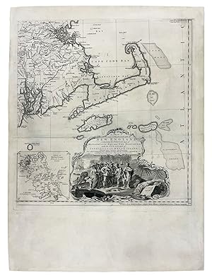
![Image du vendeur pour A Map of the most Inhabited part of New England containing the Provinces of Massachusets [sic.] Bay and New Hampshire, with the Colonies of Conecticut and Rhode Island, Divided into Counties and Townships: The whole composed from Actual Surveys and its Situation adjusted by Astronomical Observations mis en vente par Donald A. Heald Rare Books (ABAA)](https://pictures.abebooks.com/inventory/md/md1303358295.jpg)
A Map of the most Inhabited part of New England containing the Provinces of Massachusets [sic.] Bay and New Hampshire, with the Colonies of Conecticut and Rhode Island, Divided into Counties and Townships: The whole composed from Actual Surveys and its Situation adjusted by Astronomical Observations
Editť par Thomas Jefferys, London, 1774
Vendeur : Donald A. Heald Rare Books (ABAA), New York, NY, Etats-Unis
Membre d'association : ABAA ILAB
…valuation du vendeur 4 sur 5 ťtoiles

Carte Edition originale
EUR 8†784,09
Autre deviseEUR 29,85 expťdition depuis Etats-Unis vers FranceQuantitť disponible : 1 disponible(s)
Ajouter au panierCopper-engraved map, with contemporary outline hand colour, folding, as issued, in 24 sections backed onto linen (overall size: 39 1/2 x 41 1/2 inches). In fine condition with some spotting and toning. Contained within a modern dark red cloth two-fold chemise, all within a dark red morocco-backed cloth slipcase. The largest and most detailed map of New England that had yet been published, and one of the great maps of the east coast of America, by one of the greatest figures in 18th-century cartography: "Mead's contributions to cartography stand out . At a time when the quality and the ethics of map production were at a low ebb in England, he vigorously urged and practiced the highest standards" (Cumming, p.47). This is the grandest, most accurate and detailed map of New England produced during the British colonial period. It depicts the entire region from Long Island Sound up north to line of 44'30 of latitude. While it shows that the coastal areas, and the lower Connecticut Valley were well settled, areas of the interior, especially in New Hampshire and the future Vermont were just developing, with the early boundaries of townships having recently been established by surveyors. Importantly, this map contains two detailed cartographic insets, one of the city of Boston (upper-left), and another of Boston Harbor on the lower-right sheet. The map is also adorned with a very handsome pictorial title cartouche, depicting the arrival of the Pilgrims at Plymouth Rock in 1620. The present map is the third edition and fifth overall state of this work, after the first of 1755 and the second ca. 1763 and ca. 1768, with little alteration from the previous issue beyond the altered imprint. This copy of the 1774 edition is unusual (and more desirable) as it was clearly sold as a separately issued map: the 1774 edition is more usually found as part of Thomas Jefferys monumental The American Atlas of 1775. Jefferys (1719-71) was the leading British mapmaker and publisher of the mid-eighteenth century. He became the geographer to the Prince of Wales in 1746 and then to King George III in 1760. This map's maker, John Green, was an intriguing and larger-than-life figure, who has been called "the genius behind Jefferys". In addition to his extensive cartographic abilities, Green's personal history also stands out from amongst the biographies of other 18th-century British map makers. Green was born Braddock Mead in Ireland around 1688, married in Dublin in 1715 and moved to London in 1717. He was imprisoned in 1728 for trying to defraud an Irish heiress, and assumed his alias after his release from prison. He worked with Ephriam Chambers on his Universal Dictionary before joining the employ of Cave, Astley, and Jefferys. William Cumming remarked that 'had a number of marked characteristics as a cartographer . One was his ability to collect, to analyze the value of, and to use a wide variety of sources; these he acknowledged scrupulously on the maps he designed and even more fully in accompanying remarks. Another outstanding characteristic was his intelligent compilation and careful evaluation of reports on latitudes and longitudes used in the construction of his maps, which he also entered in tables on the face of the maps . Mead's contributions to cartography stand out . At a time when the quality and the ethics of map production were at a low ebb in England, he vigorously urged and practiced the highest standards; in the making of maps and navigational charts he was in advance of his time. For this he deserves due credit.' (Cumming, p.45) Degrees of Latitude, 35; McCorkle, New England in Early Printed Maps 774.4 and cf. 755.19 (first edition/state); Sellers & Van Ee, Maps & Charts of North America & West Indies 1650-1789, 799; Stevens & Tree, "Comparative Cartography" in Tooley, Mapping of America, 33(e); cf. Crone, "John Green. Notes on a neglected Eighteenth Century Geographer and Cartographer," Imago Mundi, VI (1950) p. 89-91; Crone, "Further.
-
![Image du vendeur pour A Map of the most Inhabited part of New England containing the Provinces of Massachusets [sic.] Bay and New Hampshire, with the Colonies of Conecticut and Rhode Island, Divided into Counties and Townships: The whole composed from Actual Surveys and its Situation adjusted by Astronomical Observations mis en vente par Donald A. Heald Rare Books (ABAA)](https://pictures.abebooks.com/inventory/md/md31961378216.jpg)
A Map of the most Inhabited part of New England containing the Provinces of Massachusets [sic.] Bay and New Hampshire, with the Colonies of Conecticut and Rhode Island, Divided into Counties and Townships: The whole composed from Actual Surveys and its Situation adjusted by Astronomical Observations
Editť par Thomas Jefferys, London, 1774
Vendeur : Donald A. Heald Rare Books (ABAA), New York, NY, Etats-Unis
Membre d'association : ABAA ILAB
…valuation du vendeur 4 sur 5 ťtoiles
Carte Edition originale
EUR 7†466,48
Autre deviseEUR 29,85 expťdition depuis Etats-Unis vers FranceQuantitť disponible : 1 disponible(s)
Ajouter au panierCopper-engraved map, with original outline colour, on four sheets, each sheet measuring approximately 20 x 19 1/4 inches, that if joined would form a map measuring approximately 40 x 39 1/2 inches. In good condition overall, except for some small expert repairs to old folds, and margins cut to within the plate mark (in order to join them). The largest and most detailed map of New England that had yet been published, and one of the great maps of the east coast of America, by one of the greatest figures in 18th-century cartography: 'Mead's contributions to cartography stand out . At a time when the quality and the ethics of map production were at a low ebb in England, he vigorously urged and practiced the highest standards' (Cumming, p.47) This is the grandest, most accurate and detailed map of New England produced during the British colonial period. It depicts the entire region from Long Island Sound north to latitude 44'30. While it shows that the coastal areas, and the lower Connecticut Valley were well settled, areas of the interior, especially in New Hampshire and the future Vermont were just developing, with the early boundaries of townships having recently been established by surveyors. Importantly, this map contains two detailed cartographic insets, one of the city of Boston (upper left), and another of Boston Harbor on the lower right sheet. The map is also adorned with a very handsome pictorial title cartouche, depicting the arrival of the Pilgrims at Plymouth Rock in 1620. The present map is the fifth state of this work, and has been significantly updated from the original issue of 1755. The map's publisher, Thomas Jefferys (1719-71) was the leading British mapmaker of the mid-eighteenth century. He became the geographer to the Prince of Wales in 1746 and then to King George III in 1760. He published a remarkable number of maps and charts, and is best known for his posthumous work The American Atlas (1775), of which the present map was a part. This map's maker, John Green, was an intriguing and larger-than-life figure, who has been called "the genius behind Jefferys". In addition to his extensive cartographic abilities, Green's personal history also stands out from amongst the biographies of other 18th-century British map makers. Green was born Braddock Mead in Ireland around 1688, married in Dublin in 1715 and moved to London in 1717. He was imprisoned in 1728 for trying to defraud an Irish heiress, and assumed his alias after his release from prison. He worked with Ephriam Chambers on his Universal Dictionary before joining the employ of Cave, Astley, and Jefferys. William Cumming remarked that 'had a number of marked characteristics as a cartographer . One was his ability to collect, to analyze the value of, and to use a wide variety of sources; these he acknowledged scrupulously on the maps he designed and even more fully in accompanying remarks. Another outstanding characteristic was his intelligent compilation and careful evaluation of reports on latitudes and longitudes used in the construction of his maps, which he also entered in tables on the face of the maps . Mead's contributions to cartography stand out . At a time when the quality and the ethics of map production were at a low ebb in England, he vigorously urged and practiced the highest standards; in the making of maps and navigational charts he was in advance of his time. For this he deserves due credit.' (Cumming, p.45) Degrees of Latitude, 35; McCorkle, New England in Early Printed Maps 774.4 and cf. 755.19 (first edition/state); Sellers & Van Ee, Maps & Charts of North America & West Indies 1650-1789, 799; Stevens & Tree, "Comparative Cartography" in Tooley, Mapping of America, 33(e); cf. Crone, "John Green. Notes on a neglected Eighteenth Century Geographer and Cartographer," Imago Mundi, VI (1950) p. 89-91; Crone, "Further Notes on Braddock Mead, alias John Green" Imago Mundi, VIII (1951) p. 69; Cumming, British Maps of Colonial America, pp.45-47.
-
A Map of the most Inhabited Part of New England containing the Provinces of Massachusets [sic] Bay and New Hampshire, with the Colonies of Conecticut [sic] and Rhode Island, Divided into Counties and Townships; The whole composed from Actual Surveys and its Situation adjusted by Astronomical Observations
Editť par London. Thomas Jefferys, November 29th, 1772, 1772
Vendeur : J. Patrick McGahern Books Inc. (ABAC), Ottawa, ON, Canada
Membre d'association : ABAC ILAB IOBA
…valuation du vendeur 3 sur 5 ťtoiles

EUR 11†741,94
Autre deviseEUR 16,20 expťdition depuis Canada vers FranceQuantitť disponible : 1 disponible(s)
Ajouter au paniercopper-engraved map, four sheets joined, approx. 104.5 x 98cm, [ 41" x 38.5"]., original outline colour; minute loss at few folds; with two detailed insets, one of the city of Boston and the other of Boston Harbour; with the large cartouche depicting the Pilgrims arriving at Plymouth Rock in 1630. A lovely example of this scarce map, some detail wear on the frame, beautifully matted and framed but, rare. Cumming. British Maps of Colonial America, pp45-47. McCorkle. New England in Early Printed Maps, 774-4. Stevens & Tree. Comparative Cartography, 33 (e). This is the fifth state of this work, which was first published in 1755 and updated periodically thereafter; this map was in Jefferys' posthumous (and notoriously scarce) American Atlas of 1775. Thomas Jefferys (1719-71) was a leading British cartographer and publisher; Braddock Mead c.1688-1757, a.k.a., John Green, was an Irishman who was imprisoned in Ireland on grounds of fraud, took on his alias when he was released, and moved to London. He became an extremely practiced and professional cartographer, and held his profession to the highest level. This map contains family names of real estate holders, as well as cartographic details of the New England states from the latitude of 44'30 in the north to Long Island Sound in the south, encompassing part of Maine, Rhode Island, what is now Vermont, New Hampshire, Massachusetts, northern Connecticut, and eastern New York from north of Crown Point through Lake George and down the Hudson River. One of the most important of North American maps, this version was published shortly before the Revolution.
-

Bowles' New Pocket Map of the Most Inhabited Part of New England
Editť par London c. 1776, London, 1776
Vendeur : High Ridge Books, Inc. - ABAA, South Deerfield, MA, Etats-Unis
Membre d'association : ABAA ESA ILAB SNEAB
…valuation du vendeur 5 sur 5 ťtoiles

EUR 6†807,67
Autre deviseEUR 29,85 expťdition depuis Etats-Unis vers FranceQuantitť disponible : 1 disponible(s)
Ajouter au panierRevolutionary War-era edition of this one-sheet edition of Jeffreys' map of New England. Very good condition, small stains in margins at left corners, light horizontal crease, very light scattered foxing. Names, but does not give boundaries for, Vermont. A scarce, attractive Revolutionary War map with a plan of Boston at the bottom right with many locations keyed. Stevens & Tree 32(e).
-
Map of the Most Inhabited Part of New England, Containing .
Editť par London, London, 1774
Vendeur : High Ridge Books, Inc. - ABAA, South Deerfield, MA, Etats-Unis
Membre d'association : ABAA ESA ILAB SNEAB
…valuation du vendeur 5 sur 5 ťtoiles
EUR 7†466,48
Autre deviseEUR 29,85 expťdition depuis Etats-Unis vers FranceQuantitť disponible : 1 disponible(s)
Ajouter au panierFramed, backing not determined. 4 sheets joined, top margin of bottom sheets trimmed. Light wear in western Massachusetts near bottom of the top left sheet. Dated November 29, 1774. A good copy of one of the great 18th century maps of New England. Full color in Vermont, outline color throughout. Uniform age-toning throughout. Stevens & Tree 33(d).
-
A Map of the most Inhabited part of New England containing the Provinces of Massachusets [sic.] Bay and New Hampshire, with the Colonies of Conecticut and Rhode Island, Divided into Counties and Townships: The whole composed from Actual Surveys and its Situation adjusted by Astronomical Observations
Editť par Thomas Jefferys, London, 1774
Vendeur : Donald A. Heald Rare Books (ABAA), New York, NY, Etats-Unis
Membre d'association : ABAA ILAB
…valuation du vendeur 4 sur 5 ťtoiles
Carte Edition originale
EUR 7†466,48
Autre deviseEUR 29,85 expťdition depuis Etats-Unis vers FranceQuantitť disponible : 1 disponible(s)
Ajouter au panier2 sheets. Copper-engraved map printed on four sheets, each sheet measuring approximately 20 x 19 1/4 inches, joined here as two sheets. The two sheets if joined together would form a map measuring approximately 40 x 39 1/2 inches. In good condition overall. The largest and most detailed map of New England that had yet been published, and one of the great maps of the east coast of America, by one of the greatest figures in 18th-century cartography: 'Mead's contributions to cartography stand out . At a time when the quality and the ethics of map production were at a low ebb in England, he vigorously urged and practiced the highest standards' (Cumming, p.47) This is the grandest, most accurate and detailed map of New England produced during the British colonial period. It depicts the entire region from Long Island Sound north to latitude 44'30. While it shows that the coastal areas, and the lower Connecticut Valley were well settled, areas of the interior, especially in New Hampshire and the future Vermont were just developing, with the early boundaries of townships having recently been established by surveyors. Importantly, this map contains two detailed cartographic insets, one of the city of Boston (upper left), and another of Boston Harbor on the lower right sheet. The map is also adorned with a very handsome pictorial title cartouche, depicting the arrival of the Pilgrims at Plymouth Rock in 1620. The present map is the fifth state of this work, and has been significantly updated from the original issue of 1755. The map's publisher, Thomas Jefferys (1719-71) was the leading British mapmaker of the mid-eighteenth century. He became the geographer to the Prince of Wales in 1746 and then to King George III in 1760. He published a remarkable number of maps and charts, and is best known for his posthumous work The American Atlas (1775), of which the present map was a part. This map's maker, John Green, was an intriguing and larger-than-life figure, who has been called "the genius behind Jefferys". In addition to his extensive cartographic abilities, Green's personal history also stands out from amongst the biographies of other 18th-century British map makers. Green was born Braddock Mead in Ireland around 1688, married in Dublin in 1715 and moved to London in 1717. He was imprisoned in 1728 for trying to defraud an Irish heiress, and assumed his alias after his release from prison. He worked with Ephriam Chambers on his Universal Dictionary before joining the employ of Cave, Astley, and Jefferys. William Cumming remarked that 'had a number of marked characteristics as a cartographer . One was his ability to collect, to analyze the value of, and to use a wide variety of sources; these he acknowledged scrupulously on the maps he designed and even more fully in accompanying remarks. Another outstanding characteristic was his intelligent compilation and careful evaluation of reports on latitudes and longitudes used in the construction of his maps, which he also entered in tables on the face of the maps . Mead's contributions to cartography stand out . At a time when the quality and the ethics of map production were at a low ebb in England, he vigorously urged and practiced the highest standards; in the making of maps and navigational charts he was in advance of his time. For this he deserves due credit.' (Cumming, p.45) Degrees of Latitude, 35; McCorkle, New England in Early Printed Maps 774.4 and cf. 755.19 (first edition/state); Sellers & Van Ee, Maps & Charts of North America & West Indies 1650-1789, 799; Stevens & Tree, "Comparative Cartography" in Tooley, Mapping of America, 33(e); cf. Crone, "John Green. Notes on a neglected Eighteenth Century Geographer and Cartographer," Imago Mundi, VI (1950) p. 89-91; Crone, "Further Notes on Braddock Mead, alias John Green" Imago Mundi, VIII (1951) p. 69; Cumming, British Maps of Colonial America, pp.45-47.
-

Map of the Most Inhabited Part of New England.
Editť par London: Sayer & Bennett, June 1775 (1776)., 1776
Vendeur : Arader Galleries - AraderNYC, New York, NY, Etats-Unis
…valuation du vendeur 5 sur 5 ťtoiles
Carte
EUR 6†588,07
Autre deviseEUR 29,85 expťdition depuis Etats-Unis vers FranceQuantitť disponible : 1 disponible(s)
Ajouter au panierNo Binding. Etat : Good. AN EXCEPTIONALLY FINE ENGRAVED MAP OF NEW ENGLAND WITH SUPERB ORIGINAL COLOUR, the title within an elaborate asymmetrical rococo cartouche with a fine vignette of the Pilgrims and Native Americans at Plymouth Rock lower right, an inset plans of the Town of Boston upper left, and Boston Harbour lower right (old folds, some offsetting). First published in 1755, this edition is from Thomas Jeffery's celebrated "American Atlas: or, a geographical description of the whole continent of America", R. Sayer and Bennett, 1775, which updated the map and re-issued it at a time of intense interest in Revolutionary Boston. Mead's map of New England was the most detailed and informative pre-Revolutionary map of New England, as well as the first large-scale representation of the region. Green's map remained the primary authority for the region until the 19th century, and ranks in importance with Mouzon's North and South Carolina, Fry and Jefferson's Virginia and Maryland, and Scull's Pennsylvania." This issue includes insets of Boston Harbor and the Town of Boston, rather than Fort Frederick on Lake Champlain. Frequently working under the alias of 'John Green', Braddock Mead was Thomas Jefferys' brilliant but eccentric cartographer and draughtsman. Mead carefully collected, analyzed, and synthesized information from disparate sources, which he acknowledged on his maps. This map of New England demonstrates an intelligent compilation and careful evaluation of reports on latitudes and longitudes. At a time when the quality and ethics of map production were at low ebb in England, Mead vigorously urged and practiced high standards; in the making of maps and nautical charts he was in advance of his time. Like Mouzon's Carolinas, Mead's New England was one of the foremost maps included in Thomas Jefferys' "American Atlas". Jefferys was geographer to the Prince of Wales, later King George III, and the leading map supplier of his day. His "American Atlas" is the most important 18th-century atlas for America, described by Walter Ristow as a "geographical description of the whole continent of America, as portrayed in the best available maps in the latter half of the eighteenth century. as a major cartographic reference work it was, very likely, consulted by American, English, and French civilian administrators and military officers during the Revolution." Jefferys published some of "the most important eighteenth-century maps of the Americas, a series given cohesion and impetus by the preliminary hostilities and eventual outbreak of the Seven Years' War. Among many individual works of note were Joshua Fry's and Peter Jefferson's 1751 survey of Virginia, engraved and published by Jefferys in 1753, and Joseph Blanchard's and Samuel Langdon's New Hampshire (1761), the first published map of the state. The culmination of this concentration of work was the atlas published in association with Robert Sayer as A General Topography of North America in 1768. Posthumous collections were published by Sayer in 1775 as The American Atlas, The North-American Pilot, including important charts by James Cook, and The West-India Atlas, for which a collection of working drafts survives in the British Library" (DNB).
-
A Map of the most Inhabited part of New England containing the Provinces of Massachusets Bay and New Hampshire, with the Colonies of Conecticut and Rhode Island, Divided into Counties and Townships: The whole composed from Actual Surveys and its Situation adjusted by Astronomical Observations
Editť par Chez Le Rouge rue des grands Augustins, Paris, 1777
Vendeur : Donald A. Heald Rare Books (ABAA), New York, NY, Etats-Unis
Membre d'association : ABAA ILAB
…valuation du vendeur 4 sur 5 ťtoiles
Carte
EUR 6†588,07
Autre deviseEUR 29,85 expťdition depuis Etats-Unis vers FranceQuantitť disponible : 1 disponible(s)
Ajouter au panierCopper-engraved map, on four joined sheets, with original outline colour, in excellent condition. A very fine copy of this highly important and large scale map of New England, the finest map of the region available to military commanders during the Revolutionary War. This is the grandest, most accurate and detailed map of New England produced during the British colonial period. It depicts the entire region from Long Island Sound up north to the line of 44'30 of latitude. While it shows that the coastal areas and the lower Connecticutt Valley were well settled, areas of the interior, especially in New Hampshire and the future Vermont were just developing, with the early boundaries of townships having recently been established by surveyors. Importantly, this map contains two detailed cartographic insets, one of the city of Boston (upper-left), and another of Boston Harbor on the lower-right sheet. The map is also adorned with a very handsome pictorial title cartouche, depicting the arrival of the Pilgrims at Plymouth Rock in 1620. The present map is the edition produced by Georges-Louis Le Rouge, then the royal Geographer to Louis XVI, and was significantly updated from the original issue of 1755. Copies of this issue would most certainly have been consulted by French commanders such as the Comtes D'Estaing and Rochambeau who both led forces in New England following France's entry into the Revolutionary War in support of the American cause in 1778. This map's maker, John Green, was an intriguing and larger-than-life figure, who has been called "the genius behind Jefferys". In addition to his extensive cartographic abilities, Green's personal history also stands out from amongst the biographies of other 18th-century British map makers. Green was born Braddock Mead in Ireland around 1688, married in Dublin in 1715 and moved to London in 1717. He was imprisoned in 1728 for trying to defraud an Irish heiress, and assumed his alias after his release from prison. He worked with Ephriam Chambers on his Universal Dictionary before joining the employ of Cave, Astley, and Jefferys. William Cumming remarked that Mead/Green 'had a number of marked characteristics as a cartographer . One was his ability to collect, to analyze the value of, and to use a wide variety of sources; these he acknowledged scrupulously on the maps he designed and even more fully in accompanying remarks. Another outstanding characteristic was his intelligent compilation and careful evaluation of reports on latitudes and longitudes used in the construction of his maps, which he also entered in tables on the face of the maps . Mead's contributions to cartography stand out . At a time when the quality and the ethics of map production were at a low ebb in England, he vigorously urged and practiced the highest standards; in the making of maps and navigational charts he was in advance of his time. For this he deserves due credit.' (Cumming, p.45). McCorkle, New England in Early Printed Maps, 755.19; Sellers & Van Ee, Maps & Charts of North America & West Indies, 802; cf. Crone, "John Green. Notes on a neglected Eighteenth Century Geographer and Cartographer," Imago Mundi, VI (1950) p. 89-91; Crone, "Further Notes on Braddock Mead, alias John Green" Imago Mundi, VIII (1951) p. 69; Cumming, British Maps of Colonial America, pp.45-47.
-

A Map of the most Inhabited Part of New England Containing the Provinces of Massachusetts Bay, New Hampshire and the Colonies of Connecticut and Rhode Island.
Editť par c. 1777, London, 1777
Vendeur : Alexandre Antique Prints, Maps & Books, Toronto, ON, Canada
Membre d'association : ABAC ILAB
…valuation du vendeur 5 sur 5 ťtoiles
Carte
EUR 1†932,50
Autre deviseEUR 7,25 expťdition depuis Canada vers FranceQuantitť disponible : 1 disponible(s)
Ajouter au panierEtat : Very Good. This is the lower left sheet of the four sheet map. The map depicts all of Long Island, the Hudson River through the Colony of Connecticut, and to the western part of Rhode Island. It extends to include the southwestern part of Massachusetts.This map provides an excellent reference to early place names, it identifies numerous land grants, towns, roads, trails, portages, forts, farms and topography."The second edition of Le Rouge's copy of Jeffery's map of New England. Place names in English, legends in French" (McCorkle), Size : 530x500 (mm), 20.875x19.625 (Inches), Hand Colored in Outline, 0.
-
A Map of the Most Inhabited part of New England containing the Provinces of Massachusetts Bay and New Hampshire with the Colonies of Connecticut and Rhode Island, Divided into Counties and Townships.
Editť par Probst c. 1777, Augsburg, 1777
Vendeur : Alexandre Antique Prints, Maps & Books, Toronto, ON, Canada
Membre d'association : ABAC ILAB
…valuation du vendeur 5 sur 5 ťtoiles
Carte
EUR 2†196,02
Autre deviseEUR 7,25 expťdition depuis Canada vers FranceQuantitť disponible : 1 disponible(s)
Ajouter au panierEtat : Excellent. Sheet 1 of this celebrated 4 sheet map, Size : 540x530 (mm), 21.25x20.875 (Inches), Original Hand Coloring, 0.
-
A Map of the most Inhabited part of New England containing the Provinces of Massachusets Bay and New Hampshire, with the Colonies of Conecticut and Rhode Island, Divided into Counties and Townships: The whole composed from Actual Surveys and its Situation adjusted by Astronomical Observations
Editť par Thomas Jefferys, London, 1764
Vendeur : Donald A. Heald Rare Books (ABAA), New York, NY, Etats-Unis
Membre d'association : ABAA ILAB
…valuation du vendeur 4 sur 5 ťtoiles
Carte Edition originale
EUR 8†784,09
Autre deviseEUR 29,85 expťdition depuis Etats-Unis vers FranceQuantitť disponible : 1 disponible(s)
Ajouter au panierCopper-engraved map, on four unjoined and untrimmed sheets as issued. The largest and most detailed map of New England that had yet been published, and one of the great maps of the east coast of America, by one of the greatest figures in 18th-century cartography: 'Mead's contributions to cartography stand out . At a time when the quality and the ethics of map production were at a low ebb in England, he vigorously urged and practiced the highest standards' (Cumming, p.47). This is the grandest, most accurate and detailed map of New England produced during the British colonial period. It depicts the entire region from Long Island Sound up north to line of 44'30 of latitude. While it shows that the coastal areas, and the lower Connecticut Valley were well settled, areas of the interior, especially in New Hampshire and the future Vermont were just developing, with the early boundaries of townships having recently been established by surveyors. Importantly, this map contains two highly-detailed cartographic insets, one of the city of Boston (upper-left), and another of Boston Harbor on the lower-right sheet. The map is also adorned with a very handsome pictorial title cartouche, depicting the arrival of the Pilgrims at Plymouth Rock in 1620. The present map is the first issue of the second edition of this work, and has been significantly updated from the original issue of 1755. The map's publisher, Thomas Jefferys was the leading British mapmaker of the mid-eighteenth century. He became geographer to the Prince of Wales in 1746 and then to King George III in 1760. He published a remarkable number of maps and charts, and is best known for his work The American Atlas (1775) This map's maker, John Green, was an intriguing and larger-than-life figure, who has been called "the genius behind Jefferys." In addition to his extensive cartographic abilities, Green's personal history also stands out from amongst the biographies of other 18th-century British map makers. Green was born Braddock Mead in Ireland around 1688, married in Dublin in 1715 and moved to London in 1717. He was imprisoned in 1728 for trying to defraud an Irish heiress, and assumed his alias after his release from prison. He worked with Ephriam Chambers on his Universal Dictionary before joining the employ of Cave, Astley, and Jefferys. William Cumming remarked that he 'had a number of marked characteristics as a cartographer . One was his ability to collect, to analyze the value of, and to use a wide variety of sources; these he acknowledged scrupulously on the maps he designed and even more fully in accompanying remarks. Another outstanding characteristic was his intelligent compilation and careful evaluation of reports on latitudes and longitudes used in the construction of his maps, which he also entered in tables on the face of the maps . Mead's contributions to cartography stand out . At a time when the quality and the ethics of map production were at a low ebb in England, he vigorously urged and practiced the highest standards; in the making of maps and navigational charts he was in advance of his time. For this he deserves due credit.' (Cumming, p.45) Degrees of Latitude, 35; McCorkle, New England in Early Printed Maps, 755.19 (first edition/state); Sellers & Van Ee, Maps & Charts of North America & West Indies, 799; Stevens & Tree, "Comparative Cartography," 33(c), in Tooley, The Mapping of America. Cf. Crone, "John Green. Notes on a neglected Eighteenth Century Geographer and Cartographer," Imago Mundi, VI (1950) p. 89-91; Crone, "Further Notes on Braddock Mead, alias John Green" Imago Mundi, VIII (1951) p. 69; Cumming, British Maps of Colonial America, pp.45-47.
-
A Map of the most Inhabited part of New England containing the Provinces of Massachusets Bay and New Hampshire, with the Colonies of Connecticut and Rhode Island, Divided into Counties and Townships. The whole composed from Actual Surveys and its Situation adjusted by Astronomical Observations
Editť par Tobias Conrad Lotter, [Augsburg], 1776
Vendeur : Donald A. Heald Rare Books (ABAA), New York, NY, Etats-Unis
Membre d'association : ABAA ILAB
…valuation du vendeur 4 sur 5 ťtoiles
Carte
EUR 6†588,07
Autre deviseEUR 29,85 expťdition depuis Etats-Unis vers FranceQuantitť disponible : 1 disponible(s)
Ajouter au panierHand-coloured engraving by T. C. Lotter, on four sheets. Good condition. Each sheet: 27 1/4 x 22 3/4 inches approx. One of the great maps of New England. This large, intriguing map of New England was originally drawn by a shadowy figure named Braddock Mead, an Irishman and a geographer, who had to change his name to escape prosecution for kidnapping and related charges. He chose the name John Green and continued his geographical and cartographical work with several different publishers, ending up with Thomas Jefferys, the leading map publisher in London at that time. Only one map actually bears the name "J. Green", but there are characteristic traits to Mead/Green's maps that make the attributions fairly certain, and Jefferys states that he worked on "many of my Geographical performances." G. R. Crone brought Green's identity to light in two Imago Mundi articles in the early 1950s. The map was the first large scale printed map of New England. Six different states of the map appeared in London between 1755 and 1794. This edition was engraved by Tobias Conrad Lotter, Matthew Seutter's son-in-law, in Augsburg, in 1776 based on the 4th state of the map. It is an exact copy of the Jefferys' map with the inset maps of Boston and of Boston Harbor and the vignette of the Pilgrims' landing at Plymouth in the cartouche. Interest in events taking place in New England in 1776 was of course intense, and the sharply drawn inset maps of Boston would have been especially appreciated. The map is rich in fascinating information for New Englanders, and it is displayed with great clarity. From a historical viewpoint, Mead's map shows the extent of European dominion in the region after a century and a half of settlement and growth. G. R. Crone, "John Green. Notes on a neglected Eighteenth Century Geographer and Cartographer," Imago Mundi, VI (1950) p. 89-91; Crone, "Further Notes on Braddock Mead, alias John Green." Imago Mundi, VIII (1951) p. 69; Mapping Colonial America. Degrees of Latitude. # 35; Cumming, British Maps of Colonial America, p. 45-47.
-
A map of the most inhabited part of New England, containing provinces of Massachusetts Bay and New Hampshire, with the colonies of Konektikut and Rhode Island divided into counties and townships.
Editť par London, , c.1760., 1760
Vendeur : Alexandre Antique Prints, Maps & Books, Toronto, ON, Canada
Membre d'association : ABAC ILAB
…valuation du vendeur 5 sur 5 ťtoiles
EUR 768,61
Autre deviseEUR 7,25 expťdition depuis Canada vers FranceQuantitť disponible : 1 disponible(s)
Ajouter au panierOnly one of the four sheets of the important New England map by Jefferys with the inset of a plan of the town of Boston. Size: 517mm x 488mm, 20 3/8"x 19 1/4". Hand Colored, Good.
-
A Map of the most Inhabited part of New England containing the Provinces of Massachusets Bay and New Hampshire, with the Colonies of Conecticut and Rhode Island, Divided into Counties and Townships: The whole composed from Actual Surveys and its Situation adjusted by Astronomical Observations.
Vendeur : Antiquariaat A. Kok & Zn. B.V., Amsterdam, Pays-Bas
Membre d'association : ILAB NVVA
…valuation du vendeur 4 sur 5 ťtoiles
Edition originale
EUR 11†000
Autre deviseEUR 15,95 expťdition depuis Pays-Bas vers FranceQuantitť disponible : 1 disponible(s)
Ajouter au panier[London], Thomas Jefferys, 1774. Copper-engraved map [sheet size: 106 x 102 cm] with orig. handcolouring (mainly coloured in outlines), printed on four joined sheets and mounted on 18th century linen. - Folded (worn/dam. along the folds; the folds are strenghtened on verso with strips of paper).Rare separately issued example of Bradock Mead's remarkable large format map of New England & Long Island. A copy of the third edition of 1774, a significantly updated edition of the first edition of 1755. This is the most detailed and accurate map of New England published during the British colonial period. It has a decorative pictorial title cartouche depicting the arrival of the Pilgrim's landing at Plymouth Rock in 1620, and two cartopgraphic insets (a plan of the city of Boston & a plan of the Boston Harbor). This map is normally referred to as being made by Thomas Jefferys, it was actually drawn by his assistant Braddock Mead (alias John Green). Braddock Mead based this map largely on William Douglass' map of 1753. Other sources include a 1737 manuscript survey of Connecticut by Gardner and Kellock, and manuscript drafts by Richard Hazzens and George Mitchell. # McCorkle, New England in Early Printed Maps , 755.19 (first edition); Sellers & Van Ee, Maps & Charts of North America & West Indies, 799.
![Image du vendeur pour A Map of the most Inhabited Part of New England containing the Provinces of Massachusets [sic] Bay and New Hampshire, with the Colonies of Conecticut [sic] and Rhode Island, Divided into Counties and Townships; The whole composed from Actual Surveys and its Situation adjusted by Astronomical Observations mis en vente par J. Patrick McGahern Books Inc. (ABAC)](https://pictures.abebooks.com/inventory/md/md31852694561.jpg)
![Image du vendeur pour A Map of the most Inhabited part of New England containing the Provinces of Massachusets [sic.] Bay and New Hampshire, with the Colonies of Conecticut and Rhode Island, Divided into Counties and Townships: The whole composed from Actual Surveys and its Situation adjusted by Astronomical Observations mis en vente par Donald A. Heald Rare Books (ABAA)](https://pictures.abebooks.com/inventory/md/md31357566352.jpg)