
Montant total (1 article articles) :
Destination de la commande :

map north america showing political (16 résultats)
Commentaires
Passer aux résultats principaux de la recherche
Filtres de recherche
Type d'article
- Tous les types de produits
- Livres (15)
- Magazines & Périodiques (Aucun autre résultat ne correspond ŕ ces critčres)
- Bandes dessinées (Aucun autre résultat ne correspond ŕ ces critčres)
- Partitions de musique (Aucun autre résultat ne correspond ŕ ces critčres)
- Art, Affiches et Gravures (Aucun autre résultat ne correspond ŕ ces critčres)
- Photographies (Aucun autre résultat ne correspond ŕ ces critčres)
- Cartes (1)
- Manuscrits & Papiers anciens (Aucun autre résultat ne correspond ŕ ces critčres)
Etat En savoir plus
- Neuf (Aucun autre résultat ne correspond ŕ ces critčres)
- Comme neuf, Trčs bon ou Bon (Aucun autre résultat ne correspond ŕ ces critčres)
- Assez bon ou satisfaisant (1)
- Moyen ou mauvais (Aucun autre résultat ne correspond ŕ ces critčres)
- Conformément ŕ la description (15)
Reliure
- Toutes
- Couverture rigide (Aucun autre résultat ne correspond ŕ ces critčres)
- Couverture souple (Aucun autre résultat ne correspond ŕ ces critčres)
Particularités
- Ed. originale (Aucun autre résultat ne correspond ŕ ces critčres)
- Signé (Aucun autre résultat ne correspond ŕ ces critčres)
- Jaquette (Aucun autre résultat ne correspond ŕ ces critčres)
- Avec images (16)
- Sans impressions ŕ la demande (16)
Langue (1)
Livraison gratuite
- Livraison gratuite ŕ destination de France (Aucun autre résultat ne correspond ŕ ces critčres)
Pays
Evaluation du vendeur
-
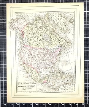
1894 Original Handcolor Map: NORTH AMERICA SHOWING ITS POLITICAL DIVISIONS AND RECENT DISCOVERIES IN THE POLAR REGIONS
Edité par Chicago : John E. Potter & Company, 1894
Vendeur : CorgiPack, Fulton, NY, Etats-Unis
Évaluation du vendeur 4 sur 5 étoiles

Carte
EUR 16,51
Autre deviseEUR 21,10 expédition depuis Etats-Unis vers FranceQuantité disponible : 1 disponible(s)
Ajouter au panierMap. Etat : Very Good. Short neat edge tear to left edge. Original hand-colored leaf from John E. Potter and Company's, "The New Family Atlas." Please refer to photo for condition. PLEASE NOTE: If two images are shown they represent the obverse and reverse of the same leaf--not two separate leaves. Overall dimensions approx. 13" x 15.25". This item will be shipped flat.
-

Map of North America- Showing its Political Divisions and Recent Discoveries in the Polar Regions
Date d'édition : 1887
Vendeur : Art Source International Inc., Boulder, CO, Etats-Unis
Évaluation du vendeur 2 sur 5 étoiles

EUR 65,32
Autre deviseEUR 33,82 expédition depuis Etats-Unis vers FranceQuantité disponible : 3 disponible(s)
Ajouter au panierThis map was made by S. Augustus Mitchell for "Mitchells New General Atlas" published in 1887. The well maintained maps in this atlas feature Mitchell's characteristic pastel coloring and abundant details of geographical features. North America is illustrated on this map. Details include the names of regions, important towns, rivers, deserts, lakes, and mountain ranges. Regions are distinguished by color. These 1887 maps offer a fascinating perspective of areas that have since undergone significant growth and change, in addition to their value as great examples of Mitchell's work. This map has water stains in the margin that do not affect the map. This map measures 11.25 inches by 13 inches.
-

Map of North America Showing its Political Divisions and Recent Discoveries in the Polar Regions
Date d'édition : 1884
Vendeur : Art Source International Inc., Boulder, CO, Etats-Unis
Évaluation du vendeur 2 sur 5 étoiles
EUR 69,68
Autre deviseEUR 33,82 expédition depuis Etats-Unis vers FranceQuantité disponible : 3 disponible(s)
Ajouter au panierThis map was made by S. Augustus Mitchell for "Mitchells New General Atlas" published in 1884, by WM. M. Bradley & Co. The well maintained maps in this atlas feature Mitchell's characteristic pastel coloring and abundant geographical features. Details include the names of countries, regions, cities, towns, transportation routes, rivers, lakes, and mountain ranges. Regions are distinguished by color. These 1884 maps offer a fascinating perspective of areas that have since undergone significant growth and change, in addition to their value as great examples of Mitchell's work. This map measures 10.5 inches by 13.5 inches.
-

Map of North America, Showing its Political Divisions, and Recent Discoveries in Polar Regions'
Date d'édition : 1885
Vendeur : Art Source International Inc., Boulder, CO, Etats-Unis
Évaluation du vendeur 2 sur 5 étoiles
EUR 74,03
Autre deviseEUR 33,82 expédition depuis Etats-Unis vers FranceQuantité disponible : 3 disponible(s)
Ajouter au panierThis map was made by S. Augustus Mitchell for "Mitchells New General Atlas" published in 1885, by WM. M. Bradley & Co. The well maintained maps in this atlas feature Mitchell's characteristic pastel coloring and abundant details of geographical features. North America, with recent discoveries in the Polar Regions are illustrated. Details include the names of countries, regions, states, cities, mountain ranges and Peaks , explorer routes, lakes and rivers. Countries are differentiated by coloring. These 1885 maps offer a fascinating perspective of areas that have since undergone significant growth and change, in addition to their value as great examples of Mitchell's work. This map measures 10 inches by 12 inches.
-

Map of North America Showing its Political Divisions, and Recent Discoveries in the Polar Regions
Date d'édition : 1872
Vendeur : Art Source International Inc., Boulder, CO, Etats-Unis
Évaluation du vendeur 2 sur 5 étoiles
EUR 74,03
Autre deviseEUR 33,82 expédition depuis Etats-Unis vers FranceQuantité disponible : 3 disponible(s)
Ajouter au panierThis exceptional map was published by S. Augustus Mitchell, Jr in 1872. The steel plate engraved map has original hand coloring and has been very well maintained with bright color and crisp lines. Surrounding this map of North America is a ' inch floral border. Countries, states, many cities, rivers and lakes are identified on this beautiful map. This map measures 11 inches by 13.5 inches.
-

Map of North America, Showing its Political Divisions
Date d'édition : 1870
Vendeur : Art Source International Inc., Boulder, CO, Etats-Unis
Évaluation du vendeur 2 sur 5 étoiles
EUR 74,03
Autre deviseEUR 33,82 expédition depuis Etats-Unis vers FranceQuantité disponible : 2 disponible(s)
Ajouter au panierS. Augustus Mitchell Jr. made this hand colored map for Mitchells New General Atlas in 1870. North America is illustrated on this map. Regions are distinguished by bright pastel colors. Deserts, lakes, mountains, rivers, important cities and countries are identified. Recent explorations and discoveries in Antarctica are labeled as well. This map measures 11.5 inches by 13.5 inches.
-

Map of North America showing its Political Divisions and Recent Discoveries in the Polar Regions
Date d'édition : 1888
Vendeur : Art Source International Inc., Boulder, CO, Etats-Unis
Évaluation du vendeur 2 sur 5 étoiles
EUR 74,03
Autre deviseEUR 33,82 expédition depuis Etats-Unis vers FranceQuantité disponible : 2 disponible(s)
Ajouter au panierThis map of North America was made by S. Augustus Mitchell for "Mitchells New General Atlas" published in 1888, by WM. M. Bradley & Co. The well maintained maps in this atlas feature Mitchell's characteristic pastel coloring and abundant details of geographical features. Details include the names of countries, cities, towns, transportation routes, mountain ranges, rivers and lakes. Also included is Captain McClure's discovery of the Northwest Passage. These 1888 maps offer a fascinating perspective of areas that have since undergone significant growth and change, in addition to their value as great examples of Mitchell's work. This map measures 10.75 inches by 14 inches.
-

Map of North America Showing its Political Divisions
Date d'édition : 1868
Vendeur : Art Source International Inc., Boulder, CO, Etats-Unis
Évaluation du vendeur 2 sur 5 étoiles
EUR 78,39
Autre deviseEUR 33,82 expédition depuis Etats-Unis vers FranceQuantité disponible : 3 disponible(s)
Ajouter au panierThis hand colored map was made for "Mitchells New General Atlas" published in 1868 by S. Augustus Mitchell, Jr. North America is illustrated on this map. States and countries are distinguished by color. Other details include the names of countries and important cities, railroads, major roads,and rivers. The pastel coloring in this atlas is very beautiful and more muted than typical. This map measures 11.25 inches by 13.5 inches.
-

Map of North America showing its Political Divisions, and Recent Discoveries in the Polar Regions'
Date d'édition : 1877
Vendeur : Art Source International Inc., Boulder, CO, Etats-Unis
Évaluation du vendeur 2 sur 5 étoiles
EUR 78,39
Autre deviseEUR 33,82 expédition depuis Etats-Unis vers FranceQuantité disponible : 1 disponible(s)
Ajouter au panierThis hand colored map was made in 1877 by S. Augustus Mitchell for "Mitchells New General Atlas". North America is illustrated on this map. Countries are distinguished by color. Other details include the names of states, important cities, rivers, mountains, and lakes. This map measures 10.5 inches by 14 inches.
-

Map of North America Showing its Political Divisions and Recent Discoveries in the Polar Regions
Date d'édition : 1875
Vendeur : Art Source International Inc., Boulder, CO, Etats-Unis
Évaluation du vendeur 2 sur 5 étoiles
EUR 82,74
Autre deviseEUR 33,82 expédition depuis Etats-Unis vers FranceQuantité disponible : 2 disponible(s)
Ajouter au panierThis map was produced by S. Augustus Mitchell in 1875 for his New General Atlas. This map shows Mitchells traditional grape vine border, characteristic pastel coloring and abundant details of geographical features. Counties are distinguished by different colors. Wagon trails and major routes of transport are also shown. These 1875 maps offer a fascinating perspective of areas that have since undergone significant growth and change, in addition to their value as great examples of Mitchell's work. This map measures 11 inches by 13.5 inches.
-

Mitchell's 1865 Map of North America showing its Political Divisions and Recent Discoveries in the Polar Regions
Date d'édition : 1865
Vendeur : Art Source International Inc., Boulder, CO, Etats-Unis
Évaluation du vendeur 2 sur 5 étoiles
EUR 87,10
Autre deviseEUR 33,82 expédition depuis Etats-Unis vers FranceQuantité disponible : 2 disponible(s)
Ajouter au panierIn 1860 S. Augustus Mitchell Jr. took over his father's map publishing business and in that year he started publishing Mitchell's New General Atlas. Editions of the new general were issued annually until 1887. Mitchell Jr. continued publishing this atlas until 1879. The editions from 1880 to 1887 were published by Wm. M. Bradley. This map published in 1865 is a wonderful example of Mitchell's map-making prowess with beautiful original hand-coloring. This map measures 10.5 inches by 13.5 inches.
-

Map of North America Showing its Political Divisions, and Recent Discoveries in the Polar Regions'
Date d'édition : 1867
Vendeur : Art Source International Inc., Boulder, CO, Etats-Unis
Évaluation du vendeur 2 sur 5 étoiles
EUR 87,10
Autre deviseEUR 33,82 expédition depuis Etats-Unis vers FranceQuantité disponible : 3 disponible(s)
Ajouter au panierThe Mitchell company was one of the first to try out the new technique of engraving on steel plates, experimenting with steel almost 20 years before the rest of the publishing industry. He was printing with steel in the early 1830s; the general switch to steel was approximately 1850. During the early years of the company, Mitchell published mainly maps and travel guides. In 1860, Mitchell started producing "Mitchell's New General Atlas", and Mitchell Sr. retired and turned the business over to his son of the same name. The New General Atlas was published until 1893. Today Mitchell maps are sought after for their fine engraving, bright coloring, and attention to detail. They are some of the finest maps produced in the 1860's. This map produced in 1867, has Mitchell's unique floral border, and beautiful hand coloring. This map details North America. Political divisions, cities, states and topographical features are noted. This map measures 10.5 inches by 13.5 inches.
-

Map of North America showing its Political Divisions and recent discoveries in the Polar Regions
Date d'édition : 1866
Vendeur : Art Source International Inc., Boulder, CO, Etats-Unis
Évaluation du vendeur 2 sur 5 étoiles
EUR 104,52
Autre deviseEUR 33,82 expédition depuis Etats-Unis vers FranceQuantité disponible : 1 disponible(s)
Ajouter au panierThe Mitchell company was one of the first to try out the new technique of engraving on steel plates experimenting with steel almost 20 years before the rest of the publishing industry. He was printing with steel in the early 1830s; the general switch to steel was approximately 1850. During the early years of the company, Mitchell published mainly maps and travel guides. In 1860, Mitchell started producing "Mitchell's New General Atlas",and Mitchell Sr. retired and turned the business over to his son of the same name. The New General Atlas was published until 1893. Today Mitchell maps are sought after for their fine engraving, bright coloring, and attention to detail. They are some of the finest maps produced during this time period. This map produced in 1866, has Mitchell's unique floral border, and beautiful hand coloring. This map details North America showing its Political Divisions and recent discoveries in the Polar Regions. Countries, cities, towns, lakes, rivers, mountains, and transportation routes are noted. Each map was printed on thick paper with vibrant hand color. This map measures 10.5 inches by 13.5 inches.
-

Map of North America showing its Political Divisions, and Recent Discoveries in the Polar Regions
Date d'édition : 1863
Vendeur : Art Source International Inc., Boulder, CO, Etats-Unis
Évaluation du vendeur 2 sur 5 étoiles
EUR 108,87
Autre deviseEUR 33,82 expédition depuis Etats-Unis vers FranceQuantité disponible : 1 disponible(s)
Ajouter au panierThe Mitchell company was one of the first to try out the new technique of engraving on steel plates, experimenting with steel almost 20 years before the rest of the publishing industry. He was printing with steel in the early 1830s; the general switch to steel engraving was approximately 1850. During the early years of the company, Mitchell published mainly maps and travel guides. In 1860, Mitchell started producing "Mitchell's New General Atlas". Mitchell Sr. retired and turned the business over to his son of the same name. The New General Atlas was published until 1893. Today Mitchell maps are sought after for their fine engraving, bright coloring, and attention to detail. They are some of the finest maps produced in the 1860's. This map, produced in 1863, shows Mitchell's famous flower border, which is only seen in the early editions of his atlases. This map shows North America. This map measures 11 inches by 14 inches.
-

Map of North America. Showing its Political Divisions, and Recent Discoveries in the Polar Regions.
Date d'édition : 1874
Vendeur : Art Source International Inc., Boulder, CO, Etats-Unis
Évaluation du vendeur 2 sur 5 étoiles
EUR 130,65
Autre deviseEUR 33,82 expédition depuis Etats-Unis vers FranceQuantité disponible : 1 disponible(s)
Ajouter au panierArt Source International is proud to offer this very rare map of North America. It was produced for S. Augustus Mitchells New Atlas of the United States, published for a single year by Ziegler & McCurdy, in 1874. This single edition is one of the most sought after editions of any American published maps. The maps are distinguished by their decorative "airplane propeller" border. Countries, cities, towns, and various geographic features are shown on this map. We have found only one map by Ziegler and McCurdy in over 35 years of map sales records and have never, till now, offered any for sale. This map measures 11 inches by 13.5 inches.
-

Map of North America. Showing its Political Divisions, and Recent Discoveries in the Polar Regions.
Date d'édition : 1860
Vendeur : Art Source International Inc., Boulder, CO, Etats-Unis
Évaluation du vendeur 2 sur 5 étoiles
EUR 143,71
Autre deviseEUR 33,82 expédition depuis Etats-Unis vers FranceQuantité disponible : 1 disponible(s)
Ajouter au panierThis beautiful map of North America was made by S. Augustus Mitchell, in 1860, for his New General Atlas. This map features bright original hand coloring that differentiates regions and country sections, a decorative floral border, and fine detailing (including states, cities, rivers, lakes, and other geographical features). This map measures 11.25 inches by 13.25 inches.