Map quebec counties (25 résultats)

Edité par Canada Department of Mines and Technical Surveys. 1950
- Carte
Vendeur : Eryops Books, Stephenville, TX, Etats-UnisEryops Books
Contacter le vendeurVendeur avec une évaluation de 5 étoilesEtat: Occasion - Assez bon
EUR 4,48
EUR 5,27 expéditionExpédition nationale : Etats-UnisQuantité disponible : 1 disponible(s)
No Binding. Etat : Very Good. Large folded map in printed envelope; ex-library; in very good condition. Map.
Annual Report of the Quebec Bureau of Mines for the Calendar Year 1930. Part B. INCLUDES: Central - Cadillac Map - Area, Abitibi County; Clericy - Joannes Map - Area, Abitibi & Temiscamingue Counties; Venus Gold Mine, Barraute Township, Abitibi County; Gaboury - Blondeau Townships Map-Area, Temiscaminque Co.; Geological Exploration on the North Shore, Escoumains to Forestville (Mille Vaches Sheet) (Province of Quebec, Bureau of Mines).
L. V. Bell; J. A. Retty; Carl Faessler; Ontario Bureau of Mines.
Edité par Province of Quebec, Bureau of Mines and R. Paradis. 1931
- Couverture souple
Vendeur : Eryops Books, Stephenville, TX, Etats-UnisEryops Books
Contacter le vendeurVendeur avec une évaluation de 5 étoilesEtat: Occasion - Satisfaisant
EUR 18,04
EUR 5,27 expéditionExpédition nationale : Etats-UnisQuantité disponible : 1 disponible(s)
Soft cover. Etat : Good. ORIGINAL PUBLICATION; includes 4 folded plates in rear pocket; softcover; ex-library; light browning of leaves; light crease on upper portion of several leaves; o/w contents in very good condition. Book.
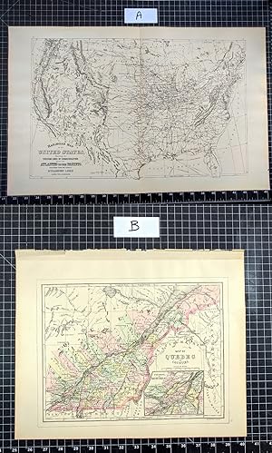
Edité par Chicago : John E. Potter & Company 1894
- Carte
Vendeur : CorgiPack, Fulton, NY, Etats-UnisCorgiPack
Contacter le vendeurVendeur avec une évaluation de 4 étoilesEtat: Occasion - Assez bon
EUR 24,37
Frais de port gratuitsExpédition nationale : Etats-UnisQuantité disponible : 1 disponible(s)
Map. Etat : Very Good. Original lithograph leaf from John E. Potter and Company's, "The New Family Atlas." The Quebec map is hand-colored. Please refer to photo for condition. PLEASE NOTE: If two images are shown they represent the obverse and reverse of the same leaf--not two separate leaves. Overall dimensions approx. 26" x 15….25". This item will be shipped flat.
Edité par Redempti Paradis, Quebec City, PQ 1948
- Édition originale
Vendeur : BISON BOOKS - ABAC/ILAB, Winnipeg, MB, CanadaBISON BOOKS - ABAC/ILAB
Contacter le vendeurVendeur avec une évaluation de 4 étoilesEtat: Occasion
EUR 25,49
EUR 11,39 expéditionExpédition depuis Canada vers Etats-UnisQuantité disponible : 1 disponible(s)
1st edition. pp. 62.,8vo. Card covers a bit age-toned & creased, else in very good cond, Translated from the French. Scarce report. two large folding maps (illustrateur).
 Autres images
Langue : anglais
Vendeur : Librairie Montréal, Saint-Césaire, QC, CanadaLibrairie Montréal
Contacter le vendeurVendeur avec une évaluation de 5 étoilesEtat: Occasion - Bon
EUR 31,86
EUR 15,80 expéditionExpédition depuis Canada vers Etats-UnisQuantité disponible : 1 disponible(s)
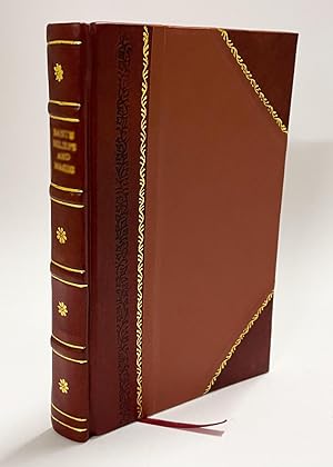
Pas de couverture. Etat : Bon. Montréal, Toronto and London, George N, Tackabury, 1875, large two-pages map with one-page map on other sides, about 26 X 18 inches (large map), printed on both sides, with color. Complete and in good condition showing only a light general tanning to paper (see images).

Edité par District Court East Pennsylvania, USA 1867
- Couverture souple
Vendeur : Maynard & Bradley, Leicester, Royaume-UniMaynard & Bradley
Contacter le vendeurVendeur avec une évaluation de 5 étoilesEtat: Occasion - Assez bon
EUR 45,96
EUR 25,43 expéditionExpédition depuis Royaume-Uni vers Etats-UnisQuantité disponible : 1 disponible(s)
Softcover. Etat : Very Good. c.1867. A well-preserved map, lightly toned commensurate with age, but bearing only a few minor nicks and tears to margins, with no significant damage to the print itself, and colouring remaining clear and attractive. Some marginal thumb marks and nicks, but no major marks to the print itself. Why on… Amazon do most sellers not describe their actual book? Buy with confidence and support a genuine Independent Bricks & Mortar Real Bookshop. We are Maynard & Bradley CAMBO & PBFA(now lapsed) members here in Leicester City Centre. Size: 360 x 300 mm. 1 pages. Item Type: Book. Quantity Available: 1. Shipped Weight: Under 500 grams. Category: Geography & Maps; Britain/UK; 19th century; Pictures of this item not already displayed here available upon request. Inventory No: 18658.

Langue : anglais
- Couverture rigide
- impression à la demande
Vendeur : S N Books World, Delhi, IndeS N Books World
Contacter le vendeurVendeur avec une évaluation de 5 étoilesEtat: Neuf
EUR 21,69
Frais de port gratuitsExpédition depuis Inde vers Etats-UnisQuantité disponible : 18 disponible(s)
LeatherBound. Etat : New. BOOKS ARE EXEMPT FROM IMPORT DUTIES AND TARIFFS; NO EXTRA CHARGES APPLY. Leather Binding on Spine and Corners with Golden leaf printing on spine. Bound in genuine leather with Satin ribbon page markers and Spine with raised gilt bands. A perfect gift for your loved ones. Reprinted from 1878 edition. NO…changes have been made to the original text. This is NOT a retyped or an ocr'd reprint. Illustrations, Index, if any, are included in black and white. Each page is checked manually before printing. As this print on demand book is reprinted from a very old book, there could be some missing or flawed pages, but we always try to make the book as complete as possible. Fold-outs, if any, are not part of the book. If the original book was published in multiple volumes then this reprint is of only one volume, not the whole set and contains approximately 31 pages. IF YOU WISH TO ORDER PARTICULAR VOLUME OR ALL THE VOLUMES YOU CAN CONTACT US. Resized as per current standards. Sewing binding for longer life, where the book block is actually sewn (smythe sewn/section sewn) with thread before binding which results in a more durable type of binding. Language: English.
Langue : anglais
- Couverture rigide
- impression à la demande
Vendeur : S N Books World, Delhi, IndeS N Books World
Contacter le vendeurVendeur avec une évaluation de 5 étoilesEtat: Neuf
EUR 21,69
Frais de port gratuitsExpédition depuis Inde vers Etats-UnisQuantité disponible : 18 disponible(s)
LeatherBound. Etat : New. BOOKS ARE EXEMPT FROM IMPORT DUTIES AND TARIFFS; NO EXTRA CHARGES APPLY. Leather Binding on Spine and Corners with Golden leaf printing on spine. Bound in genuine leather with Satin ribbon page markers and Spine with raised gilt bands. A perfect gift for your loved ones. Reprinted from 1877 edition. NO…changes have been made to the original text. This is NOT a retyped or an ocr'd reprint. Illustrations, Index, if any, are included in black and white. Each page is checked manually before printing. As this print on demand book is reprinted from a very old book, there could be some missing or flawed pages, but we always try to make the book as complete as possible. Fold-outs, if any, are not part of the book. If the original book was published in multiple volumes then this reprint is of only one volume, not the whole set and contains approximately 40 pages. IF YOU WISH TO ORDER PARTICULAR VOLUME OR ALL THE VOLUMES YOU CAN CONTACT US. Resized as per current standards. Sewing binding for longer life, where the book block is actually sewn (smythe sewn/section sewn) with thread before binding which results in a more durable type of binding. Language: English.

Vendeur : Art Source International Inc., Boulder, CO, Etats-UnisArt Source International Inc.
Contacter le vendeurVendeur avec une évaluation de 5 étoilesEtat: Occasion
EUR 40,69
EUR 14,05 expéditionExpédition nationale : Etats-UnisQuantité disponible : 3 disponible(s)
This map was made by S. Augustus Mitchell for "Mitchells New General Atlas" published in 1885, by WM. M. Bradley & Co. The well maintained maps in this atlas feature Mitchell's characteristic pastel coloring and abundant details of geographical features. Quebec in counties, with an inset map of the environs of Montreal is illust…rated. Details include the names of counties, cities, towns, transportation routes, mountain ranges, rivers and lakes. These 1885 maps offer a fascinating perspective of areas that have since undergone significant growth and change, in addition to their value as great examples of Mitchell's work. This map measures 12 inches by 9 inches.

Vendeur : Art Source International Inc., Boulder, CO, Etats-UnisArt Source International Inc.
Contacter le vendeurVendeur avec une évaluation de 5 étoilesEtat: Occasion
EUR 40,69
EUR 14,05 expéditionExpédition nationale : Etats-UnisQuantité disponible : 2 disponible(s)
This map was made by S. Augustus Mitchell for "Mitchell's New General Atlas" published in 1887. The well maintained maps in this atlas feature Mitchell's characteristic pastel coloring and abundant details of geographical features. Quebec is illustrated on this map with an inset showing the environs of Montreal at a greater scal…e than the main map. Details include the names of counties, important towns, rivers, lakes, and railroads. Counties are distinguished by color. These 1887 maps offer a fascinating perspective of areas that have since undergone significant growth and change, in addition to their value as great examples of Mitchell's work. This map measures 13.25 inches by 10.5 inches.

Vendeur : Art Source International Inc., Boulder, CO, Etats-UnisArt Source International Inc.
Contacter le vendeurVendeur avec une évaluation de 5 étoilesEtat: Occasion
EUR 45,21
EUR 14,05 expéditionExpédition nationale : Etats-UnisQuantité disponible : 3 disponible(s)
This map was made my S. Augustus Mitchell in 1872. The traditional ivy border, and hand coloring make this map beautiful. This map illustrates Quebec in counties distinguised by pastel coloring. An inset map of the environs of Montreal. Topographical features, cities, towns and transportation routes are dipicted in detail as wel…l. This map measures 11 inches by 9 inches.

Vendeur : Art Source International Inc., Boulder, CO, Etats-UnisArt Source International Inc.
Contacter le vendeurVendeur avec une évaluation de 5 étoilesEtat: Occasion
EUR 45,21
EUR 14,05 expéditionExpédition nationale : Etats-UnisQuantité disponible : 2 disponible(s)
This map of Quebec (with an inset map of the Environs of Montreal) was made by S. Augustus Mitchell for "Mitchells New General Atlas" published in 1888, by WM. M. Bradley & Co. The well maintained maps in this atlas feature Mitchell's characteristic pastel coloring and abundant details of geographical features. Details include t…he names of counties, cities, towns, transportation routes, mountain ranges, rivers and lakes. These 1888 maps offer a fascinating perspective of areas that have since undergone significant growth and change, in addition to their value as great examples of Mitchell's work. This map measures 13.5 inches by 10.75 inches.

Vendeur : Art Source International Inc., Boulder, CO, Etats-UnisArt Source International Inc.
Contacter le vendeurVendeur avec une évaluation de 5 étoilesEtat: Occasion
EUR 49,73
EUR 14,05 expéditionExpédition nationale : Etats-UnisQuantité disponible : 2 disponible(s)
This hand colored map was made for "Mitchells New General Atlas" published in 1877 by S. Augustus Mitchell. Quebec is illustrated on this map. The environs of Montreal are shown in an inset. Counties are highlighted by color. Other details include the names of counties and important cities, major roads, rivers, and lakes. This m…ap measures 13.5 inches by 10.5 inches.

Vendeur : Art Source International Inc., Boulder, CO, Etats-UnisArt Source International Inc.
Contacter le vendeurVendeur avec une évaluation de 5 étoilesEtat: Occasion
EUR 49,73
EUR 14,05 expéditionExpédition nationale : Etats-UnisQuantité disponible : 1 disponible(s)
This map came from Mitchells New General Atlas, 1883.The traditional ivy border, and hand coloring make this map beautiful.Very Frameable. Has inset map of Montreal. This map measures 13.5 inches by 10.5 inches.

Vendeur : Art Source International Inc., Boulder, CO, Etats-UnisArt Source International Inc.
Contacter le vendeurVendeur avec une évaluation de 5 étoilesEtat: Occasion
EUR 49,73
EUR 14,05 expéditionExpédition nationale : Etats-UnisQuantité disponible : 1 disponible(s)
This map of Quebec was produced by Augustus Mitchell in 1879 for his New General Atlas. Highlights of this map are Mitchells traditional grapevine border, characteristic pastel coloring and abundant details of geographical features. This 1879 map offers a fascinating perspective of areas that have since undergone significant gro…wth and change, in addition to the value as great examples of Mitchell's classic map-making style. This map measures 13.5 inches by 11 inches.

Vendeur : Art Source International Inc., Boulder, CO, Etats-UnisArt Source International Inc.
Contacter le vendeurVendeur avec une évaluation de 5 étoilesEtat: Occasion
EUR 54,25
EUR 14,05 expéditionExpédition nationale : Etats-UnisQuantité disponible : 2 disponible(s)
This map was made by S. Augustus Mitchell for "Mitchells New General Atlas" published in 1884, by WM. M. Bradley & Co. The well maintained maps in this atlas feature Mitchell's characteristic pastel coloring and abundant geographical features. Details include the names of countries, regions, cities, towns, transportation routes,… rivers, lakes, and mountain ranges. Regions are distinguished by color. These 1884 maps offer a fascinating perspective of areas that have since undergone significant growth and change, in addition to their value as great examples of Mitchell's work. This map measures 13.25 inches by 10.5 inches.

Vendeur : Art Source International Inc., Boulder, CO, Etats-UnisArt Source International Inc.
Contacter le vendeurVendeur avec une évaluation de 5 étoilesEtat: Occasion
EUR 58,77
EUR 14,05 expéditionExpédition nationale : Etats-UnisQuantité disponible : 3 disponible(s)
This map was produced by Augustus Mitchell in 1878 for his New General Atlas. Highlights of this map are Mitchells traditional grapevine border, characteristic pastel coloring and abundant details of geographical features. Quebec is beautifully illustrated on this map with nice inset map of "Environs of Montreal". Towns and surr…ounding neighborhoods are distinguished by color. This 1878 map offers a fascinating perspective of areas that have since undergone significant growth and change, in addition to the value as great examples of Mitchell's classic mapmaking style. This map measures 13.33 inches by 10.5 inches.

Vendeur : Art Source International Inc., Boulder, CO, Etats-UnisArt Source International Inc.
Contacter le vendeurVendeur avec une évaluation de 5 étoilesEtat: Occasion
EUR 58,77
EUR 14,05 expéditionExpédition nationale : Etats-UnisQuantité disponible : 3 disponible(s)
This map came from Mitchells New General Atlas, 1881.This map shows major railroads, water bodies, and towns.Decorative ivy border, and nice colorful detail. Would looknice framed! Has detailed inset map of Montreal. This map measures 10.5 inches by 13.5 inches.

Vendeur : Art Source International Inc., Boulder, CO, Etats-UnisArt Source International Inc.
Contacter le vendeurVendeur avec une évaluation de 5 étoilesEtat: Occasion
EUR 58,77
EUR 14,05 expéditionExpédition nationale : Etats-UnisQuantité disponible : 2 disponible(s)
S. Augustus Mitchell Jr. made this hand colored map for Mitchells New General Atlas in 1870. Quebec is illustrated on this map. Regions are distinguished by bright pastel colors. Lakes, mountains, rivers, important cities and countries are identified. An inset shows the environs of Quebec. This map measures 13.25 inches by 10.75… inches.

Vendeur : Art Source International Inc., Boulder, CO, Etats-UnisArt Source International Inc.
Contacter le vendeurVendeur avec une évaluation de 5 étoilesEtat: Occasion
EUR 58,77
EUR 14,05 expéditionExpédition nationale : Etats-UnisQuantité disponible : 2 disponible(s)
This map was produced by S. Augustus Mitchell in 1874 for his New General Atlas. This map shows Mitchell's traditional grape vine border, characteristic pastel coloring and abundant details of geographical features. The Provenance of Quebec is illustrated on this map. Counties are distinguished by color. These 1874 maps offer a…fascinating perspective of areas that have since undergone significant growth and change, in addition to their value as great examples of Mitchell's work This map measures 14 inches by 11 inches.
Edité par S. Augustus Mitchell, Philadelphia 1877
- Carte
Vendeur : Alexandre Antique Prints, Maps & Books, Toronto, ON, CanadaAlexandre Antique Prints, Maps & Books
Contacter le vendeurVendeur avec une évaluation de 4 étoilesEtat: Occasion - Assez bon
EUR 113,02
EUR 5,27 expéditionExpédition depuis Canada vers Etats-UnisQuantité disponible : 1 disponible(s)
Etat : Very Good. An attractive Map of Quebec, showing its counties and the St. Lawrence River. With an inset map showing the Environs of Montreal., Size : 270x339 (mm), 10.63x13.35 (Inches), Printed in Color with Some Hand Coloring.
Edité par Philadelphia, 1867
- Estampe
Vendeur : libreria antiquaria perini Sas di Perini, Verona, VR, Italielibreria antiquaria perini Sas di Perini
Contacter le vendeurVendeur avec une évaluation de 5 étoilesEtat: Occasion
EUR 100,00
EUR 40,00 expéditionExpédition depuis Italie vers Etats-UnisQuantité disponible : 1 disponible(s)
Incisione in acciaio, dipinta d'epoca a tutto campo, 290x355. Carta del territorio tutto inquadrato entro bordura decorativa con vitigno intrecciato. Buon esemplare ben conservato, minime macchie marginali e numero 10 con lievi aloni agli angoli inferiori e antica numerazione a inchiostro all' angolo inferiore di destra.
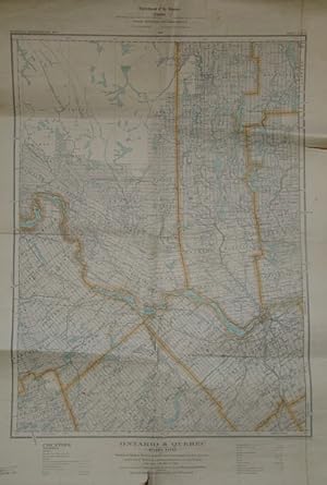
Edité par Department of the Interior, Government of Canada, Ottawa 1929
- Édition originale
Vendeur : RareNonFiction, IOBA, Ladysmith, BC, CanadaRareNonFiction, IOBA
Contacter le vendeurVendeur avec une évaluation de 5 étoilesMembre d’une association professionnelle : IOBA
Etat: Occasion - Moyen
EUR 135,58
EUR 17,55 expéditionExpédition depuis Canada vers Etats-UnisQuantité disponible : 1 disponible(s)
Map. Etat : Fair. First Edition. Approx. 23" x 33" standard topographical map. Coloured. Library markings. Two-inch opening to bottom edge. Shorter openings to top and right edges. Somewhat above-average wear and soiling.

Vendeur : Art Source International Inc., Boulder, CO, Etats-UnisArt Source International Inc.
Contacter le vendeurVendeur avec une évaluation de 5 étoilesEtat: Occasion
EUR 67,81
EUR 14,05 expéditionExpédition nationale : Etats-UnisQuantité disponible : 2 disponible(s)
This hand colored map was made for "Mitchells New General Atlas" published in 1868 by S. Augustus Mitchell, Jr. Quebec is illustrated on this map. An inset shows Montreal at a greater scale than the main map. Counties are distinguished by color. Other details include the names of counties, and important cities, railroads, major…roads,and rivers. The pastel coloring in this atlas is very beautiful and more muted than typical. This map measures 13.5 inches by 10.75 inches.
 Autres images
- Couverture rigide
- impression à la demande
Vendeur : Gyan Books Pvt. Ltd., Delhi, IndeGyan Books Pvt. Ltd.
Contacter le vendeurVendeur avec une évaluation de 5 étoilesEtat: Neuf
EUR 66,58
Frais de port gratuitsExpédition depuis Inde vers Etats-UnisQuantité disponible : Plus de 20 disponibles
Leather Bound. Etat : New. Language: English. Language: English. Presenting an Exquisite Leather-Bound Edition, expertly crafted with Original Natural Leather that gracefully adorns the spine and corners. The allure continues with Golden Leaf Printing that adds a touch of elegance, while Hand Embossing on the rounded spine lends… an artistic flair. This masterpiece has been meticulously reprinted in 2024, utilizing the invaluable guidance of the original edition published many years ago in 1877. The contents of this book are presented in classic black and white. Its durability is ensured through a meticulous sewing binding technique, enhancing its longevity. Imprinted on top-tier quality paper. A team of professionals has expertly processed each page, delicately preserving its content without alteration. Due to the vintage nature of these books, every page has been manually restored for legibility. However, in certain instances, occasional blurriness, missing segments, or faint black spots might persist. We sincerely hope for your understanding of the challenges we faced with these books. Recognizing their significance for readers seeking insight into our historical treasure, we've diligently restored and reissued them. Our intention is to offer this valuable resource once again. We eagerly await your feedback, hoping that you'll find it appealing and will generously share your thoughts and recommendations. Lang: - English, Pages: - 447, Print on Demand. If it is a multi-volume set, then it is only a single volume. We are specialised in Customisation of books, if you wish to opt different color leather binding, you may contact us. This service is chargeable. Product Disclaimer: Kindly be informed that, owing to the inherent nature of leather as a natural material, minor discolorations or textural variations may be perceptible. Explore the FOLIO EDITION (12x19 Inches): Available Upon Request. 447 447.


