Montant total (1 article articles) :
Destination de la commande :

map scotland covering western isles de john bartholomew (1 résultats)
Commentaires
Passer aux résultats principaux de la recherche
Filtres de recherche
Type d'article
- Tous les types de produits
- Livres (1)
- Magazines & Périodiques (Aucun autre résultat ne correspond ŕ ces critčres)
- Bandes dessinées (Aucun autre résultat ne correspond ŕ ces critčres)
- Partitions de musique (Aucun autre résultat ne correspond ŕ ces critčres)
- Art, Affiches et Gravures (Aucun autre résultat ne correspond ŕ ces critčres)
- Photographies (Aucun autre résultat ne correspond ŕ ces critčres)
- Cartes (Aucun autre résultat ne correspond ŕ ces critčres)
- Manuscrits & Papiers anciens (Aucun autre résultat ne correspond ŕ ces critčres)
Etat En savoir plus
- Neuf (Aucun autre résultat ne correspond ŕ ces critčres)
- Comme neuf, Trčs bon ou Bon (Aucun autre résultat ne correspond ŕ ces critčres)
- Assez bon ou satisfaisant (1)
- Moyen ou mauvais (Aucun autre résultat ne correspond ŕ ces critčres)
- Conformément ŕ la description (Aucun autre résultat ne correspond ŕ ces critčres)
Reliure
- Toutes
- Couverture rigide (Aucun autre résultat ne correspond ŕ ces critčres)
- Couverture souple (1)
Particularités
- Ed. originale (1)
- Signé (Aucun autre résultat ne correspond ŕ ces critčres)
- Jaquette (Aucun autre résultat ne correspond ŕ ces critčres)
- Avec images (1)
- Sans impressions ŕ la demande (1)
Langue (1)
Prix
- Tous les prix
- Moins de EUR 20 (Aucun autre résultat ne correspond ŕ ces critčres)
- EUR 20 ŕ EUR 45
- Plus de EUR 45 (Aucun autre résultat ne correspond ŕ ces critčres)
Livraison gratuite
- Livraison gratuite ŕ destination de France (Aucun autre résultat ne correspond ŕ ces critčres)
Pays
Evaluation du vendeur
-
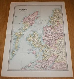
Map of Scotland (Section 1) covering the Western Isles or Outer Hebrides, Skye, Rum and parts of North West Scotland - Sheet 19 Disbound from the 1890 'The Library Reference Atlas of the World'
Edité par Macmillan and Co., London, 1890
Vendeur : Bailgate Books Ltd, Doncaster, Royaume-Uni
Évaluation du vendeur 5 sur 5 étoiles

Edition originale
EUR 33,07
Autre deviseEUR 9,17 expédition depuis Royaume-Uni vers FranceQuantité disponible : 1 disponible(s)
Ajouter au panierSoftcover. Etat : Very Good. Etat de la jaquette : No Dust Jacket. First Edition. Single disbound coloured map sheet from John Bartholomew's Library Reference Atlas. Section 1 only of 4 covering Scotland. Approx size 46 x 35 cm, horizontal centre fold. Corners lightly worn. Map is clean, crisp, clear and bright. Sheet covers Outer Hebrides and parts of Inner Hebrides and North West Scotland including: Lewis, Harris, North and South Uist, Barra, Skye, Canna, Rum, Eigg, Coll, Ullapool, Cape Wrath, parts of Sutherland, Ross, Inverness and Argyll, Loch Linnhe, Loch Lochy, Loch Broom, North Minch, etc. No dust jacket, as published. Quantity Available: 1. Shipped Weight: under 1 kg. Pictures of this item not already displayed here available upon request. Inventory No: 45020124007. All our books are sent by tracked mail.