Montant total (1 article articles) :
Destination de la commande :

new correct large draught plymouth de collins captain greenvile (1 résultats)
Commentaires
Passer aux résultats principaux de la recherche
Filtres de recherche
Type d'article
- Tous les types de produits
- Livres (Aucun autre résultat ne correspond ŕ ces critčres)
- Magazines & Périodiques (Aucun autre résultat ne correspond ŕ ces critčres)
- Bandes dessinées (Aucun autre résultat ne correspond ŕ ces critčres)
- Partitions de musique (Aucun autre résultat ne correspond ŕ ces critčres)
- Art, Affiches et Gravures (Aucun autre résultat ne correspond ŕ ces critčres)
- Photographies (Aucun autre résultat ne correspond ŕ ces critčres)
- Cartes (1)
- Manuscrits & Papiers anciens (Aucun autre résultat ne correspond ŕ ces critčres)
Etat En savoir plus
- Neuf (Aucun autre résultat ne correspond ŕ ces critčres)
- Comme neuf, Trčs bon ou Bon (Aucun autre résultat ne correspond ŕ ces critčres)
- Assez bon ou satisfaisant (1)
- Moyen ou mauvais (Aucun autre résultat ne correspond ŕ ces critčres)
- Conformément ŕ la description (Aucun autre résultat ne correspond ŕ ces critčres)
Reliure
- Toutes
- Couverture rigide (Aucun autre résultat ne correspond ŕ ces critčres)
- Couverture souple (Aucun autre résultat ne correspond ŕ ces critčres)
Particularités
- Ed. originale (1)
- Signé (Aucun autre résultat ne correspond ŕ ces critčres)
- Jaquette (Aucun autre résultat ne correspond ŕ ces critčres)
- Avec images (1)
- Sans impressions ŕ la demande (1)
Langue (1)
Prix
- Tous les prix
- Moins de EUR 20 (Aucun autre résultat ne correspond ŕ ces critčres)
- EUR 20 ŕ EUR 45 (Aucun autre résultat ne correspond ŕ ces critčres)
- Plus de EUR 45
Livraison gratuite
- Livraison gratuite ŕ destination de Etats-Unis (Aucun autre résultat ne correspond ŕ ces critčres)
Pays
Evaluation du vendeur
-
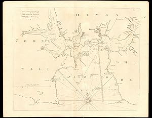
A new & correct large Draught of Plymouth Sound, Catt Water and Ham Owse
Date d'édition : 1774
Vendeur : Antiqua Print Gallery, London, Royaume-Uni
Évaluation du vendeur 3 sur 5 étoiles

Carte Edition originale
EUR 495,44
Autre deviseEUR 11,45 expédition depuis Royaume-Uni vers Etats-UnisQuantité disponible : 1 disponible(s)
Ajouter au panierEtat : Good. PLYMOUTH SOUND, Cattewater & Hamoaze sea chart by Capt G. COLLINS c1774 map. Decorative antique eighteenth century copperplate nautical sea chart, printed on thick paper; Captain Greenvile (or Greenville) Collins. Collins was an officer of the Royal Navy and prominent hydrographer, who was commissioned by King Charles II in 1676 and appointed by Samuel Pepys (then Secretary to the Admiralty), to chart the coasts of Great Britain. The resulting atlas - Great Britain's Coasting Pilot - was the first original sea atlas to be produced by an Englishman. Prior to publication of these maps, nautical charts were often defective, and there was no centralised system for collecting and disseminating the better maps made by experienced seamen. In 1681, Collins gained the king's preferment to survey the country's coasts. The Admiralty supplied Collins with the 8-gun yacht HMSMerlin for the first two years and later the yacht HMSMonmouth until 1686. His work was carried out under the supervision of Trinity House, who also supported the project financially. Samuel Pepys insisted that Collins be made a younger brother of Trinity House. Collins spent seven years on the survey, the first edition of which was published in 1693, as "Great Britain's Coasting Pilot". The charts, while not completely accurate, were an enormous advance on anything before them, entitling Collins to rank as not only one of the earliest, but also among the best of English hydrographers. Twenty-one further editions were published during the eighteenth century. (Published after 1774, possibly in 1792. The atlas within which this map was printed (see provenance) was first published in 1693 with a number of later editions published through the eighteenth century. The publication date stated on the title page of this edition of the atlas is "MDCCLXCII", which is unintelligible and erroneous as it does not conform to standard notation for Roman Numerals. The text within the book from which the map was extracted refers to tidal variations up to the year 1774, hence we state the publication date as after 1774. This edition of the atlas does not appear in the English Short Title Catalogue. The publisher is stated to be "Mount & Davidson", which differs from the publisher of other editions through the early part of the 18th century, which is stated to be "Mount & Page". Mount & Davidson appear to have been active as publishers in the 1780's and early 1790's. A publication date of 1792 (MDCCXCII) would be consistent with stated year of publication if the "L" had been erroneously inserted.). 63.5 x 51.0cm, 25 x 20 inches; this is a folding map. Condition: Good. Please contact us if you would like to arrange to view this map. There is nothing printed on the reverse side, which is plain. A detailed sea chart of Plymouth Sound, the Hamoaze and the Cattewater. In addition to Plymouth itself, a number of other towns, villages and coastal features are marked including Cawsand, Millbrook, Hooe, Stonehouse & Oreston.