Montant total (1 article articles) :
Destination de la commande :

new universal atlas containing maps de mitchell augustus (7 rťsultats)
Commentaires
Passer aux rťsultats principaux de la recherche
Filtres de recherche
Type d'article
- Tous les types de produits
- Livres (6)
- Magazines & Pťriodiques (Aucun autre rťsultat ne correspond ŗ ces critŤres)
- Bandes dessinťes (Aucun autre rťsultat ne correspond ŗ ces critŤres)
- Partitions de musique (Aucun autre rťsultat ne correspond ŗ ces critŤres)
- Art, Affiches et Gravures (Aucun autre rťsultat ne correspond ŗ ces critŤres)
- Photographies (Aucun autre rťsultat ne correspond ŗ ces critŤres)
- Cartes (1)
- Manuscrits & Papiers anciens (Aucun autre rťsultat ne correspond ŗ ces critŤres)
Etat En savoir plus
- Neuf (Aucun autre rťsultat ne correspond ŗ ces critŤres)
- Comme neuf, TrŤs bon ou Bon (Aucun autre rťsultat ne correspond ŗ ces critŤres)
- Assez bon ou satisfaisant (Aucun autre rťsultat ne correspond ŗ ces critŤres)
- Moyen ou mauvais (Aucun autre rťsultat ne correspond ŗ ces critŤres)
- Conformťment ŗ la description (7)
Reliure
- Toutes
- Couverture rigide (5)
- Couverture souple (Aucun autre rťsultat ne correspond ŗ ces critŤres)
Particularitťs
- Ed. originale (1)
- Signť (Aucun autre rťsultat ne correspond ŗ ces critŤres)
- Jaquette (Aucun autre rťsultat ne correspond ŗ ces critŤres)
- Avec images (6)
- Sans impressions ŗ la demande (7)
Langue (1)
Prix
- Tous les prix
- Moins de EUR 20 (Aucun autre rťsultat ne correspond ŗ ces critŤres)
- EUR 20 ŗ EUR 40 (Aucun autre rťsultat ne correspond ŗ ces critŤres)
- Plus de EUR 40
Livraison gratuite
- Livraison gratuite ŗ destination de France (Aucun autre rťsultat ne correspond ŗ ces critŤres)
Pays
Evaluation du vendeur
-
A New Universal Atlas Containing Maps of the Various Empires, Kingdoms, States and Republics of the World. With a Special Map of Each of the United States, Plans of Cities, &c
Editť par Thomas, Cowperthwait & Co, Philadelphia, 1852
Vendeur : James Cummins Bookseller, ABAA, New York, NY, Etats-Unis
Membre d'association : ABAA ILAB
…valuation du vendeur 4 sur 5 ťtoiles

EUR 8†728,03
Autre deviseEUR 33,90 expťdition depuis Etats-Unis vers FranceQuantitť disponible : 1 disponible(s)
Ajouter au panierChromolithograph title, hand-colored frontispiece, 73 hand-colored lithographic maps. 1 vols. Folio. Mitchell & Sons first published their NEW UNIVERSAL ATLAS in 1846 (having acquired Tanner's NEW UNIVERSAL ATLAS in 1845) and printed it several times subsequently until 1850 when the firm sold the rights to Cowperthwait & Co. of Philadelphia, who published it until 1856, continually adding to and editing the hand-colored maps. Despite the attribute "Universal" in the title, the Atlas clearly concentrates on America, with 43 maps of the continent, and features a large, double-page transcontinental map of the U.S; and this 1852 Cowperthwait edition is the first to show counties in California and New Mexico. Phillips, 809; Ristow, pp.311-13; Rumsey, p.240 Half red morocco in period style, original marbled boards, with printed label on upper cover, very clean Chromolithograph title, hand-colored frontispiece, 73 hand-colored lithographic maps. 1 vols. Folio.
-
A New Universal Atlas Containing Maps of the Various Empires, Kingdoms, States and Republics of the World
Editť par Philadelphia, Philadelphia, 1846
Vendeur : High Ridge Books, Inc. - ABAA, South Deerfield, MA, Etats-Unis
Membre d'association : ABAA ESA ILAB SNEAB
…valuation du vendeur 5 sur 5 ťtoiles

Edition originale
EUR 4†800,42
Autre deviseEUR 29,66 expťdition depuis Etats-Unis vers FranceQuantitť disponible : 1 disponible(s)
Ajouter au panier47x37 cm. First edition, first issue, with the maps having been taken from the plates for Henry Tanner's Universal Atlas. Overall, a very good copy, with 1/2 original leather with morocco gilt label, some wear at extremities, front board is detached, backstrip loose, internally very good with scattered very light soiling in the margins of a small number of maps. 72 maps, including the single-page map of Texas which was only included in the first issue of this atlas. While Mitchell's name has been inserted on all maps, some still have Tanner's name as well. Most of the maps are copyrighted by H. N. Burroughs, in 1846.
-
A New Universal Atlas containing Maps of the Various Empires, Kingdoms, States, and Republics of the World. With a special map of each of the United States, plans of cities &c.
Editť par Philadelphia: S. Augustus Mitchell, 1847., 1847
Vendeur : Arader Galleries - AraderNYC, New York, NY, Etats-Unis
…valuation du vendeur 5 sur 5 ťtoiles
EUR 3†840,34
Autre deviseEUR 29,66 expťdition depuis Etats-Unis vers FranceQuantitť disponible : 1 disponible(s)
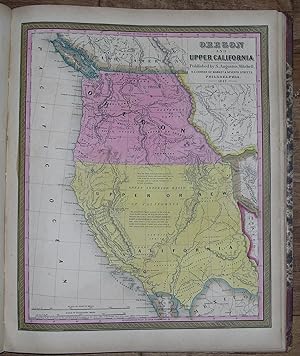
Ajouter au panierFolio, (17 3/8 x 14 Ĺ inches). Vignette title page (toned with one or two spots). Hand-colored lithographed frontispiece "Heights of the Principal Mountains in the World" and "Lengths of the Principal Rivers in the World" (Plate 73), 72 fine lithographed maps with original hand-color in full (lower corner of Plate 14 torn away, occasional spotting and browning). Original publisher's half red roan, marbled boards, lettered in gilt (hinges cracked but holding, overall quite worn with loss). Provenance: Contemporary pen trials to recto of front free endpaper. First published by Mitchell in 1846 after having acquired the rights to Henry Schenk Tanner's "New Universal Atlas" from Carey & Hart who had published editions in 1843 and 1844. However Mitchell changed many of the maps, changed the copperplates to lithography, and then issued the atlas at least once a year until 1850, when he sold the rights to Thomas, Cowperthwait & Company. Thereafter the rights were bought and sold several times, with the atlas being published until at least 1860. "Many maps bear the imprint of S. Augustus Mitchell, and the copyright notice of H. N. Burroughs, or of H. S. Tanner. This atlas is a reissue of Tanner's New Universal Atlas which continued to be published for some years as Mitchell's New Universal Atlas, without reference to Tanner. Includes a map of Oregon and Upper California not called for in the table of contents. [Plate] No. 72, Lengths of the principal rivers in the world [and] Heights of the principal mountains.is bound as [the] frontispiece. The engraved title page has a vignette, 'First landing of Columbus in the New World.'" Phillips Atlases 797. This copy differs from Phillips's in the following issue points: the map of Oregon and Upper California is in fact listed in the Table of Contents as Plate 36; however, the plate itself is unnumbered and the numbering of the subsequent plates is off by one with respect to the Table of Contents. Here, the frontispiece showing the heights of the world's mountains and the lengths of the world's rivers is numbered 73, rather than 72. Title page bears the 1844 copyright notice of Carey & Hart, but most maps bear that of H. N. Burroughs. Catalogued by Megan Scauri.
-
New Universal Atlas of the World Containing Maps of the various Empires, Kingdoms, States and Republics Of The World. With a special map of each of the United States, Plans of Cities &c. Comprehended in seventy sheets and forming a series of One Hundred And Seventeen Maps, Plans And Sections
Editť par Cowperthwait & Co, Philadelphia, 1852
Vendeur : Heritage Book Shop, ABAA, Beverly Hills, CA, Etats-Unis
Membre d'association : ABAA ILAB
…valuation du vendeur 4 sur 5 ťtoiles
EUR 6†546,03
Autre deviseEUR 42,37 expťdition depuis Etats-Unis vers FranceQuantitť disponible : 1 disponible(s)
Ajouter au panierComplete with seventy-three full colored maps, one of which is double-paged, color frontispiece, vignette title-page and table of contents, heightened in gilt. Folio (17 x 14 inches; 430 x 355 mm). Half red morocco over marbled boards. Front board with red morocco label, lettered in gilt. Binding scuffed and bumped. Hinges professionally repaired. Some toning throughout, mainly to blank versos of maps and margin edges, only occasionally affecting the maps. Closed tear to front free endpaper. A few instances of foxing on maps, mainly to map 51 "Holland and Belgium." A small dark spot in Buenos Ayres on map 44. A small piece scraped off of map 73, "Oceana" but not making a hole all the way through. Also a marginal closed tear to this map, professionally repaired. Overall a very good copy. This atlas was first published in 1846 by Mitchell & Sons after acquiring the rights to Tanner's New Universal Atlas in 1845. Mitchell & Sons reprinted it several times until 1850 when they sold the rights to Cowperthwait & Co. of Philadelphia, who published it until 1856. During this time the atlas was further expanded and edited. Over half of this atlas deals with the Americas and features the double-page "A New Map of the United States of America." Within this map of the USA is a detailed inset of "The Gold Regions of California." The present edition is the first to show counties in California and New Mexico. Howes. Streeter. HBS 65704. $7,500.
-

A New Universal Atlas Containing Maps of the various Empires, Kingdoms, States and Republics of the World.
Editť par Philadelphia: S. Augustus Mitchell, 1848., 1848
Vendeur : Arader Galleries - AraderNYC, New York, NY, Etats-Unis
…valuation du vendeur 5 sur 5 ťtoiles
EUR 3†491,21
Autre deviseEUR 29,66 expťdition depuis Etats-Unis vers FranceQuantitť disponible : 1 disponible(s)
Ajouter au panierFolio (17 2/8 x 14 inches). Lithographed vignette title-page. Hand-coloured lithographed frontispiece showing the lengths of rivers and the heights of mountains, a fine lithographed double-hemisphere map of the world and 70 full-page maps all with original hand-colour in full and engraved by Peter S. Duval of Philadelphia. Original half red morocco, marbled paper boards, gilt (extremities quite worn). Provenance: with the pencil trials of a young John H williams of Petersville Frederick County on the endpapers. First published by Mitchell in 1846 after having acquired the rights to Henry Schenk Tanner's "New Universal Atlas" from Carey & Hart who had published editions in 1843 and 1844. However Mitchell changed many of the maps, changed the copperplates to lithography, and then issued the atlas at least once a year until 1850, when he sold the rights to Thomas, Cowperthwait & Company. Thereafter the rights were bought and sold several times, with the atlas being published until at least 1860. Catalogued by Kate Hunter.
-

New Universal Atlas Containing Maps of the various Empires, Kingdoms, States and Republics of the World.
Editť par Mitchell S. Augustus, Philadelphia, 1846
Vendeur : Antiquariat Reinhold Berg eK Inh. R.Berg, Regensburg, Allemagne
Membre d'association : ILAB VDA
…valuation du vendeur 5 sur 5 ťtoiles
Carte
EUR 120
Autre deviseEUR 18 expťdition depuis Allemagne vers FranceQuantitť disponible : 1 disponible(s)
Ajouter au panierOriginal antique lithograph. Title page with an lithograph from the first landing of Columbus in the New World, engraved by Humphrys. Paper browned, mainly at the edges. A backed tear on the right edge. 44.2 x 34,5 cm (17.5 x 13,5 inches).
-
A NEW UNIVERSAL ATLAS CONTAINING MAPS OF THE VARIOUS EMPIRES, KINGDOMS, STATES AND REPUBLICS OF THE WORLD. WITH A SPECIAL MAP OF EACH OF THE UNITED STATES, PLANS OF CITIES, &c.
Editť par Philadelphia: Thomas, Cowperthwait & Co., 1852., 1852
Vendeur : William Reese Company, New York, NY, Etats-Unis
Membre d'association : ABAA ESA ILAB SNEAB
…valuation du vendeur 3 sur 5 ťtoiles

EUR 6†546,03
Autre deviseEUR 34,74 expťdition depuis Etats-Unis vers FranceQuantitť disponible : 1 disponible(s)
Ajouter au panierChromolithographic title with large vignette; handcolored frontispiece of heights of principal mountains and lengths of principal rivers; contents list printed in red, black, and gold; seventy-three handcolored lithographic maps, charts, and city plans (one double-page). Folio. Publisher's three-quarter red morocco and marbled boards, spine ruled in gilt, morocco label lettered in gilt on front board. Binding worn and rubbed, front hinge tender. Contemporary bookplate on front pastedown. Some toning but generally clean internally. Very good overall. A famous atlas, with handcolored maps of all the individual states and territories, with the map of California showing counties in California and New Mexico for the first time, and with the locations of Native American tribes shown in several western states and territories. Despite its title, the atlas concentrates to a marked degree on the American continent, with forty-three maps of the area, including a fine double-page coast-to-coast map of the United States. S. Augustus Mitchell and his sons were the leading publishers of maps in the United States during most of the 19th century. Mitchell had come to Philadelphia round 1830 with the intention of improving the standard of geography textbooks, Philadelphia then being the leading city in America for cartographical publications. A NEW AMERICAN ATLAS, published in 1831, was his first work. In 1845 he acquired the right to Tanner's NEW UNIVERSAL ATLAS (first published in 1836), and in 1846 he published his first edition of the present work. Mitchell continued to publish the atlas until 1850, when he sold the copyright to Cowperthwait & Co. of Philadelphia. Thomas, Cowperthwait & Company published it until 1856, when it was purchased by Charles DeSilver. The Cowperthwait company continued to add, edit, alter, and hand-color the maps. PHILLIPS ATLASES 807. RISTOW, pp.311-13 (ref). RUMSEY 553.