
Montant total (1 article articles) :
Destination de la commande :

nouvelle angleterre nlle york nlle de vaugondy (3 résultats)
Commentaires
Passer aux résultats principaux de la recherche
Filtres de recherche
Type d'article
- Tous les types de produits
- Livres (Aucun autre résultat ne correspond ŕ ces critčres)
- Magazines & Périodiques (Aucun autre résultat ne correspond ŕ ces critčres)
- Bandes dessinées (Aucun autre résultat ne correspond ŕ ces critčres)
- Partitions de musique (Aucun autre résultat ne correspond ŕ ces critčres)
- Art, Affiches et Gravures (1)
- Photographies (Aucun autre résultat ne correspond ŕ ces critčres)
- Cartes (2)
- Manuscrits & Papiers anciens (Aucun autre résultat ne correspond ŕ ces critčres)
Etat En savoir plus
- Neuf (Aucun autre résultat ne correspond ŕ ces critčres)
- Comme neuf, Trčs bon ou Bon (1)
- Assez bon ou satisfaisant (2)
- Moyen ou mauvais (Aucun autre résultat ne correspond ŕ ces critčres)
- Conformément ŕ la description (Aucun autre résultat ne correspond ŕ ces critčres)
Reliure
- Toutes
- Couverture rigide (Aucun autre résultat ne correspond ŕ ces critčres)
- Couverture souple (Aucun autre résultat ne correspond ŕ ces critčres)
Particularités
- Ed. originale (Aucun autre résultat ne correspond ŕ ces critčres)
- Signé (Aucun autre résultat ne correspond ŕ ces critčres)
- Jaquette (Aucun autre résultat ne correspond ŕ ces critčres)
- Avec images (2)
- Sans impressions ŕ la demande (3)
Langue (1)
Prix
- Tous les prix
- Moins de EUR 20 (Aucun autre résultat ne correspond ŕ ces critčres)
- EUR 20 ŕ EUR 45 (Aucun autre résultat ne correspond ŕ ces critčres)
- Plus de EUR 45
Livraison gratuite
- Livraison gratuite ŕ destination de France (Aucun autre résultat ne correspond ŕ ces critčres)
Pays
Evaluation du vendeur
-
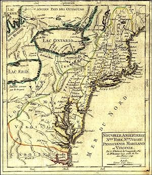
'NOUVELLE ANGLETERRE, NLLE. YORK, NLLE. JERSEY, PENSILVANIE, MARILAND ET VIRGINIE'. Map of the Eastern States, incl. the Great Lakes, reaching south from New England (Maine) to Virginia and Carolina
Edité par Robert de Vaugondy 1748, 1748
Vendeur : Garwood & Voigt, Sevenoaks, Royaume-Uni
Évaluation du vendeur 5 sur 5 étoiles

Carte
EUR 176,87
Autre deviseEUR 27,47 expédition depuis Royaume-Uni vers FranceQuantité disponible : 1 disponible(s)
Ajouter au panierEtat : Fine. 19x16cm. Original outline colour. Excellent condition.
-

Nouvelle Angleterre, NLLE.York NLLE Jersey Pensilvanie Mariland Et Virginie
Edité par Paris, 1748
Vendeur : Alexandre Antique Prints, Maps & Books, Toronto, ON, Canada
Membre d'association : ABAC ILAB
Évaluation du vendeur 5 sur 5 étoiles
Carte
EUR 242,03
Autre deviseEUR 7,26 expédition depuis Canada vers FranceQuantité disponible : 1 disponible(s)
Ajouter au panierEtat : Very Good. Map of Eastern States, Lake Ontario and Lake Erie in mid 18th century., Size : 189x159 (mm), 7.44x6.26 (Inches), Hand Colored.
-

Nouvelle Angleterre, Nlle. York, Nlle Jersey, Pensilvanie, Mariland et Virginie
Edité par Paris, 1749
Art / Affiche / Gravure
EUR 395
Autre deviseEUR 20 expédition depuis Espagne vers FranceQuantité disponible : 1 disponible(s)
Ajouter au panierEtat : ACEPTABLE. Atlas portatif universel et militaire Gilles y Didier Robert de Vaugondy, padre e hijo, fueron famosos cartógrafos franceses del siglo XVIII. Eran descendientes del también cartógrafo Nicolas Sanson de quien heredaron gran parte de su material cartográfico. En 1760, Didier Robert de Vaugondy fue nombrado geógrafo de Luis XV En 1757 publicaron su más famosa obra, el Atlas Universel Formato (cm): 18x20.
