
Montant total (1 article articles) :
Destination de la commande :

original map palaestina part syria de sherman george (1 résultats)
Commentaires
Passer aux résultats principaux de la recherche
Filtres de recherche
Type d'article
- Tous les types de produits
- Livres (Aucun autre résultat ne correspond ŕ ces critčres)
- Magazines & Périodiques (Aucun autre résultat ne correspond ŕ ces critčres)
- Bandes dessinées (Aucun autre résultat ne correspond ŕ ces critčres)
- Partitions de musique (Aucun autre résultat ne correspond ŕ ces critčres)
- Art, Affiches et Gravures (Aucun autre résultat ne correspond ŕ ces critčres)
- Photographies (Aucun autre résultat ne correspond ŕ ces critčres)
- Cartes (1)
- Manuscrits & Papiers anciens (Aucun autre résultat ne correspond ŕ ces critčres)
Etat En savoir plus
- Neuf (Aucun autre résultat ne correspond ŕ ces critčres)
- Comme neuf, Trčs bon ou Bon (Aucun autre résultat ne correspond ŕ ces critčres)
- Assez bon ou satisfaisant (1)
- Moyen ou mauvais (Aucun autre résultat ne correspond ŕ ces critčres)
- Conformément ŕ la description (Aucun autre résultat ne correspond ŕ ces critčres)
Reliure
- Toutes
- Couverture rigide (Aucun autre résultat ne correspond ŕ ces critčres)
- Couverture souple (Aucun autre résultat ne correspond ŕ ces critčres)
Particularités
- Ed. originale (Aucun autre résultat ne correspond ŕ ces critčres)
- Signé (Aucun autre résultat ne correspond ŕ ces critčres)
- Jaquette (Aucun autre résultat ne correspond ŕ ces critčres)
- Avec images (1)
- Sans impressions ŕ la demande (1)
Langue (1)
Prix
- Tous les prix
- Moins de EUR 20 (Aucun autre résultat ne correspond ŕ ces critčres)
- EUR 20 ŕ EUR 45
- Plus de EUR 45 (Aucun autre résultat ne correspond ŕ ces critčres)
Livraison gratuite
- Livraison gratuite ŕ destination de France (Aucun autre résultat ne correspond ŕ ces critčres)
Pays
Evaluation du vendeur
-
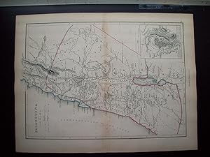
Original Map - "Palaestina with Part of Syria"
Edité par Blanchard and Lea, Philadelphia, PA
Vendeur : Barry Cassidy Rare Books, Sacramento, CA, Etats-Unis
Évaluation du vendeur 5 sur 5 étoiles

Carte
EUR 44,16
Autre deviseEUR 42,87 expédition depuis Etats-Unis vers FranceQuantité disponible : 1 disponible(s)
Ajouter au panierNo Binding. Etat : Collectible-Very Good. Original publisher's hand-colored map of Palaestina (Palestine) and part of ancient Syria. Regions such as Judaea, Idumaea (Edom), Samaria, Peraea, Galilaea, and Phoenice are included. There is an inset map in the lower-right corner measuring 2 1/2" x 3" that shows the city plan of Jerusalem. The map of Jerusalem has a numbered key that corresponds to points of interest within the city. The map of ancient Palestine and Syria features beautiful watercolored outlines in blue, green, and pink around country or regional borders. Major cities and natural features such as mountains and rivers are shown. The Mediterranean Sea is also shown to the west. Scales of distance in Roman and English miles on Palestine map; scale of distance is in yards for Jerusalem map. No date, circa 1836-1851. Map with margins measures 13 1/4" x 10"; actual map area measures 11 1/2" x 8 3/8." Map is very clean and intact except for slight foxing. The center fold line is original as this map originally came from an atlas. Lines of latitude and longitude also included. The following is printed beneath the map: "Philadelphia, Blanchard & Lea." and "Eng. by G. E. Sherman, N.Y." "21." printed in lower-right corner outside of the neatline. Blanchard & Lea (fl. c. 1836-1851) was a Philadelphia-based publishing house and successor to Matthew Carey & Company. George E. Sherman was an American map engraver based in New York and co-founder of the publishing firm, Sherman & Smith or Stiles, Sherman & Smith (fl. c. 1829-1855).