
Montant total (1 article articles) :
Destination de la commande :

plan paris inset map arrondissements de harmsworth (2 rÈsultats)
Commentaires
Passer aux rÈsultats principaux de la recherche
Filtres de recherche
Type d'article
- Tous les types de produits
- Livres (Aucun autre rÈsultat ne correspond ‡ ces critËres)
- Magazines & PÈriodiques (Aucun autre rÈsultat ne correspond ‡ ces critËres)
- Bandes dessinÈes (Aucun autre rÈsultat ne correspond ‡ ces critËres)
- Partitions de musique (Aucun autre rÈsultat ne correspond ‡ ces critËres)
- Art, Affiches et Gravures (Aucun autre rÈsultat ne correspond ‡ ces critËres)
- Photographies (Aucun autre rÈsultat ne correspond ‡ ces critËres)
- Cartes (2)
- Manuscrits & Papiers anciens (Aucun autre rÈsultat ne correspond ‡ ces critËres)
Etat En savoir plus
- Neuf (Aucun autre rÈsultat ne correspond ‡ ces critËres)
- Comme neuf, TrËs bon ou Bon (Aucun autre rÈsultat ne correspond ‡ ces critËres)
- Assez bon ou satisfaisant (2)
- Moyen ou mauvais (Aucun autre rÈsultat ne correspond ‡ ces critËres)
- ConformÈment ‡ la description (Aucun autre rÈsultat ne correspond ‡ ces critËres)
Reliure
- Toutes
- Couverture rigide (Aucun autre rÈsultat ne correspond ‡ ces critËres)
- Couverture souple (Aucun autre rÈsultat ne correspond ‡ ces critËres)
ParticularitÈs
- Ed. originale (Aucun autre rÈsultat ne correspond ‡ ces critËres)
- SignÈ (Aucun autre rÈsultat ne correspond ‡ ces critËres)
- Jaquette (Aucun autre rÈsultat ne correspond ‡ ces critËres)
- Avec images (2)
- Sans impressions ‡ la demande (2)
Langue (1)
Prix
- Tous les prix
- Moins de EUR 20 (Aucun autre rÈsultat ne correspond ‡ ces critËres)
- EUR 20 ‡ EUR 45
- Plus de EUR 45
Livraison gratuite
- Livraison gratuite ‡ destination de France (Aucun autre rÈsultat ne correspond ‡ ces critËres)
Pays
Evaluation du vendeur
-

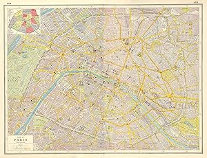
Plan of Paris; Inset map of Arrondissements
Date d'Èdition : 1920
Vendeur : Antiqua Print Gallery, London, Royaume-Uni
…valuation du vendeur 3 sur 5 Ètoiles

Carte
EUR 37,80
Autre deviseEUR 12,61 expÈdition depuis Royaume-Uni vers FranceQuantitÈ disponible : 1 disponible(s)
Ajouter au panierEtat : Good. PARIS WEST. Plan of Paris west sheet; inset Arrondissements 1920 old map. Vintage colour map; Harmsworth (1920). 33.0 x 22.0cm, 13 x 8.5 inches. Condition: Good. The item offered for sale is one page of a map originally published on two adjacent pages - it lacks a full border and may have a tight margin along one edge (see image). There are images and/or text printed on the reverse side of the picture. In some cases this may be visible on the picture itself or around the margin of the picture.
-
Plan of Paris; Inset map of Arrondissements
Date d'Èdition : 1920
Vendeur : Antiqua Print Gallery, London, Royaume-Uni
…valuation du vendeur 3 sur 5 Ètoiles
Carte
EUR 70,87
Autre deviseEUR 12,61 expÈdition depuis Royaume-Uni vers FranceQuantitÈ disponible : 1 disponible(s)
Ajouter au panierEtat : Good. PARIS CITY PLAN. tramways railways fortifications Arrondissements 1920 old map. Vintage colour map; Harmsworth (1920). 34.0 x 45.0cm, 13.25 x 17.5 inches. Condition: Good. This map was originally printed as two separate pages which have been professionally joined to form a single sheet. There is interesting related text and images printed on the reverse side of the picture. The paper is thick, and the verso text does not show through to the front of the map.