Montant total (1 article articles) :
Destination de la commande :

planisphčre colonies établissements français 1870 de pollacchi (3 résultats)
Commentaires
Passer aux résultats principaux de la recherche
Filtres de recherche
Type d'article
- Tous les types de produits
- Livres (Aucun autre résultat ne correspond ŕ ces critčres)
- Magazines & Périodiques (Aucun autre résultat ne correspond ŕ ces critčres)
- Bandes dessinées (Aucun autre résultat ne correspond ŕ ces critčres)
- Partitions de musique (Aucun autre résultat ne correspond ŕ ces critčres)
- Art, Affiches et Gravures (Aucun autre résultat ne correspond ŕ ces critčres)
- Photographies (Aucun autre résultat ne correspond ŕ ces critčres)
- Cartes (3)
- Manuscrits & Papiers anciens (Aucun autre résultat ne correspond ŕ ces critčres)
Etat En savoir plus
- Neuf (Aucun autre résultat ne correspond ŕ ces critčres)
- Comme neuf, Trčs bon ou Bon (Aucun autre résultat ne correspond ŕ ces critčres)
- Assez bon ou satisfaisant (3)
- Moyen ou mauvais (Aucun autre résultat ne correspond ŕ ces critčres)
- Conformément ŕ la description (Aucun autre résultat ne correspond ŕ ces critčres)
Reliure
- Toutes
- Couverture rigide (Aucun autre résultat ne correspond ŕ ces critčres)
- Couverture souple (Aucun autre résultat ne correspond ŕ ces critčres)
Particularités
- Ed. originale (Aucun autre résultat ne correspond ŕ ces critčres)
- Signé (Aucun autre résultat ne correspond ŕ ces critčres)
- Jaquette (Aucun autre résultat ne correspond ŕ ces critčres)
- Avec images (3)
- Sans impressions ŕ la demande (3)
Langue (1)
Prix
- Tous les prix
- Moins de EUR 20 (Aucun autre résultat ne correspond ŕ ces critčres)
- EUR 20 ŕ EUR 45
- Plus de EUR 45 (Aucun autre résultat ne correspond ŕ ces critčres)
Livraison gratuite
- Livraison gratuite ŕ destination de Etats-Unis (Aucun autre résultat ne correspond ŕ ces critčres)
Pays
Evaluation du vendeur
-
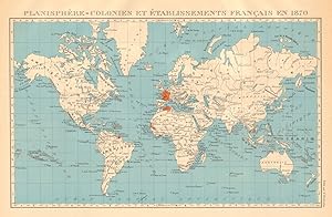
Planisphčre - Colonies et établissements Français en 1870
Date d'édition : 1931
Vendeur : Antiqua Print Gallery, London, Royaume-Uni
Évaluation du vendeur 3 sur 5 étoiles

Carte
EUR 23,59
Autre deviseEUR 11,45 expédition depuis Royaume-Uni vers Etats-UnisQuantité disponible : 2 disponible(s)
Ajouter au panierEtat : Good. FRENCH COLONIES & établissements Français en 1870. Planisphere 1931 old map. Vintage atlas map; Commandant P. Pollacchi (1931). 23.5 x 36.0cm, 9.25 x 14.25 inches. Condition: Good. The image shown may have been taken from a different example of this map than that which is offered for sale. The map you will receive is in good condition but there may be minor variations in the condition from that shown in the image. There is nothing printed on the reverse side, which is plain.
-

Planisphčre - Colonies et établissements Français en 1870
Date d'édition : 1929
Vendeur : Antiqua Print Gallery, London, Royaume-Uni
Évaluation du vendeur 3 sur 5 étoiles
Carte
EUR 24,77
Autre deviseEUR 11,45 expédition depuis Royaume-Uni vers Etats-UnisQuantité disponible : 3 disponible(s)
Ajouter au panierEtat : Good. FRENCH COLONIES & établissements Français en 1870. Planisphere 1929 old map. Vintage atlas map; Commandant P. Pollacchi (1929). 23.5 x 36.0cm, 9.25 x 14.25 inches. Condition: Good. The image shown may have been taken from a different example of this map than that which is offered for sale. The map you will receive is in good condition but there may be minor variations in the condition from that shown in the image. There is nothing printed on the reverse side, which is plain.
-
Planisphere - Colonies et établissements Français en 1870
Date d'édition : 1938
Vendeur : Antiqua Print Gallery, London, Royaume-Uni
Évaluation du vendeur 3 sur 5 étoiles
Carte
EUR 24,77
Autre deviseEUR 11,45 expédition depuis Royaume-Uni vers Etats-UnisQuantité disponible : 1 disponible(s)
Ajouter au panierEtat : Good. FRENCH COLONIES & établissements Français en 1870. Planisphere 1938 old map. Vintage atlas map; Commandant P. Pollacchi (1938). 23.5 x 36.0cm, 9.25 x 14 inches. Condition: Good. The image shown may have been taken from a different example of this map than that which is offered for sale. The map you will receive is in good condition but there may be minor variations in the condition from that shown in the image. There is nothing printed on the reverse side, which is plain.