Montant total (1 article articles) :
Destination de la commande :

rand mcnally cos indexed county de rand mcnally (12 résultats)
Commentaires
Passer aux résultats principaux de la recherche
Filtres de recherche
Type d'article
- Tous les types de produits
- Livres (12)
- Magazines & Périodiques (Aucun autre résultat ne correspond ŕ ces critčres)
- Bandes dessinées (Aucun autre résultat ne correspond ŕ ces critčres)
- Partitions de musique (Aucun autre résultat ne correspond ŕ ces critčres)
- Art, Affiches et Gravures (Aucun autre résultat ne correspond ŕ ces critčres)
- Photographies (Aucun autre résultat ne correspond ŕ ces critčres)
- Cartes (Aucun autre résultat ne correspond ŕ ces critčres)
- Manuscrits & Papiers anciens (Aucun autre résultat ne correspond ŕ ces critčres)
Etat En savoir plus
- Neuf (6)
- Comme neuf, Trčs bon ou Bon (Aucun autre résultat ne correspond ŕ ces critčres)
- Assez bon ou satisfaisant (3)
- Moyen ou mauvais (1)
- Conformément ŕ la description (2)
Particularités
- Ed. originale (3)
- Signé (Aucun autre résultat ne correspond ŕ ces critčres)
- Jaquette (Aucun autre résultat ne correspond ŕ ces critčres)
- Avec images (6)
- Sans impressions ŕ la demande (10)
Langue (2)
Livraison gratuite
Pays
Evaluation du vendeur
-
Rand, McNally and Co's, Indexed Railroad and County Map of Virginia A New and Original Compilation and Index, Designating All Post Office Towns and Railroad Stations Classic Reprint
Vendeur : PBShop.store US, Wood Dale, IL, Etats-Unis
Évaluation du vendeur 5 sur 5 étoiles

EUR 19,41
Autre deviseGratuit expédition vers Etats-UnisQuantité disponible : 15 disponible(s)
Ajouter au panierPAP. Etat : New. New Book. Shipped from UK. Established seller since 2000.
-
Rand, McNally and Co's, Indexed Railroad and County Map of Virginia A New and Original Compilation and Index, Designating All Post Office Towns and Railroad Stations Classic Reprint
Vendeur : PBShop.store UK, Fairford, GLOS, Royaume-Uni
Évaluation du vendeur 5 sur 5 étoiles
EUR 18
Autre deviseEUR 3,76 expédition depuis Royaume-Uni vers Etats-UnisQuantité disponible : 15 disponible(s)
Ajouter au panierPAP. Etat : New. New Book. Shipped from UK. Established seller since 2000.
-

Rand, McNally and Co's, Indexed Railroad and County Map of Virginia A New and Original Compilation and Index, Designating All Post Office Towns and Railroad Stations Classic Reprint
Vendeur : PBShop.store US, Wood Dale, IL, Etats-Unis
Évaluation du vendeur 5 sur 5 étoiles
EUR 24,94
Autre deviseGratuit expédition vers Etats-UnisQuantité disponible : 15 disponible(s)
Ajouter au panierHRD. Etat : New. New Book. Shipped from UK. Established seller since 2000.
-
Rand, McNally and Co's, Indexed Railroad and County Map of Virginia A New and Original Compilation and Index, Designating All Post Office Towns and Railroad Stations Classic Reprint
Vendeur : PBShop.store UK, Fairford, GLOS, Royaume-Uni
Évaluation du vendeur 5 sur 5 étoiles
EUR 22,63
Autre deviseEUR 4,76 expédition depuis Royaume-Uni vers Etats-UnisQuantité disponible : 15 disponible(s)
Ajouter au panierHRD. Etat : New. New Book. Shipped from UK. Established seller since 2000.
-
Rand, McNally and Co's, Indexed Railroad and County Map of Virginia
Vendeur : Forgotten Books, London, Royaume-Uni
Évaluation du vendeur 5 sur 5 étoiles
EUR 15,72
Autre deviseGratuit expédition depuis Royaume-Uni vers Etats-UnisQuantité disponible : Plus de 20 disponibles
Ajouter au panierPaperback. Etat : New. Print on Demand. The book is a collection of maps published in 1883 by Rand McNally and Company, and provides a detailed look at the expansive railroad and county systems of Virginia, with particular focus on the political and economic climates. It includes a detailed index of cities, towns, and other points of interest, as well as information on postal routes. The author provides an informed overview of the period, helping readers understand the context of the maps and the significance of the railroad system to the development of Virginia. By exploring the role of the railroads in shaping the state's economy and society, this book offers a valuable resource for historians, genealogists, and anyone interested in the rich history of Virginia. This book is a reproduction of an important historical work, digitally reconstructed using state-of-the-art technology to preserve the original format. In rare cases, an imperfection in the original, such as a blemish or missing page, may be replicated in the book. print-on-demand item.
-

Rand McNally & Co's Indexed County and Township Map of Illinois
Edité par Rand McNally & Co., Chicago, 1882
Vendeur : James & Mary Laurie, Booksellers A.B.A.A, Minneapolis, MN, Etats-Unis
Membre d'association : ABAA ILAB MWABA
Évaluation du vendeur 2 sur 5 étoiles

EUR 127,18
Autre deviseGratuit expédition vers Etats-UnisQuantité disponible : 1 disponible(s)
Ajouter au panierPaperback. Etat : Very good condition. Bound in publisher's original wrappers stamped in black with yap edges. 94 numbered pp. with color folding map tipped to the inside of the rear cover. Wrappers are seperated. Wear to the extremities. Previous owner's name in ink on the tltle page.
-
Rand, McNally & co's indexed county and township pocket map and shippers' guide of South Dakota.index, showing in detail the entire railroad system . cites, towns, post offices, railroad stations, villages, counties, islands, lakes, rivers, etc.
Edité par Rand McNally and Company., Chicago, 1896
Vendeur : Cambridge Books, Cambridge, MN, Etats-Unis
Évaluation du vendeur 5 sur 5 étoiles
EUR 127,18
Autre deviseEUR 4,24 expédition vers Etats-UnisQuantité disponible : 1 disponible(s)
Ajouter au panierSoft cover. Etat : Good. 1896. 20 pages, 1 map : color ; 32 x 48 cm on sheet 36 x 50 cm folded in text 17 cm. Worn, with some misfolds and dog ears to the map.
-
RAND, McNALLY & CO'S INDEXED COUNTY AND RAILROAD POCKET MAP SHIPPER'S GUIDE INDIAN AND OKLAHOMA TERRITORIES
Edité par Rand McNally, Chicago, 1901, 1901
Vendeur : Archives Books inc., Edmond, OK, Etats-Unis
Évaluation du vendeur 5 sur 5 étoiles
EUR 157,66
Autre deviseEUR 5,57 expédition vers Etats-UnisQuantité disponible : 1 disponible(s)
Ajouter au panierPaperback. Etat : Acceptable. 1906 printing. No markings. Minor wear to cover due to age. No fold-out map. More photos on request. Historic Oklahoma Bookstore on Route 66. Packages shipped daily, Mon-Fri.
-
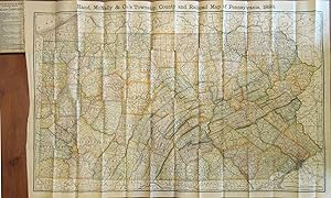
RAND MCNALLY & CO'S INDEXED COUNTY AND RAILROAD POCKET MAP AND SHIPPERS' GUIDE OF PENNSYLVANIA ACCOMPANIED BY.COMPILATION AND READY REFERENCE INDEX SHOWING ENTIRE RAILROAD SYSTEM
Edité par Rand McNally & Co., Chcago; New York, 1888
Vendeur : Nick Bikoff, IOBA, Fairfield, NJ, Etats-Unis
Membre d'association : IOBA
Évaluation du vendeur 5 sur 5 étoiles
Edition originale
EUR 397,44
Autre deviseEUR 3,43 expédition vers Etats-UnisQuantité disponible : 1 disponible(s)
Ajouter au panierHardcover. Etat : Very Good. First Edition. Dark green boards with bright gilt title on front cover. Front endpaper has rand McNally ads: rear endpaper has map mounted onto it. Text is tight, clean & intact. Map measures 39" x 25 1/2" and is in very nice condition except for a few small tears on the folds. Pennsylvania, Map, Railroad. ; Fold out Map; 16mo 6" - 7" tall; 152 pages.
-
Rand, McNally & Co's Indexed County and Township Pocket Map and Shippers' Guide of New Jersey - Showing in Detail the Entire Railroad System, The Express Company Doing Business over Each Road, and Accurately Locating All Cities, Towns, Post Offices, Railr
Edité par Rand McNally & Company, Chicago and New York, 1892
Vendeur : About Books, Henderson, NV, Etats-Unis
Évaluation du vendeur 5 sur 5 étoiles
Edition originale
EUR 613,83
Autre deviseEUR 5,57 expédition vers Etats-UnisQuantité disponible : 1 disponible(s)
Ajouter au panierPaperback. Etat : Very Good+ condition. Chicago and New York: Rand McNally & Company, 1892. Very Good+ condition but for short tears at 3 or 4 of the map folds which have been neatly reinforced with archival tape on the blank side. SEE PHOTOS. A very attractive, well preserved copy. 60 pages of text, including brief information on 78 railroads, a detailed 39-page index, and ads for Rand McNally publications. Attached at the rear is a full color map (that unfolds to 13'' wide by 21" tall). Bound in the publisher's tan-color stiff printed wraps. Cover title: Rand, McNally & Co's Indexed County and Township Pocket Map and Shippers' Guide of New Jersey Showing in Detail the Entire Railroad System, The Express Company Doing Business over Each Road, and Accurately Locating All Cities, Towns, Post Offices, Railroad Stations, Villages, Counties, Islands, Lakes, Rivers, etc Locating the Nearest Mailing Point of All Local Places; Designating Telegraph Stations Population is Given According to the Latest Official Census" [i.e. 1890]. 1st ed? (No additional printings listed). Stiff card covers. Very Good+ condition. 60 pages + a full color, fold-out map. 1st ed? (No additional printings listed).
-
![Image du vendeur pour Rand, McNally & Co's. indexed county map and shippers' guide of Ontario accompanied by a new and original compilation and ready reference index, showing in detail the entire railroad system. 1881 [LeatherBound] mis en vente par True World of Books](https://pictures.abebooks.com/inventory/md/md31533700864.jpg)
Rand, McNally & Co's. indexed county map and shippers' guide of Ontario accompanied by a new and original compilation and ready reference index, showing in detail the entire railroad system. 1881 [LeatherBound]
Date d'édition : 2025
Vendeur : True World of Books, Delhi, Inde
Évaluation du vendeur 5 sur 5 étoiles
EUR 21,19
Autre deviseGratuit expédition depuis Inde vers Etats-UnisQuantité disponible : 18 disponible(s)
Ajouter au panierLeatherBound. Etat : New. BOOKS ARE EXEMPT FROM IMPORT DUTIES AND TARIFFS; NO EXTRA CHARGES APPLY. Leather Binding on Spine and Corners with Golden leaf printing on spine. Bound in genuine leather with Satin ribbon page markers and Spine with raised gilt bands. A perfect gift for your loved ones. Reprinted from 1881 edition. NO changes have been made to the original text. This is NOT a retyped or an ocr'd reprint. Illustrations, Index, if any, are included in black and white. Each page is checked manually before printing. As this print on demand book is reprinted from a very old book, there could be some missing or flawed pages, but we always try to make the book as complete as possible. Fold-outs, if any, are not part of the book. If the original book was published in multiple volumes then this reprint is of only one volume, not the whole set and contains approximately 44 pages. IF YOU WISH TO ORDER PARTICULAR VOLUME OR ALL THE VOLUMES YOU CAN CONTACT US. Resized as per current standards. Sewing binding for longer life, where the book block is actually sewn (smythe sewn/section sewn) with thread before binding which results in a more durable type of binding. Language: English.
-
RAND, MCNALLY & CO'S INDEXED COUNTY AND TOWNSHIP MAP OF DAKOTA WITH A NEW AND ORIGINAL COMPILATION AND INDEX, DESIGNATING ALL POST OFFICE TOWNS AND RAILROAD STATIONS, AND GIVING FULL POSTAL DIRECTIONS FOR SENDING MAIL MATTER TO EVERY PLACE NOT A POST OFFICE, IN THE TERRITORY, KNOWN IN THE POST OFFICE DEPARTMENT AS "LOCALS," ALSO, GIVING AN ALPHABETICALLY ARRANGED LIST OF THE RAILROADS IN THE TERRITORY (WITH THE NAME OF THE EXPRESS COMPANY DOING BUSINESS OVER SUCH), AND OF ALL COUNTIES, LAKES, RIVERS, ETC. ETC. (COVER TITLE)
Edité par Rand, McNally & Co, 1883., Chicago, 1883
Vendeur : BUCKINGHAM BOOKS, ABAA, ILAB, IOBA, GREENCASTLE, PA, Etats-Unis
Membre d'association : ABAA ILAB IOBA RMABA TXBA
Évaluation du vendeur 5 sur 5 étoiles
Edition originale
EUR 662,41
Autre deviseEUR 13,29 expédition vers Etats-UnisQuantité disponible : 1 disponible(s)
Ajouter au panierFirst edition. Large 26 1/2" x 20 1/2 " full-color folding map of Dakota Territory that details all locations of railroads, counties, Indian Reservations, creeks, mountains, buttes and hills, rivers, towns, etc. All locations are indexed with locations for each provided. Tiny tears to a few fold creases else a fine, brightly colored, unused map of 1883 Dakota Territory.