Montant total (1 article articles) :
Destination de la commande :

remote british islands isles guernsey de thomson john (3 résultats)
Commentaires
Passer aux résultats principaux de la recherche
Filtres de recherche
Type d'article
- Tous les types de produits
- Livres (Aucun autre résultat ne correspond ŕ ces critčres)
- Magazines & Périodiques (Aucun autre résultat ne correspond ŕ ces critčres)
- Bandes dessinées (Aucun autre résultat ne correspond ŕ ces critčres)
- Partitions de musique (Aucun autre résultat ne correspond ŕ ces critčres)
- Art, Affiches et Gravures (Aucun autre résultat ne correspond ŕ ces critčres)
- Photographies (Aucun autre résultat ne correspond ŕ ces critčres)
- Cartes (3)
- Manuscrits & Papiers anciens (Aucun autre résultat ne correspond ŕ ces critčres)
Etat En savoir plus
- Neuf (Aucun autre résultat ne correspond ŕ ces critčres)
- Comme neuf, Trčs bon ou Bon (Aucun autre résultat ne correspond ŕ ces critčres)
- Assez bon ou satisfaisant (3)
- Moyen ou mauvais (Aucun autre résultat ne correspond ŕ ces critčres)
- Conformément ŕ la description (Aucun autre résultat ne correspond ŕ ces critčres)
Reliure
- Toutes
- Couverture rigide (Aucun autre résultat ne correspond ŕ ces critčres)
- Couverture souple (Aucun autre résultat ne correspond ŕ ces critčres)
Particularités
- Ed. originale (Aucun autre résultat ne correspond ŕ ces critčres)
- Signé (Aucun autre résultat ne correspond ŕ ces critčres)
- Jaquette (Aucun autre résultat ne correspond ŕ ces critčres)
- Avec images (3)
- Sans impressions ŕ la demande (3)
Langue (1)
Prix
- Tous les prix
- Moins de EUR 20 (Aucun autre résultat ne correspond ŕ ces critčres)
- EUR 20 ŕ EUR 45 (Aucun autre résultat ne correspond ŕ ces critčres)
- Plus de EUR 45
Livraison gratuite
- Livraison gratuite ŕ destination de France (Aucun autre résultat ne correspond ŕ ces critčres)
Pays
Evaluation du vendeur
-
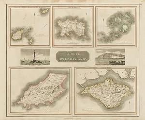
Remote British Islands. Isles of Guernsey, Herm, Sark and Alderney. Isle of Jersey. Isles of Scilly. Isle of Mann. Isle of Wight.
Date d'édition : 1830
Vendeur : Antiqua Print Gallery, London, Royaume-Uni
Évaluation du vendeur 3 sur 5 étoiles

Carte
EUR 100,28
Autre deviseEUR 12,60 expédition depuis Royaume-Uni vers FranceQuantité disponible : 1 disponible(s)
Ajouter au panierEtat : Good. "Remote British Islands" Channel & Scilly Isles of Man & Wight. THOMSON 1830 map. Antique early 19th century atlas map with original hand colouring; Drawn & engraved by Nathaniel Robert Hewitt for John Thomson's "New General Atlas" (1830). 52.5 x 63.0cm, 20.5 x 24.75 inches; this is a folding map. Condition: Good. There is nothing printed on the reverse side, which is plain.
-
Remote British Islands. Isles of Guernsey, Herm, Sark and Alderney. Isle of Jersey. Isles of Scilly. Isle of Mann. Isle of Wight.
Date d'édition : 1817
Vendeur : Antiqua Print Gallery, London, Royaume-Uni
Évaluation du vendeur 3 sur 5 étoiles
Carte
EUR 117,98
Autre deviseEUR 12,60 expédition depuis Royaume-Uni vers FranceQuantité disponible : 1 disponible(s)
Ajouter au panierEtat : Good. "Remote British Islands" Channel & Scilly Isles of Man & Wight. THOMSON 1817 map. Antique early 19th century atlas map with original hand colouring; Drawn & engraved by Nathaniel Robert Hewitt for John Thomson's "New General Atlas" (Published in 1817. Engraved on 1st January 1817; this date is marked on the map). 53.5 x 65.0cm, 21 x 25.5 inches; this is a folding map. Condition: Good. Spotting in top margin. There is nothing printed on the reverse side, which is plain.
-
Remote British Islands. Isles of Guernsey, Herm, Sark and Alderney. Isle of Jersey. Isles of Scilly. Isle of Mann. Isle of Wight.
Date d'édition : 1817
Vendeur : Antiqua Print Gallery, London, Royaume-Uni
Évaluation du vendeur 3 sur 5 étoiles
Carte
EUR 117,98
Autre deviseEUR 12,60 expédition depuis Royaume-Uni vers FranceQuantité disponible : 1 disponible(s)
Ajouter au panierEtat : Good. "Remote British Islands" Channel & Scilly Isles of Wight & Man. THOMSON 1817 map. Antique early 19th century atlas map with original hand colouring; Drawn & engraved by Nathaniel Robert Hewitt for John Thomson's "New General Atlas" (Published in 1817. Engraved on 1st January 1817; this date is marked on the map). 53.5 x 65.0cm, 21 x 25.5 inches; this is a folding map. Condition: Good. There is nothing printed on the reverse side, which is plain.