
Montant total (1 article articles) :
Destination de la commande :

sketch showing progress section de u s coast survey office (114 résultats)
Commentaires
Passer aux résultats principaux de la recherche
Filtres de recherche
Type d'article
- Tous les types de produits
- Livres (114)
- Magazines & Périodiques (Aucun autre résultat ne correspond ŕ ces critčres)
- Bandes dessinées (Aucun autre résultat ne correspond ŕ ces critčres)
- Partitions de musique (Aucun autre résultat ne correspond ŕ ces critčres)
- Art, Affiches et Gravures (Aucun autre résultat ne correspond ŕ ces critčres)
- Photographies (Aucun autre résultat ne correspond ŕ ces critčres)
- Cartes (Aucun autre résultat ne correspond ŕ ces critčres)
- Manuscrits & Papiers anciens (Aucun autre résultat ne correspond ŕ ces critčres)
Etat En savoir plus
- Neuf (Aucun autre résultat ne correspond ŕ ces critčres)
- Comme neuf, Trčs bon ou Bon (Aucun autre résultat ne correspond ŕ ces critčres)
- Assez bon ou satisfaisant (Aucun autre résultat ne correspond ŕ ces critčres)
- Moyen ou mauvais (Aucun autre résultat ne correspond ŕ ces critčres)
- Conformément ŕ la description (114)
Reliure
- Toutes
- Couverture rigide (Aucun autre résultat ne correspond ŕ ces critčres)
- Couverture souple (Aucun autre résultat ne correspond ŕ ces critčres)
Particularités
- Ed. originale (Aucun autre résultat ne correspond ŕ ces critčres)
- Signé (Aucun autre résultat ne correspond ŕ ces critčres)
- Jaquette (Aucun autre résultat ne correspond ŕ ces critčres)
- Avec images (114)
- Sans impressions ŕ la demande (114)
Langue (1)
Livraison gratuite
- Livraison gratuite ŕ destination de France (Aucun autre résultat ne correspond ŕ ces critčres)
Pays
Evaluation du vendeur
-
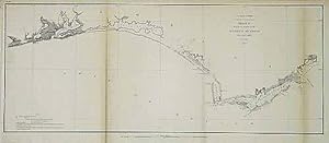
U.S. Coast Survey Sketch G Showing the Progress of the Survey in Section VII (Panhandle)
Date d'édition : 1853
Vendeur : Art Source International Inc., Boulder, CO, Etats-Unis
Évaluation du vendeur 2 sur 5 étoiles

EUR 21,80
Autre deviseEUR 33,86 expédition depuis Etats-Unis vers FranceQuantité disponible : 1 disponible(s)
Ajouter au panierThis black and white, antique coastal survey was made for the United States Coast Survey. The surveys provide depth readings and notes on important coastal characteristics of the area mapped. The names of harbors, rivers, islands, light houses, channels, shoals, capes, inlets, and coastal towns are identified on the map. These charts show areas that have likely undergone significant changes due to modifications and recessions of coastal lands, making them fascinating to anyone interested in local geography and history. Note: Age toning around the folds in these maps is quite common. Map is sold folded as issued. This map measures 23 inches by 9.5 inches.
-

U.S. Coast Survey Sketch H Showing the Progress of the Survey in Section No. VIII
Date d'édition : 1853
Vendeur : Art Source International Inc., Boulder, CO, Etats-Unis
Évaluation du vendeur 2 sur 5 étoiles
EUR 30,51
Autre deviseEUR 33,86 expédition depuis Etats-Unis vers FranceQuantité disponible : 3 disponible(s)
Ajouter au panierThis black and white, antique coastal survey was made for the United States Coast Survey. The surveys provide depth readings and notes on important coastal characteristics of the area mapped. The names of harbors, rivers, islands, channels, shoals, capes, inlets, and coastal towns are identified on the map. These charts show areas that have likely undergone significant changes due to modifications and recessions of coastal lands, making them fascinating to anyone interested in local geography and history. Sold folded as issued. This map measures 33 inches by 19 inches.
-

U.S. Coast Survey Sketch A Showing the Progress of the Survey in Section No. 1
Date d'édition : 1863
Vendeur : Art Source International Inc., Boulder, CO, Etats-Unis
Évaluation du vendeur 2 sur 5 étoiles
EUR 30,51
Autre deviseEUR 33,86 expédition depuis Etats-Unis vers FranceQuantité disponible : 3 disponible(s)
Ajouter au panierThis black and white, antique coastal survey was made for the United States Coast Survey. The surveys provide depth readings and notes on important coastal characteristics of the area mapped. The names of harbors, rivers, islands, channels, shoals, capes, inlets, and coastal towns are identified on the map. These charts show areas that have likely undergone significant changes due to modifications and recessions of coastal lands, making them fascinating to anyone interested in local geography and history. Sold folded as issued. This map measures 27 inches by 17 inches.
-

U.S. Coast Survey Sketch A Showing the Progress of the Survey in Section No. 1
Date d'édition : 1868
Vendeur : Art Source International Inc., Boulder, CO, Etats-Unis
Évaluation du vendeur 2 sur 5 étoiles
EUR 30,51
Autre deviseEUR 33,86 expédition depuis Etats-Unis vers FranceQuantité disponible : 3 disponible(s)
Ajouter au panierThis black and white, antique coastal survey was made for the United States Coast Survey. The surveys provide notes on important coastal characteristics of the area mapped. The names of harbors, rivers, depth readings, and important coastal towns are identified on the map. These charts show areas that have likely undergone significant changes due to modifications and recessions of coastal lands, making them fascinating to anyone interested in local geography and history. This map measures 28 inches by 18 inches.
-

Sketch H Showing the Progress of the Survey in Section No. VIII
Date d'édition : 1860
Vendeur : Art Source International Inc., Boulder, CO, Etats-Unis
Évaluation du vendeur 2 sur 5 étoiles
EUR 30,51
Autre deviseEUR 33,86 expédition depuis Etats-Unis vers FranceQuantité disponible : 3 disponible(s)
Ajouter au panierThis black and white, antique coastal survey was made for the United States Coast Survey. The surveys provide depth readings and notes on important coastal characteristics of the area mapped. The names of harbors, rivers, islands, light houses, channels, shoals, capes, inlets, and coastal towns are identified on the map. These charts show areas that have likely undergone significant changes due to modifications and recessions of coastal lands, making them fascinating to anyone interested in local geography and history. Note: Age toning around the folds in these maps is quite common. Map is sold folded as issued. This map measures 35 inches by 22 inches.
-

U.S. Coast Survey Sketch C Showing the Progress of the Survey in Section No. III
Date d'édition : 1863
Vendeur : Art Source International Inc., Boulder, CO, Etats-Unis
Évaluation du vendeur 2 sur 5 étoiles
EUR 30,51
Autre deviseEUR 33,86 expédition depuis Etats-Unis vers FranceQuantité disponible : 3 disponible(s)
Ajouter au panierThis black and white, antique coastal survey was made for the United States Coast Survey. The surveys provide depth readings and notes on important coastal characteristics of the area mapped. The names of harbors, rivers, islands, channels, shoals, capes, inlets, and coastal towns are identified on the map. These charts show areas that have likely undergone significant changes due to modifications and recessions of coastal lands, making them fascinating to anyone interested in local geography and history. Sold folded as issued. This map measures 22.5 inches by 33.5 inches.
-

U.S. Coast Survey Sketch B Showing the Progress of the Survey in Section No. II
Date d'édition : 1854
Vendeur : Art Source International Inc., Boulder, CO, Etats-Unis
Évaluation du vendeur 2 sur 5 étoiles
EUR 30,51
Autre deviseEUR 33,86 expédition depuis Etats-Unis vers FranceQuantité disponible : 3 disponible(s)
Ajouter au panierThis black and white, antique coastal survey was made for the United States Coast Survey. The surveys provide depth readings and notes on important coastal characteristics of the area mapped. The names of harbors, rivers, islands, channels, shoals, capes, inlets, and coastal towns are identified on the map. These charts show areas that have likely undergone significant changes due to modifications and recessions of coastal lands, making them fascinating to anyone interested in local geography and history. Sold folded as issued. This map measures 18 inches by 16.5 inches.
-

U.S. Coast Survey Sketch H Showing the Progress of the Survey in Section No. VIII
Date d'édition : 1861
Vendeur : Art Source International Inc., Boulder, CO, Etats-Unis
Évaluation du vendeur 2 sur 5 étoiles
EUR 30,51
Autre deviseEUR 33,86 expédition depuis Etats-Unis vers FranceQuantité disponible : 3 disponible(s)
Ajouter au panierThis black and white, antique coastal survey was made for the United States Coast Survey. The surveys provide depth readings and notes on important coastal characteristics of the area mapped. The names of harbors, rivers, islands, channels, shoals, capes, inlets, and coastal towns are identified on the map. These charts show areas that have likely undergone significant changes due to modifications and recessions of coastal lands, making them fascinating to anyone interested in local geography and history. Sold folded as issued. This map measures 33 inches by 19 inches.
-

Sketch C Showing the Progress of the Survey in Section No. III
Date d'édition : 1862
Vendeur : Art Source International Inc., Boulder, CO, Etats-Unis
Évaluation du vendeur 2 sur 5 étoiles
EUR 30,51
Autre deviseEUR 33,86 expédition depuis Etats-Unis vers FranceQuantité disponible : 2 disponible(s)
Ajouter au panierThis black and white, antique coastal survey was made for the United States Coast Survey. The surveys provide depth readings and notes on important coastal characteristics of the area mapped. The names of harbors, rivers, islands, channels, shoals, capes, inlets, and coastal towns maybe identified on this map. These charts show areas that have likely undergone significant changes due to modifications and recessions of coastal lands, making them fascinating to anyone interested in local geography and history. Sold folded as issued. This map measures 22 inches by 33 inches.
-

U.S. Coast Survey Sketch A Showing the Progress of the Survey in Section No. 1
Date d'édition : 1870
Vendeur : Art Source International Inc., Boulder, CO, Etats-Unis
Évaluation du vendeur 2 sur 5 étoiles
EUR 30,51
Autre deviseEUR 33,86 expédition depuis Etats-Unis vers FranceQuantité disponible : 2 disponible(s)
Ajouter au panierThis black and white, antique coastal survey was made for the United States Coast Survey. The surveys provide notes on important coastal characteristics of the area mapped. The names of harbors, rivers, depth readings, and important coastal towns are identified on the map. These charts show areas that have likely undergone significant changes due to modifications and recessions of coastal lands, making them fascinating to anyone interested in local geography and history. This map measures 28 inches by 18 inches.
-

U.S. Coast Survey Sketch E Showing the Progress of the Survey in Section No. V
Date d'édition : 1851
Vendeur : Art Source International Inc., Boulder, CO, Etats-Unis
Évaluation du vendeur 2 sur 5 étoiles
EUR 30,51
Autre deviseEUR 33,86 expédition depuis Etats-Unis vers FranceQuantité disponible : 2 disponible(s)
Ajouter au panierThis black and white, antique coastal survey was made for the United States Coast Survey. The surveys provide depth readings and notes on important coastal characteristics of the area mapped. The names of harbors, rivers, islands, channels, shoals, capes, inlets, and coastal towns are identified on the map. These charts show areas that have likely undergone significant changes due to modifications and recessions of coastal lands, making them fascinating to anyone interested in local geography and history. Sold folded as issued. This map measures 10.5 inches by 11 inches.
-

U.S. Coast Survey Sketch A Showing the Progress of the Survey in Section No. 1
Date d'édition : 1875
Vendeur : Art Source International Inc., Boulder, CO, Etats-Unis
Évaluation du vendeur 2 sur 5 étoiles
EUR 30,51
Autre deviseEUR 33,86 expédition depuis Etats-Unis vers FranceQuantité disponible : 1 disponible(s)
Ajouter au panierThis black and white, antique coastal survey was made for the United States Coast Survey. The surveys provide notes on important coastal characteristics of the area mapped. The names of harbors, rivers, depth readings, and important coastal towns are identified on the map. These charts show areas that have likely undergone significant changes due to modifications and recessions of coastal lands, making them fascinating to anyone interested in local geography and history. This map measures 28 inches by 17.5 inches.
-

U.S. Coast Survey Sketch A Showing the Progress of the Survey in Section No. 1
Date d'édition : 1877
Vendeur : Art Source International Inc., Boulder, CO, Etats-Unis
Évaluation du vendeur 2 sur 5 étoiles
EUR 30,51
Autre deviseEUR 33,86 expédition depuis Etats-Unis vers FranceQuantité disponible : 1 disponible(s)
Ajouter au panierThis black and white, antique coastal survey was made for the United States Coast Survey. The surveys provide notes on important coastal characteristics of the area mapped. The names of harbors, rivers, depth readings, and important coastal towns are identified on the map. These charts show areas that have likely undergone significant changes due to modifications and recessions of coastal lands, making them fascinating to anyone interested in local geography and history. This map measures 28 inches by 18 inches.
-

Sketch B. Showing the Progress of Section No. 2
Date d'édition : 1852
Vendeur : Art Source International Inc., Boulder, CO, Etats-Unis
Évaluation du vendeur 2 sur 5 étoiles
EUR 34,87
Autre deviseEUR 33,86 expédition depuis Etats-Unis vers FranceQuantité disponible : 3 disponible(s)
Ajouter au panierThis black and white, antique coastal survey was made for the United States Coast Survey. The surveys provide depth readings and notes on important coastal characteristics of the area mapped. The names of harbors, rivers, islands, channels, shoals, capes, inlets, and coastal towns are identified on the map. These charts show areas that have likely undergone significant changes due to modifications and recessions of coastal lands, making them fascinating to anyone interested in local geography and history. Sold folded as issued. This map measures 24 inches by 22 inches.
-

Sketch J Showing the Progress of the Survey in Section No. X - Middle Sheet - From Pt. Sal to Tomales Bay - 1873
Date d'édition : 1873
Vendeur : Art Source International Inc., Boulder, CO, Etats-Unis
Évaluation du vendeur 2 sur 5 étoiles
EUR 34,87
Autre deviseEUR 33,86 expédition depuis Etats-Unis vers FranceQuantité disponible : 3 disponible(s)
Ajouter au panierThis black and white, antique coastal survey was made for the United States Coast Survey. The surveys provide depth readings and notes on important coastal characteristics of the area mapped. The names of harbors, rivers, islands, light houses, channels, shoals, capes, inlets, and coastal towns are identified on the map. These charts show areas that have likely undergone significant changes due to modifications and recessions of coastal lands, making them fascinating to anyone interested in local geography and history. Note: Age toning around the folds in these maps is quite common. Map is sold folded as issued. This map measures 21 inches by 31 inches.
-

Sketch Showing the Progress of the Survey in Section No. X - Middle Sheet - From Pt. Sal to Tomales Bay - 1881
Date d'édition : 1881
Vendeur : Art Source International Inc., Boulder, CO, Etats-Unis
Évaluation du vendeur 2 sur 5 étoiles
EUR 34,87
Autre deviseEUR 33,86 expédition depuis Etats-Unis vers FranceQuantité disponible : 3 disponible(s)
Ajouter au panierThis black and white, antique coastal survey was made for the United States Coast Survey. The surveys provide depth readings and notes on important coastal characteristics of the area mapped. The names of harbors, rivers, islands, light houses, channels, shoals, capes, inlets, and coastal towns are identified on the map. These charts show areas that have likely undergone significant changes due to modifications and recessions of coastal lands, making them fascinating to anyone interested in local geography and history. Note: Age toning around the folds in these maps is quite common. Map is sold folded as issued. This map measures 28 inches by 33.5 inches.
-

Sketch Showing the Progress of the Survey in Section No. X - Lower Sheet - From San Diego to Pt. Sal - 1881
Date d'édition : 1881
Vendeur : Art Source International Inc., Boulder, CO, Etats-Unis
Évaluation du vendeur 2 sur 5 étoiles
EUR 34,87
Autre deviseEUR 33,86 expédition depuis Etats-Unis vers FranceQuantité disponible : 2 disponible(s)
Ajouter au panierThis black and white, antique coastal survey was made for the United States Coast Survey. The surveys provide depth readings and notes on important coastal characteristics of the area mapped. The names of harbors, rivers, islands, light houses, channels, shoals, capes, inlets, and coastal towns are identified on the map. These charts show areas that have likely undergone significant changes due to modifications and recessions of coastal lands, making them fascinating to anyone interested in local geography and history. Note: Age toning around the folds in these maps is quite common. Map is sold folded as issued. This map measures 22 inches by 32 inches.
-

Sketch Showing the Progress of the Survey in Section No. X - Middle Sheet - From Pt. Sal to Tomales Bay - 1877
Date d'édition : 1877
Vendeur : Art Source International Inc., Boulder, CO, Etats-Unis
Évaluation du vendeur 2 sur 5 étoiles
EUR 34,87
Autre deviseEUR 33,86 expédition depuis Etats-Unis vers FranceQuantité disponible : 2 disponible(s)
Ajouter au panierThis black and white, antique coastal survey was made for the United States Coast Survey. The surveys provide depth readings and notes on important coastal characteristics of the area mapped. The names of harbors, rivers, islands, light houses, channels, shoals, capes, inlets, and coastal towns are identified on the map. These charts show areas that have likely undergone significant changes due to modifications and recessions of coastal lands, making them fascinating to anyone interested in local geography and history. Note: Age toning around the folds in these maps is quite common. Map is sold folded as issued. This map measures 22.5 inches by 31.5 inches.
-

Sketch Showing the Progress of the Survey in Section No. X - Middle Sheet - From Pt. Sal to Tomales Bay - 1879
Date d'édition : 1879
Vendeur : Art Source International Inc., Boulder, CO, Etats-Unis
Évaluation du vendeur 2 sur 5 étoiles
EUR 34,87
Autre deviseEUR 33,86 expédition depuis Etats-Unis vers FranceQuantité disponible : 2 disponible(s)
Ajouter au panierThis black and white, antique coastal survey was made for the United States Coast Survey. The surveys provide depth readings and notes on important coastal characteristics of the area mapped. The names of harbors, rivers, islands, light houses, channels, shoals, capes, inlets, and coastal towns are identified on the map. These charts show areas that have likely undergone significant changes due to modifications and recessions of coastal lands, making them fascinating to anyone interested in local geography and history. Note: Age toning around the folds in these maps is quite common. Map is sold folded as issued. This map measures 28.5 inches by 33.5 inches.
-

U.S. Coast Survey Sketch A Showing the Progress of the Survey in Section No. 1
Date d'édition : 1861
Vendeur : Art Source International Inc., Boulder, CO, Etats-Unis
Évaluation du vendeur 2 sur 5 étoiles
EUR 34,87
Autre deviseEUR 33,86 expédition depuis Etats-Unis vers FranceQuantité disponible : 2 disponible(s)
Ajouter au panierThis black and white, antique coastal survey was made for the United States Coast Survey. The surveys provide notes on important coastal characteristics of the area mapped. The names of harbors, rivers, depth readings, and important coastal towns are identified on the map. These charts show areas that have likely undergone significant changes due to modifications and recessions of coastal lands, making them fascinating to anyone interested in local geography and history. This map measures 28 inches by 18 inches.
-

Sketch Showing the Progress of the Survey in Section No. X - Lower Sheet - From San Diego to Pt. Sal - 1879
Date d'édition : 1879
Vendeur : Art Source International Inc., Boulder, CO, Etats-Unis
Évaluation du vendeur 2 sur 5 étoiles
EUR 34,87
Autre deviseEUR 33,86 expédition depuis Etats-Unis vers FranceQuantité disponible : 1 disponible(s)
Ajouter au panierThis black and white, antique coastal survey was made for the United States Coast Survey. The surveys provide depth readings and notes on important coastal characteristics of the area mapped. The names of harbors, rivers, islands, light houses, channels, shoals, capes, inlets, and coastal towns are identified on the map. These charts show areas that have likely undergone significant changes due to modifications and recessions of coastal lands, making them fascinating to anyone interested in local geography and history. Note: Age toning around the folds in these maps is quite common. Map is sold folded as issued. This map measures 22.5 inches by 32.5 inches.
-

Sketch Showing the Progress of the Survey in Section No. X - Middle Sheet - From Pt. Sal to Tomales Bay - 1886
Date d'édition : 1886
Vendeur : Art Source International Inc., Boulder, CO, Etats-Unis
Évaluation du vendeur 2 sur 5 étoiles
EUR 34,87
Autre deviseEUR 33,86 expédition depuis Etats-Unis vers FranceQuantité disponible : 1 disponible(s)
Ajouter au panierThis black and white, antique coastal survey was made for the United States Coast Survey. The surveys provide depth readings and notes on important coastal characteristics of the area mapped. The names of harbors, rivers, islands, light houses, channels, shoals, capes, inlets, and coastal towns are identified on the map. These charts show areas that have likely undergone significant changes due to modifications and recessions of coastal lands, making them fascinating to anyone interested in local geography and history. Note: Age toning around the folds in these maps is quite common. Map is sold folded as issued. This map measures 23.5 inches by 33 inches.
-

Sketch H Showing the Progress of the Survey in Section No. VIII
Date d'édition : 1870
Vendeur : Art Source International Inc., Boulder, CO, Etats-Unis
Évaluation du vendeur 2 sur 5 étoiles
EUR 34,87
Autre deviseEUR 33,86 expédition depuis Etats-Unis vers FranceQuantité disponible : 1 disponible(s)
Ajouter au panierThis black and white, antique coastal survey was made for the United States Coast Survey. The surveys provide depth readings and notes on important coastal characteristics of the area mapped. The names of harbors, rivers, islands, light houses, channels, shoals, capes, inlets, and coastal towns are identified on the map. These charts show areas that have likely undergone significant changes due to modifications and recessions of coastal lands, making them fascinating to anyone interested in local geography and history. Note: Age toning around the folds in these maps is quite common. Map is sold folded as issued. This map measures 34 inches by 23 inches.
-

(Upper Sheet) U.S. Coast Survey - Sketch A Showing the Progress of the Survey in Section No. I - 1862
Date d'édition : 1862
Vendeur : Art Source International Inc., Boulder, CO, Etats-Unis
Évaluation du vendeur 2 sur 5 étoiles
EUR 34,87
Autre deviseEUR 33,86 expédition depuis Etats-Unis vers FranceQuantité disponible : 1 disponible(s)
Ajouter au panierThis black and white, antique coastal survey was made for the United States Coast Survey. The surveys provide depth readings and notes on important coastal characteristics of the area mapped. The names of harbors, rivers, islands, light houses, channels, shoals, capes, inlets, and coastal towns are identified on the map. These charts show areas that have likely undergone significant changes due to modifications and recessions of coastal lands, making them fascinating to anyone interested in local geography and history. Note: Age toning around the folds in these maps is quite common. Map is sold folded as issued. This map measures 30.5 inches by 19.5 inches.
-

Sketch Showing the Progress of the Survey in Section No. VIII
Date d'édition : 1881
Vendeur : Art Source International Inc., Boulder, CO, Etats-Unis
Évaluation du vendeur 2 sur 5 étoiles
EUR 34,87
Autre deviseEUR 33,86 expédition depuis Etats-Unis vers FranceQuantité disponible : 1 disponible(s)
Ajouter au panierThis black and white, antique coastal survey was made for the United States Coast Survey. The surveys provide depth readings and notes on important coastal characteristics of the area mapped. The names of harbors, rivers, islands, light houses, channels, shoals, capes, inlets, and coastal towns are identified on the map. These charts show areas that have likely undergone significant changes due to modifications and recessions of coastal lands, making them fascinating to anyone interested in local geography and history. Note: Age toning around the folds in these maps is quite common. Map is sold folded as issued. This map measures 35 inches by 21.5 inches.
-

Sketch Showing the Progress of the Survey in Section No. VIII
Date d'édition : 1879
Vendeur : Art Source International Inc., Boulder, CO, Etats-Unis
Évaluation du vendeur 2 sur 5 étoiles
EUR 34,87
Autre deviseEUR 33,86 expédition depuis Etats-Unis vers FranceQuantité disponible : 1 disponible(s)
Ajouter au panierThis black and white, antique coastal survey was made for the United States Coast Survey. The surveys provide depth readings and notes on important coastal characteristics of the area mapped. The names of harbors, rivers, islands, light houses, channels, shoals, capes, inlets, and coastal towns are identified on the map. These charts show areas that have likely undergone significant changes due to modifications and recessions of coastal lands, making them fascinating to anyone interested in local geography and history. Note: Age toning around the folds in these maps is quite common. Map is sold folded as issued. This map measures 35.5 inches by 21.5 inches.
-

Sketch Showing the Progress of the Survey in Section No. X - Lower Sheet - From San Diego to Pt. Sal - 1877
Date d'édition : 1877
Vendeur : Art Source International Inc., Boulder, CO, Etats-Unis
Évaluation du vendeur 2 sur 5 étoiles
EUR 34,87
Autre deviseEUR 33,86 expédition depuis Etats-Unis vers FranceQuantité disponible : 1 disponible(s)
Ajouter au panierThis black and white, antique coastal survey was made for the United States Coast Survey. The surveys provide depth readings and notes on important coastal characteristics of the area mapped. The names of harbors, rivers, islands, light houses, channels, shoals, capes, inlets, and coastal towns are identified on the map. These charts show areas that have likely undergone significant changes due to modifications and recessions of coastal lands, making them fascinating to anyone interested in local geography and history. Note: Age toning around the folds in these maps is quite common. Map is sold folded as issued. This map measures 22.5 inches by 31 inches.
-

Sketch H Showing the Progress of the Survey in Section No. VIII
Date d'édition : 1875
Vendeur : Art Source International Inc., Boulder, CO, Etats-Unis
Évaluation du vendeur 2 sur 5 étoiles
EUR 34,87
Autre deviseEUR 33,86 expédition depuis Etats-Unis vers FranceQuantité disponible : 1 disponible(s)
Ajouter au panierThis black and white, antique coastal survey was made for the United States Coast Survey. The surveys provide depth readings and notes on important coastal characteristics of the area mapped. The names of harbors, rivers, islands, light houses, channels, shoals, capes, inlets, and coastal towns are identified on the map. These charts show areas that have likely undergone significant changes due to modifications and recessions of coastal lands, making them fascinating to anyone interested in local geography and history. Note: Age toning around the folds in these maps is quite common. Map is sold folded as issued. This map measures 34.5 inches by 22 inches.
-

Sketch Showing the Progress of the Survey in Section No. X - Middle Sheet - From Pt. Sal to Tomales Bay - 1883
Date d'édition : 1883
Vendeur : Art Source International Inc., Boulder, CO, Etats-Unis
Évaluation du vendeur 2 sur 5 étoiles
EUR 34,87
Autre deviseEUR 33,86 expédition depuis Etats-Unis vers FranceQuantité disponible : 1 disponible(s)
Ajouter au panierThis black and white, antique coastal survey was made for the United States Coast Survey. The surveys provide depth readings and notes on important coastal characteristics of the area mapped. The names of harbors, rivers, islands, light houses, channels, shoals, capes, inlets, and coastal towns are identified on the map. These charts show areas that have likely undergone significant changes due to modifications and recessions of coastal lands, making them fascinating to anyone interested in local geography and history. Note: Age toning around the folds in these maps is quite common. Map is sold folded as issued. This map measures 24 inches by 32.5 inches.
-

U.S. Coast Survey Sketch C Showing the Progress of the Survey in Section No. III
Date d'édition : 1854
Vendeur : Art Source International Inc., Boulder, CO, Etats-Unis
Évaluation du vendeur 2 sur 5 étoiles
EUR 39,23
Autre deviseEUR 33,86 expédition depuis Etats-Unis vers FranceQuantité disponible : 3 disponible(s)
Ajouter au panierThis black and white, antique coastal survey was made for the United States Coast Survey. The surveys provide depth readings and notes on important coastal characteristics of the area mapped. The names of harbors, rivers, islands, channels, shoals, capes, inlets, and coastal towns are identified on the map. These charts show areas that have likely undergone significant changes due to modifications and recessions of coastal lands, making them fascinating to anyone interested in local geography and history. Sold folded as issued. This map measures 22 inches by 34 inches.