Montant total (1 article articles) :
Destination de la commande :

universalior cogniti orbis tabula recentibus de ruysch johannes (3 résultats)
Commentaires
Passer aux résultats principaux de la recherche
Filtres de recherche
Type d'article
- Tous les types de produits
- Livres (Aucun autre résultat ne correspond ŕ ces critčres)
- Magazines & Périodiques (Aucun autre résultat ne correspond ŕ ces critčres)
- Bandes dessinées (Aucun autre résultat ne correspond ŕ ces critčres)
- Partitions de musique (Aucun autre résultat ne correspond ŕ ces critčres)
- Art, Affiches et Gravures (Aucun autre résultat ne correspond ŕ ces critčres)
- Photographies (Aucun autre résultat ne correspond ŕ ces critčres)
- Cartes (3)
- Manuscrits & Papiers anciens (Aucun autre résultat ne correspond ŕ ces critčres)
Etat En savoir plus
- Neuf (Aucun autre résultat ne correspond ŕ ces critčres)
- Comme neuf, Trčs bon ou Bon (Aucun autre résultat ne correspond ŕ ces critčres)
- Assez bon ou satisfaisant (3)
- Moyen ou mauvais (Aucun autre résultat ne correspond ŕ ces critčres)
- Conformément ŕ la description (Aucun autre résultat ne correspond ŕ ces critčres)
Reliure
- Toutes
- Couverture rigide (Aucun autre résultat ne correspond ŕ ces critčres)
- Couverture souple (Aucun autre résultat ne correspond ŕ ces critčres)
Particularités
- Ed. originale (3)
- Signé (Aucun autre résultat ne correspond ŕ ces critčres)
- Jaquette (Aucun autre résultat ne correspond ŕ ces critčres)
- Avec images (3)
- Sans impressions ŕ la demande (3)
Langue (1)
Prix
- Tous les prix
- Moins de EUR 20 (Aucun autre résultat ne correspond ŕ ces critčres)
- EUR 20 ŕ EUR 45 (Aucun autre résultat ne correspond ŕ ces critčres)
- Plus de EUR 45
Livraison gratuite
Pays
Evaluation du vendeur
-
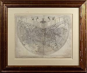
Universalior cogniti orbis tabula ex recentibus confecta observationibus
Edité par Bernardinus Venetus de Vitalibus, Rome, 1508
Vendeur : Arader Books, New York, NY, Etats-Unis
Évaluation du vendeur 5 sur 5 étoiles

Carte Edition originale
EUR 531 359,49
Autre deviseGratuit expédition vers Etats-UnisQuantité disponible : 1 disponible(s)
Ajouter au panierNo binding. Etat : Very good. First. THE EARLIEST OBTAINABLE DEPICTION OF THE NEW WORLD [Rome: Bernardinus Venetus de Vitalibus, 1508.] First edition, Shirley state 5/McGuirk 3-C. Two sheets joined (sheet: 17 1/16" x 22 3/4", 433mm x 578mm; framed: 30" x 35 1/2". Engraved conical-projection map. Float-matted with a window verso, demonstrating the water-mark of the left-hand sheet (a crossbow within a circle). The edges uneven (untrimmed, i.e., deckled?) with some small areas of infill, not touching the image. Rubbing along the sheets' join, with some filled losses at the head and tail, not touching the image. A little soiled at the peripheries, including a faint ink-splatter at lower-left. As exploration pushed European knowledge of the world east and south, cartographers built on the framework of Ptolemy (Claudius Ptolemaeus), a second-century philosopher living in Roman Alexandria in Egypt. In the Greek tradition (Ptolemy wrote in Greek, which was the administrative language of the Roman Empire in the Eastern Mediterranean), philosophy -- the love of wisdom -- bridged what we now divide into the humanities and the sciences; he was a mathematician, natural scientist and geographer-astronomer. No manuscripts of the ?????????? ???????? (Geographical Guidance) survive from before the XIIIc, but some XIIIc examples survive with maps that bear some relation to those Ptolemy himself drew. Thus, with the exception of some excavated carved maps, Ptolemy is the source for ancient cartography as well as its culmination. The discovery of the New World in the late XVc -- Columbus assumed he had found the East Indies because of Ptolemy's calculations and assertions about longitude -- provoked a crisis in the understanding of the disposition of the globe; the Ptolemaic skeleton was showing signs of fracture. It is against this background that Johannes Ruysch (Johan(n) Ruijsch, ca. 1460-1533) made his coniform (cone or fan-shaped) projection. Ruysch was a profoundly cosmopolitan figure; he was Flemish or German or Netherlandish by birth, lived in Cologne, Rome, England and finally Portugal. From England, it is claimed, he himself sailed west as far as the American coast; thus he is the first mapmaker to have traveled to America. Due, perhaps, to his first-hand knowledge of the contradictions entailed by a New World adjoining Ptolemy's, Ruysch was visionary in his solutions. (The title translates to "a more universal illustration of the known world made out of new observations;" the comparative makes clear Ruysch's competitiveness.) Newfoundland adjoins Tibet. Japan (Zipangu) is identified with Spagnola (modern Haiti and the Dominican Republic), although Ruysch is fairly agnostic in his reasoning. In other ways, however, his map is cutting-edge in its modelling of Asia --here the triangular form of India appears for the first time -- and the Caribbean, largely drawing on Portuguese sources. The map's date is sometimes given as 1507, and indeed it does appear in some examples of the 1507 Rome edition of Ptolemy (colophon 8 September 1507); the vast majority, however, appear in 1508 editions, which have the addition of a commentary of Marcus of Benevento (Marcus Beneventanus) based on the findings depicted in this map. The tacit suggestion of most bibliographies is that the map was not completed until very late 1507 or early 1508, and its inclusion in 1507 editions is the work of owners rather than the publisher. Although the 1506 map of Contarini/Rosselli and the 1507 Waldseemüller are earlier (excluding manuscript maps), each survives in a single example. The Ruysch map is thus the earliest obtainable depiction of the New World. McGuirk's 1989 census counted 64 examples, of which 14 were in private collections (plus one on the market in 1986). He also determines that about two-thirds of the maps examined were Shirley's state 5 (his 3-C). McGuirk estimates that 100 examples of the map survive, of which perhaps 25 are in private hands. The present example was acquired from the Clements Library at the University of Michigan. McGuirk, Donald L. "Ruysch World Map: Census and Commentary." Imago Mundi 41 (1989) 133-141. Peerlings, R.H.J., F. Laurentius and J. van den Bovenkamp. "The Watermarks in the Rome Editions of Ptolemy's Cosmography and More." Quaerendo 47 (2017) 307-327. Burden 3 (p. xxiii); Harrisse 56; Sabin 66476 (Ptolemy); Shirley 25.
-

Universalior Cogniti Orbis Tabula Ex Recentibus Confecta Obsevationibus
Edité par Rome, 1507
Vendeur : Clive A. Burden Ltd., Chalfont St. Giles, BUCKS, Royaume-Uni
Membre d'association : ABA ILAB
Évaluation du vendeur 2 sur 5 étoiles

Carte Edition originale
EUR 321 368,78
Autre deviseEUR 25,36 expédition depuis Royaume-Uni vers Etats-UnisQuantité disponible : 1 disponible(s)
Ajouter au panierNo binding. Etat : Very Good. 410 x 550 mm., in two sheets joined as issued, with two tears in the right side lower margin, both about 9 cms., professionally repaired, otherwise in good condition with margins all round. STATE 1-B, ONE OF ONLY THREE EXAMPLES THAT MCGUIRK RECORDS. HE ONLY CITES THREE OF STATE 1-A. AN EXTENSIVE EXAMINATION OF RECORDS SHOWS THAT NO OTHER EARLY STATE HAS APPEARED ON THE MARKET SINCE 1986. THE 'FIRST PUBLISHED MAP MADE BY AN ACTUAL EXPLORER OF THE NEW WORLD' and the FIRST AVAILABLE MAP TO ILLUSTRATE AMERICA. This is only pre-dated by a handful of manuscript portolan maps and the printed map by Giovanni Matteo Contarini and Francesco Rosselli of 1506, of which only one example survives (British Library). Martin Waldseemuller's legendary wall map of 1507 at the Library of Congress might also pre-date it.This map by Johannes Ruysch uses the same fan-shaped conical projection as the Contariniâ"Rosselli. However, where the former draws on a largely Ptolemaic format, Ruysch incorporates extensive current knowledge drawn from Portuguese, Spanish and English sources. Some of this it appears 'is the first-hand knowledge of Ruysch himself who, it is said in the commentary that accompanies the map in the following edition of 1508, 'has navigated from the southern part of England to 53o north latitude, and that he has sailed on the latter parallel as far as the eastern coasts [of America]' (Burden). Thus, it may be said that this is the FIRST PRINTED MAP OF AMERICA BY SOMEONE WITH FIRST HAND KNOWLEDGE. Johannes Ruysch (c.1470-1533) is thought to have accompanied Sebastian Cabot on his 1497 voyage to Newfoundland. He was born in Utrecht, Netherlands, and after his travels he lived in Germany and then Italy. He became a lay priest and settled in Rome. He was an accomplished astronomer and cosmographer. With the patronage of Pope Julius II, Ruysch is believed to have assisted Raphael in painting the 'Astronomia' and other frescoes in the Stanza della segnatura in the Vatican (1509-10). A new edition of the 1490 Rome 'Geographia' by Ptolemy was planned for 1507. It was revised and edited by Marcus Beneventanus and Joannes Cota of Verona. The printer was Bernardinus Venetus de Vitalibus and publisher Evangelista Tosinus, a French publisher who had settled in Rome. For this, six new modern maps were published. The world map was intended to be a seventh but was not ready in time. Thacher wrote that 'There is no map of the New World found in the examples bearing the date of 1507 on the title. That it was intended that there should be such a map is evident from the permission or exclusive permit to sell granted to the publisher Tosinus by Pope Julius II, and which permission is granted as a recompense for the expense Tosinus was under in securing a map of the new regions. This permission is dated July 28, 1506 ⦠In the Rome printing office, the map was not yet ready when the first copies were printed. Shortly after, with the title page simply bearing the date 1508, but with the colophon still dated September 8, 1507, copies were issued announcing that Marcus Beneventanus had prepared a description of the New World and of the ocean pathway from Lisbon to the Indian Ocean, and that accompanying the description was a map of the entire world by Johannes Ruysch, a German'. In the text Beneventanus described Ruysch as 'an exact and painstaking geographer'.We do now know that the map does appear in a very few examples, clearly late issues, of the 1507 edition. The delay was undoubtedly due to the efforts made to make it accurate for there are several corrections made to the plates both before and after first printing. Donald McGuirk studied these various states in the 1980s which were complicated by the fact that each half was printed from a different copper plate. Earlier carto-bibliographers recorded 5 states but as each plate exists in 3 states, a possible total of 9 versions exist. McGuirk's census of 47 maps in institutions and 17 maps in private.
-
Universalior cogniti orbis tabula ex recentibus confecta observationibus
Edité par Bernardinus Venetus de Vitalibus, Rome, 1508
Vendeur : Arader Books, New York, NY, Etats-Unis
Évaluation du vendeur 5 sur 5 étoiles
Carte Edition originale
EUR 448 190,18
Autre deviseGratuit expédition vers Etats-UnisQuantité disponible : 1 disponible(s)
Ajouter au panierNo binding. Etat : Very good. First. THE EARLIEST OBTAINABLE DEPICTION OF THE NEW WORLD. [Rome: Bernardinus Venetus de Vitalibus, 1508.] First edition, Shirley state 5/McGuirk 3-C. Two sheets joined (sheet: 17 7/16" x 22 3/4", 443mm x 578mm; framed: 35 9/16" x 30"). Engraved conical-projection map. Float-matted with a window verso, demonstrating water-marks (crossed arrows). Trimmed at the edges, with about an inch added and loss supplied in facsimile. Some losses at the join, filled in facsimile. A little toning in patches. As exploration pushed European knowledge of the world east and south, cartographers built on the framework of Ptolemy (Claudius Ptolemaeus), a second-century philosopher living in Roman Alexandria in Egypt. In the Greek tradition (Ptolemy wrote in Greek, which was the administrative language of the Roman Empire in the Eastern Mediterranean), philosophy -- the love of wisdom -- bridged what we now divide into the humanities and the sciences; he was a mathematician, natural scientist and geographer-astronomer. No manuscripts of the ?????????? ???????? (Geographical Guidance) survive from before the XIIIc, but some XIIIc examples survive with maps that bear some relation to those Ptolemy himself drew. Thus, with the exception of some excavated carved maps, Ptolemy is the source for ancient cartography as well as its culmination. The discovery of the New World in the late XVc -- Columbus assumed he had found the East Indies because of Ptolemy's calculations and assertions about longitude -- provoked a crisis in the understanding of the disposition of the globe; the Ptolemeian skeleton was showing signs of fracture. It is against this background that Johannes Ruysch (Johan(n) Ruijsch, ca. 1460-1533) made his coniform (cone or fan-shaped) projection. Ruysch was a profoundly cosmopolitan figure; he was Flemish or German or Netherlandish by birth, lived in Cologne, Rome, England and finally Portugal. From England, it is claimed, he himself sailed west as far as the American coast; thus he is the first mapmaker to have traveled to America. Due, perhaps, to his first-hand knowledge of the contradictions entailed by a New World adjoining Ptolemy's, Ruysch was visionary in his solutions. (The title translates to "a more universal illustration of the known world made out of new observations;" the comparative makes clear Ruysch's competitiveness.) Newfoundland adjoins Tibet. Japan (Zipangu) is identified with Spagnola (modern Haiti and the Dominican Republic), although Ruysch is fairly agnostic in his reasoning. In other ways, however, his map is cutting-edge in its modelling of Asia --here the triangular form of India appears for the first time -- and the Caribbean, largely drawing on Portuguese sources. The map's date is sometimes given as 1507, and indeed it does appear in some examples of the 1507 Rome edition of Ptolemy (colophon 8 September 1507); the vast majority, however, appear in 1508 editions, which have the addition of a commentary of Marcus of Benevento (Marcus Beneventanus) based on the findings depicted in this map. The tacit suggestion of most bibliographies is that the map was not completed until very late 1507 or early 1508, and its inclusion in 1507 editions is the work of owners rather than the publisher. Although the 1506 map of Contarini/Rosselli and the 1507 Waldseemüller are earlier (excluding manuscript maps), each survives in a single example. The Ruysch map is thus the earliest obtainable depiction of the New World. McGuirk's 1989 census counted 64 examples, of which 14 were in private collections (plus one on the market in 1986). The present example was purchased from a private collector in 2008. McGuirk, Donald L. "Ruysch World Map: Census and Commentary." Imago Mundi 41 (1989) 133-141. Peerlings, R.H.J., F. Laurentius and J. van den Bovenkamp. "The Watermarks in the Rome Editions of Ptolemy's Cosmography and More." Quaerendo 47 (2017) 307-327. Burden 3 (p. xxiii); Harrisse 56; Sabin 66476 (Ptolemy); Shirley 25.