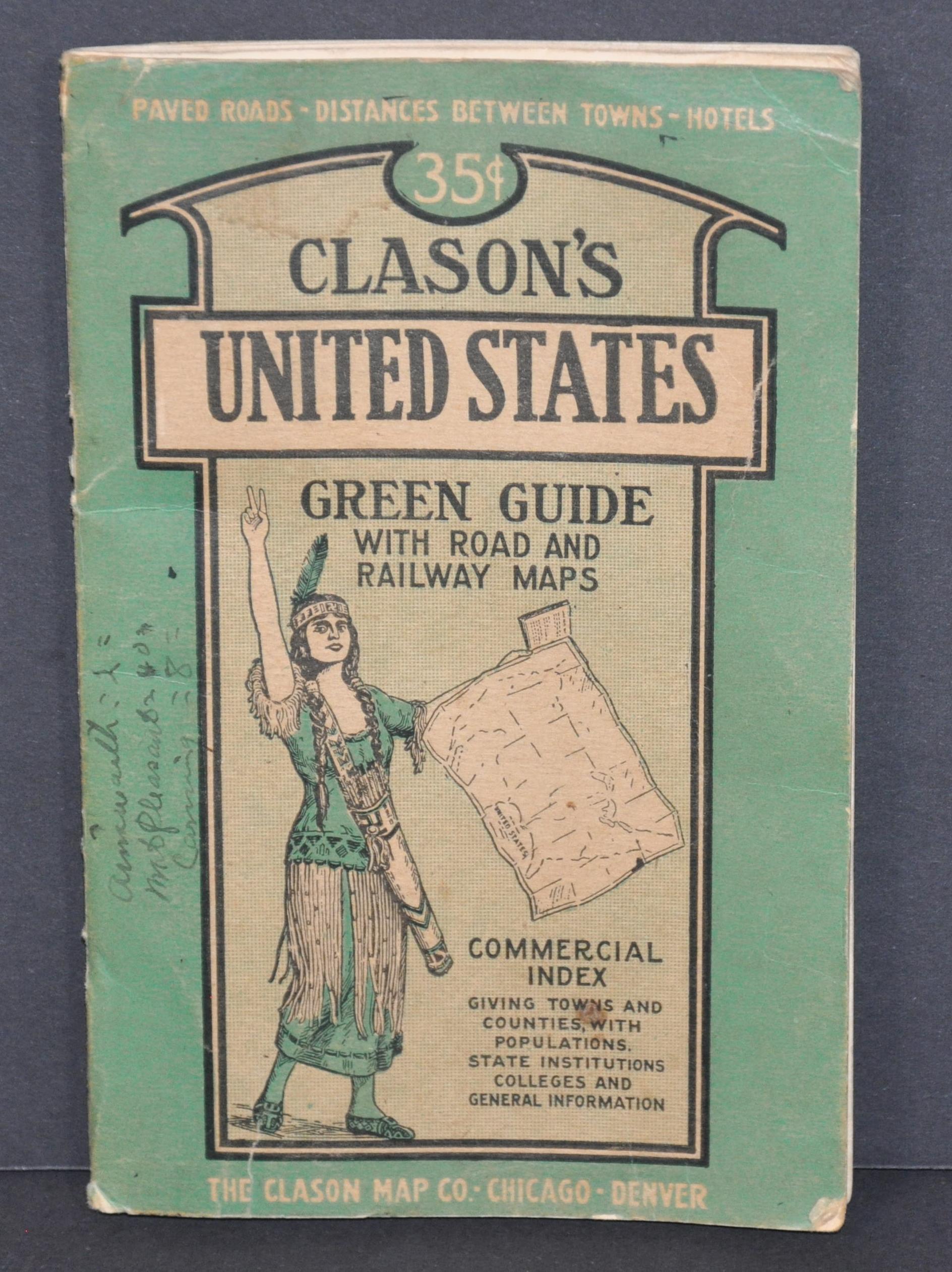


Clason's United States Green Guide - Spectacular overview of America's road network during the mid-1920s.
Clason Map Company
Date d'édition : 1924
Ancien(s) ou d'occasion
Vendeur
Curtis Wright Maps, Berwyn, IL, Etats-Unis
Évaluation du vendeur 4 sur 5 étoiles
![]()
Vendeur AbeBooks depuis 15 février 2023
Nous sommes désolés, ce livre n'est plus disponible. AbeBooks référence des millions de livres. Veuillez saisir des termes de recherche ci-dessous pour identifier des exemplaires similaires.
A propos de cet article
Description :
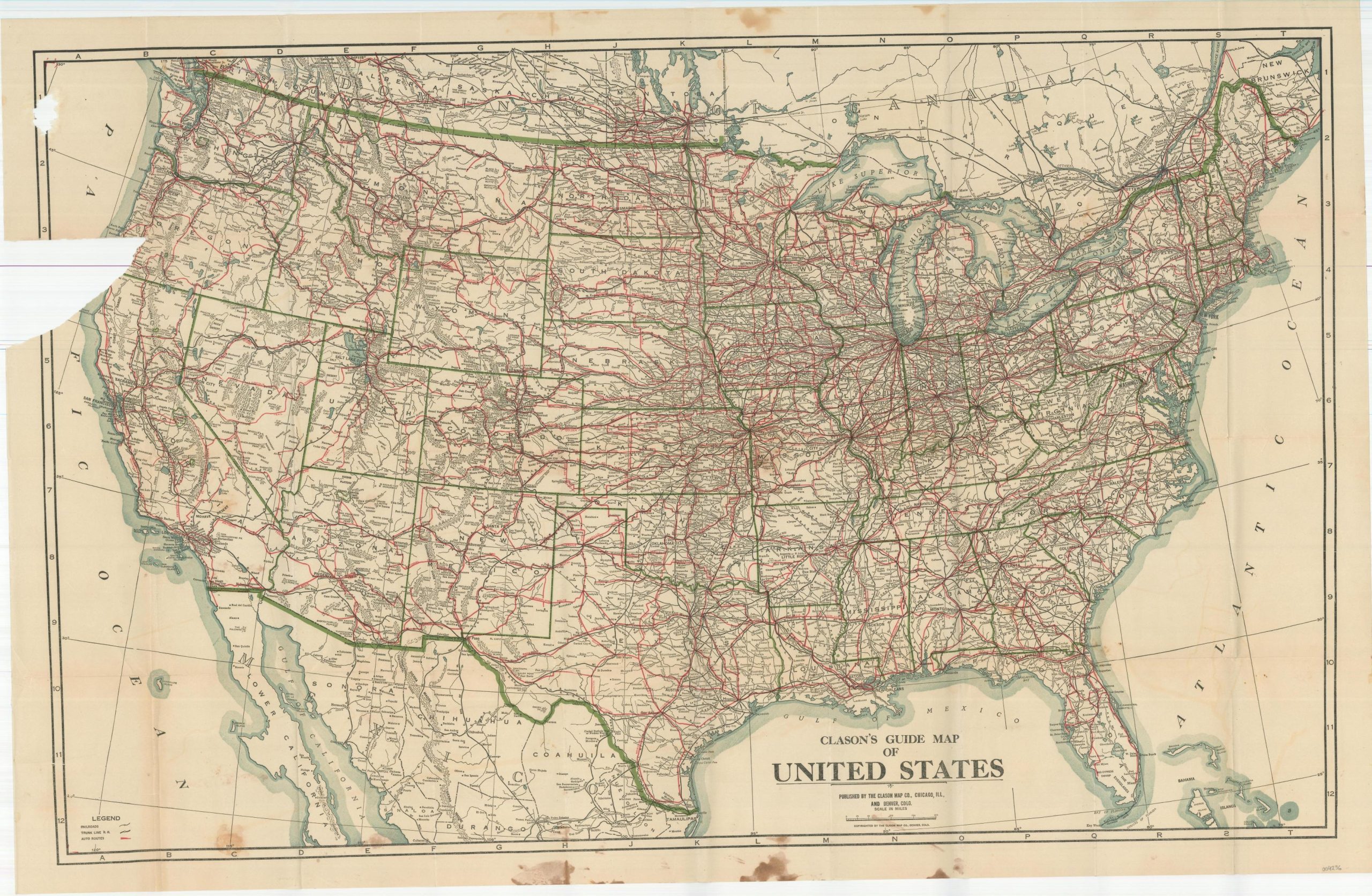
"According to some incredible research by Carl Liedholm of Michigan State University, the Clason Map Company of Denver, Colorado first started creating pocket guides in 1906, three years after its earliest maps were issued. These were focused on the cities of Denver and Colorado Springs, but would eventually broaden to encompass entire states. In 1908, the iconic green covers were introduced, and in 1920 the name 'Green Guide' was formally adopted. Liedholm states; "The Green Guides were a unique product of the Clason Map Company. They were pocket-sized (approximately 4" x 6") guides that were published for many states and several cities. Each guide consisted of a booklet, ranging in length from 15 to over 60 pages with detailed information about the state or city, and one or more large maps that were pasted within the covers. Each of the state guides included a commercial index of the cities and towns that provided information on their individual populations, elevations, industries, hotels, and banks. In addition, there was general information about the state that would be of interest to the traveler on such topics as state history, scenic wonders, national parks, roads, railways, and "interesting facts about the state." Downtown city maps and pictures were incorporated into the textual descriptions." This is a fine example of the 1924 edition of Clason's Green Guide of the United States, the same year the covers were updated to advertise Clason Atlases. To the front cover is attached a folding map of the Transcontinental Trails of the United States. Pole markings reflect the haphazard organization of the auto trails the year prior to the organization of the U.S. Numbered Highway System. A second folding map, disbound, shows the main automobile roads in addition to railways, towns, and geographic features. The guidebook includes a wealth of information on National Parks and National Monuments, an index of cities, rivers, and routes, road sign descriptions, and a view of the Capitol Building in Washington, D.C., in addition to the aforementioned generalized contents. Source." Sheet Width (in) See Description Sheet Height (in) See Description Condition Description "40 pp. guidebook with illustrated stiff green paper wraps. One folding map measuring of the U.S. measuring 12.5" x 16.25" remains affixed to the front cover and is in good condition, with a few small edge tears and light wear. A second, larger, map measures approximately 33.75" x 21.5" and was roughly disbound. The upper left corner shows heavy repairs on the verso and minor image loss along the old tears. Moderate staining present in the upper and lower margins, entering the neatline in just a few places to affect the image. About good condition overall.". N° de réf. du vendeur 4236
Détails bibliographiques
Titre : Clason's United States Green Guide - ...
Date d'édition : 1924
Etat : Very Good
AbeBooks vous offre des millions de livres anciens, neufs, d'occasion et épuisés proposés par des milliers de vendeurs du monde entier. Acheter sur AbeBooks est simple, sűr et 100% sécurisé - effectuez votre recherche, passez commande sur notre site sécurisé et recevez votre ouvrage directement expédié par le vendeur.
Cherchez parmi des millions de livres proposés par des milliers de vendeurs
Livres anciens et de collection
Livres rares, manuscrits, incunables ou livres signés, découvrez notre page consacrée aux livres anciens et de collection.
Editions originales
Tirages limités, éditions spéciales ou numérotées, retrouvez notre sélection d'éditions originales.
Livres d'occasion
Meilleures ventes, idées lecture et lauréats ŕ prix réduits, faites des économies grâce ŕ nos bonnes affaires et ŕ la livraison gratuite.