Montant total (1 article articles) :
Destination de la commande :

champlain sieur (5 résultats)
Commentaires
Passer aux résultats principaux de la recherche
Filtres de recherche
Type d'article
- Tous les types de produits
- Livres (4)
- Magazines & Périodiques (Aucun autre résultat ne correspond ŕ ces critčres)
- Bandes dessinées (Aucun autre résultat ne correspond ŕ ces critčres)
- Partitions de musique (Aucun autre résultat ne correspond ŕ ces critčres)
- Art, Affiches et Gravures (Aucun autre résultat ne correspond ŕ ces critčres)
- Photographies (Aucun autre résultat ne correspond ŕ ces critčres)
- Cartes (1)
- Manuscrits & Papiers anciens (Aucun autre résultat ne correspond ŕ ces critčres)
Etat En savoir plus
- Neuf (Aucun autre résultat ne correspond ŕ ces critčres)
- Comme neuf, Trčs bon ou Bon (1)
- Assez bon ou satisfaisant (3)
- Moyen ou mauvais (Aucun autre résultat ne correspond ŕ ces critčres)
- Conformément ŕ la description (1)
Reliure
- Toutes
- Couverture rigide (4)
- Couverture souple (Aucun autre résultat ne correspond ŕ ces critčres)
Particularités
- Ed. originale (3)
- Signé (Aucun autre résultat ne correspond ŕ ces critčres)
- Jaquette (Aucun autre résultat ne correspond ŕ ces critčres)
- Avec images (4)
- Sans impressions ŕ la demande (5)
Langue (1)
Livraison gratuite
Pays
Evaluation du vendeur
-

VOYAGES OF SAMUEL DE CHAMPLAIN 1604 1618 ACADIA, LONG ISLAND, NORUMBEGA COAST, GREAT AUK, FUR TRADE, BASQUE TROUBLE, QUEBEC SCURVY, ETIENNE BRULE 1610, IROQUOIS CAPTURE, OTTAWAHURONS, FRIARS AND PRIESTS
Edité par BARNES AND NOBLE, 1967
Vendeur : forest primeval, Cherry tree, PA, Etats-Unis
Évaluation du vendeur 3 sur 5 étoiles

EUR 7,86
Autre deviseEUR 5,94 expédition vers Etats-UnisQuantité disponible : 1 disponible(s)
Ajouter au panierHard cover. Reprint. BARNES AND NOBLE, 1967. Reprint. . Good. Ex-library. VERY CLEAN, CRISP. 374 p. Includes: maps, index. loc voyages Good. Ex-library. VERY CLEAN, CRISP.
-
Champlain's Voyages, 1613 & 1632
Edité par Berjon & Sevestre, Paris, 1613
Vendeur : Arader Books, New York, NY, Etats-Unis
Évaluation du vendeur 5 sur 5 étoiles

Edition originale
EUR 642 167,14
Autre deviseGratuit expédition vers Etats-UnisQuantité disponible : 1 disponible(s)
Ajouter au panierHardcover. Etat : Very good. First. THE ULTIMATE SET OF CANADIAN AMERICANA. Champlain's 1613 account of his first four voyages to New France, and his comprehensive 1632 revision of the account up to 1631, including some of the most important and influential maps of the New World. The 1613 first edition is quite rare, and in exceptional state (with two maps supplied in facsimile). The 1632 revised edition, one of the great treatises on the topography, flora & fauna, people and climate of North America before extensive European settlement, is an exceptionally distinguished copy in a contemporary armorial binding. There can be no greater pair to establish (or to crown) a collection of Americana, Canadiana or Voyages. Please see the listings for the individual copies for full descriptions, or inquire to be sent a complete collation and description of both copies.
-
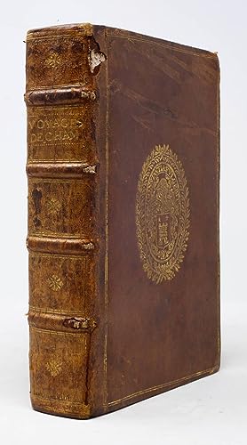
Les Voyages du Sieur de Champlain Xaintongeois, Capitaine ordinaire pour le Roy, en la marine. Divisez en deux livres. ou, Iournal tres-fidele des observations faites és descouvertes de la Nouvelle France: tant en la descriptio[n] des terres, costes rivieres, ports, havres, leurs hauteurs, & plusieurs declinaisons de la guide-aymant; qu'en la creace des peuples, leur super-stition, façon de vivre & de guerroyer: enrichi de quantité de figures. Ensemble deux cartes geographiques: la premiere servant ŕ la navigation, dressée selon les compas qui nordestent, sur lesquels les marinier navigent: ŕ laquelle est adiousté le voyage du destroict qu'ont trouvé les Anglois, au dessus de Labrador, depuis le 53e. degré de latitude, iusques au 63e. en l'an 1612. cerchans un chemin par le Nord, pour aller ŕ la Chine
Edité par Jean Berjon, Paris, 1613
Vendeur : Arader Books, New York, NY, Etats-Unis
Évaluation du vendeur 5 sur 5 étoiles
Edition originale
EUR 412 821,73
Autre deviseGratuit expédition vers Etats-UnisQuantité disponible : 1 disponible(s)
Ajouter au panierHardcover. Etat : Very good. First. First edition. Paris: Chez Iean Berjon, 1613. Quarto (8 1/2" x 6 9/16", 216mm x 167mm). [Full collation available.] With 11 folding engraved plates (of which 8 are maps, of which 2 are facsimiles) plus 13 in-text engravings and 1 in-text woodcut. Bound in 1889 by W. Pratt for H. Stevens & Son in red morocco (rebacked, with the original backstrip laid down). On the covers, a triple gilt fillet border surrounding a triple-gilt fillet panel, with outside-corner gilt fleurons and inside-corner gilt branch-sprays. On the spine five raised bands with a gilt fillet. Gilt florals in the panels. Title gilt to the second panel, imprint gilt to the third panel. Five pairs of gilt fillets to the head- and tail-pieces. Double gilt fillet to the edges of the boards. Gilt inside dentelle. Marbled end-papers. All edges of the text-block gilt. Rebacked, with the original backstrip laid down. Fore-corners restored. Two maps (Burden 160 & 170) present only in facsimile. Evenly mildly tanned throughout. With a couple of early ink annotations to the dedicatory poem (?1r-v). Some scattered marginal repairs. A lovely copy in a sumptuous binding. Samuel de Champlain (1567-1635) was the great French navigator-explorer of Canada, founder of Quebec City and governor of Nouvelle France (the whole of the French colonial territory in America, less Acadia, Louisiana and the cities of Trois-Rivičres and Montréal). The present item is the first published account of his voyage to and exploration of the northern part of France's vast American territory in the XVIIc, which would essentially collapse by 1763. Though Champlain would go on to traverse the Atlantic some two dozen times, here he includes accounts of his four voyages to America: 1604, 1610, 1611 and 1613. Champlain was, as Burden notes, "the first truly scientific cartographer of North America," and a crucial player in France's territorial expansion on the continent. Although one of the celebrated maps is in facsimile, the other vital map ("Carte geographique de la Novelle franse en sonaray meridien") is present in the second state, with the Ottawa River depicted (Burden 161). His maps are festooned with flora and fauna, indicating to France the limitless bounty of the New World; their aim is not just historical but political and persuasive. Church 360; Burden 161, 166-169, 171-181; Sabin 11835.
-
Les Voyages de la Nouvelle France occidentale, dicte Canada, faits par le S.r de Champlain Xainctongeois, Capitaine pour le Roy en la Marine du Ponant, & toutes les Descouvertes qu'il a faites en ce paďs depuis l'an 1603 iusques en l'an 1629. avec ce qui s'est paßé en ladite Nouvelle France en l'année 1631
Edité par Chez Louis Sevestre, Paris, 1632
Vendeur : Arader Books, New York, NY, Etats-Unis
Évaluation du vendeur 5 sur 5 étoiles
EUR 266 040,67
Autre deviseGratuit expédition vers Etats-UnisQuantité disponible : 1 disponible(s)
Ajouter au panierHardcover. Etat : Very good. Second. Revised edition, second state. Paris: Chez Louis Sevestre, 1632. Quarto (8 7/8" x 6 7/16", 206mm x 163mm). [Full collation available.] With six in-text engraved plates, two in-text woodcuts and a large folding engraved map. Bound in contemporary armorial calf. On the boards, a double gilt fillet border. Gilt supralibros of Marc-Antoine du Sauzay. On the spine, four raised bands. In the panels, a gilt central fleuron within a double gilt fillet border. Title (VOYAGES/DE.CHAM.) gilt to the second panel. Gilt rolls to the head- and tail-pieces. Gilt rolls to the edges of the boards. All edges of the text-block speckled red. Wear along the front hinge, with a patch of wear at the upper edge of the front board. Some cracking and sunning to the spine. Some skinning to the boards. A little rubbing to the extremities. Internally some foxing, with passages of even tanning. Marginal repairs to T4 and 3G3 (affecting a few letters, supplied in manuscript). A few repaired tears to the map, but very good. Effaced bookplates of the Bibliothčque [.] (post-1802) and of the Bibliothčque du Chateau [.] to the front paste-down. Bookseller ticket of Libraire Thomas-Scheler Paris to the front paste-down. Signed bookplate of Bruce McKinney designed and printed by E.M. Ginger. Samuel de Champlain (1567-1635) was the great French navigator-explorer of Canada, founder of Quebec City and governor of Nouvelle France (the whole of the French colonial territory in America, less Acadia, Louisiana and the cities of Trois-Rivičres and Montréal). The first account of his voyages was published in 1613, but the present item is revised all the way to the year before its publication, and is considerably augmented (Church calls this "perhaps the most important of the old editions"). The work did much to encourage the colonization and settlement of New France. The cancellation of D2.3 is found in most copies, being a revision to remove a potentially offensive passage to Cardinal Richelieu, who preceded Champlain as governor. Church notes that several imprints are found, but that the work itself is identical. The map, stretching as far south as Virginia, is an improvement on Champlain's 1616 map, with much more detailed and accurate topography. It is also perhaps the first representation of a settlement in New York City: a church at the southern end of a peninsular Manhattan. At the end is Champlain's guide to navigation, based on his roughly two dozen crossings of the Atlantic. In addition to Champlain's accounts, there are parallel (French-"Canadois" i.e., Huron-Wyandot) religious texts by the Jesuit Ledesme: a catechism translated by Brebuf (SJ), and a series of prayers (Paternoster, Ave Maria, Creed etc.) translated by Massé (SJ). The binder, Marc-Antoine du Sauzay (Sausay, Sausey), seigneur de Varennes, la Moličre et Jarnosse (1622-1708) was a king's counselor and prévôt des marchands (not unlike the mayor) of Lyon, among other honors. He was just the sort of person who would have had curiosity about or indeed financial interests in Canada. (The supralibros bears the monogram CDS, his father Claude du Sauzay; he used the same stamp but added the laurel wreath as a mark of difference.) The next known owner was Pierre S. du Pont III (1911-1988; his sale, Christie's New York, 8 October 1991, lot 39), member of the distinguished Delaware family synonymous with gunpowder and now broader chemical manufacture. Champlain was the nephew and protégé of François Gravé du Pont, but the families are not related. His Christie's sale was a formidable collection of navigation and voyages. The book then passed into the collection of Bruce McKinney (Bloomsbury New York, 3 December 2009 "The De Orbe Novo Collection: Exploration in the New World", lot 69). McKinney founded the Americana Exchange, now Rare Book Hub, the central database of book auction records. Church 420, Field 268, Harrisse 51, Lande 118 (lacking the map), Sabin 11839, Streeter VI:3621.
-
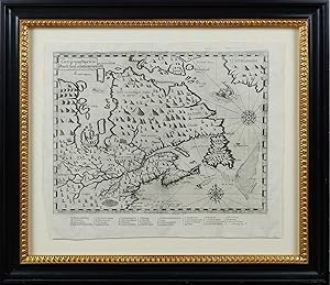
Carte geographique de la Nouelle franse en son vray meridiein
Edité par Iean Berjon, Paris, 1613
Vendeur : Arader Books, New York, NY, Etats-Unis
Évaluation du vendeur 5 sur 5 étoiles
Carte Edition originale
EUR 114 672,70
Autre deviseGratuit expédition vers Etats-UnisQuantité disponible : 1 disponible(s)
Ajouter au panierNo binding. Etat : Near fine. First. First edition, second state. From Les Voyages du Sieur de Champlain Xaintongeois. . . Paris: Chez Iean Berjon, 1613. Copperplate engraving on a single sheet (12 1/8" x 14 7/8", 308mm x 379mm; neat-line: 240mm x 323mm). Framed floating behind Museum Glass. A dark impression with plate tone. Not viewed out of frame. Samuel de Champlain (1567-1635) was the great French navigator-explorer of Canada, founder of Quebec City and governor of Nouvelle France (the whole of the French colonial territory in America, less Acadia, Louisiana and the cities of Trois-Rivičres and Montréal). The present item is the first published account of his voyage to and exploration of the northern part of France's vast American territory in the XVIIc, which would essentially collapse by 1763. Though Champlain would go on to traverse the Atlantic some two dozen times, here he includes accounts of his four voyages to America: 1604, 1610, 1611 and 1613. Champlain was, as Burden notes, "the first truly scientific cartographer of North America," and a crucial player in France's territorial expansion on the continent. The present map is in Burden and Kershaw's second state, distinguishable by the changed title (".en son vray mondia" in the first state), by the sea-monster between Greenland and Labrador (a ship in the first state) and the addition for the first time of Champlain's name at bottom center ("Faictte par le Sr Champlain Cappine po~ le Roy en la marine-- 1613"). Kershaw opines that "the publisher had already started to print this map when Champlain returned to France in 1613 with additional information on the location of the Ottawa River, as well as on the Indian tribes of the Ottawa Valley." Indeed, the second state of the map contains considerably more detail about the region south of Hudson's Bay (its label in English as "the bay wher hud/son did winter"), especially noting mountains and ranges that could frustrate further exploration. Burden (ad loc.) notes that the present map "depicts latitude but longitude also, something virtually never attempted before on a North American map of such detail. Champlain's acute awareness of the deviation of the compass enables him to portray the St. Lawrence River in its more correct south-west to north-east flow rather than the more usual west to east seen on maps of the period." Burden 161; Kershaw, Early Printed Maps of Canada 62.

![Image du vendeur pour Les Voyages du Sieur de Champlain Xaintongeois, Capitaine ordinaire pour le Roy, en la marine. Divisez en deux livres. ou, Iournal tres-fidele des observations faites és descouvertes de la Nouvelle France: tant en la descriptio[n] des terres, costes rivieres, ports, havres, leurs hauteurs, & plusieurs declinaisons de la guide-aymant; qu'en la creace des peuples, leur super-stition, façon de vivre & de guerroyer: enrichi de quantité de figures. Ensemble deux cartes geographiques: la premiere servant ŕ la navigation, dressée selon les compas qui nordestent, sur lesquels les marinier navigent: ŕ laquelle est adiousté le voyage du destroict qu'ont trouvé les Anglois, au dessus de Labrador, depuis le 53e. degré de latitude, iusques au 63e. en l'an 1612. cerchans un chemin par le Nord, pour aller ŕ la Chine mis en vente par Arader Books](https://pictures.abebooks.com/inventory/md/md30884498316.jpg)