
Gream thomas (3 résultats)
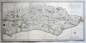
Edité par W.Faden, 1799
- Couverture souple
- Carte
Vendeur : Angelika C. J. Friebe Ltd. - MapWoman, Dorking, Royaume-UniAngelika C. J. Friebe Ltd. - MapWoman
Contacter le vendeurVendeur avec une évaluation de 5 étoilesEtat: Occasion - Assez bon
EUR 605,92
EUR 23,53 expéditionExpédition depuis Royaume-Uni vers Etats-UnisQuantité disponible : 1 disponible(s)
Ajouter au panierSoft cover. Etat : Very Good. W.Faden London 1799.- copper engraved map with old hand colouring; overall size 37 x 80 cm; map size 36,5 x 79 cm.- A very detailed folding map of Sussex by Thomas Gream, published by W.Faden. 12 segments on linen, without slipcase.- paper cream coloured; some occasional discolouration; some faint f…oxing; top left corner missing but not affecting image; w/out slip case; o/w vg cond. - [ref: 3047 ].
 Autres images
Edité par William Faden, 1819
- Carte
Vendeur : Morning Mist Books and Maps, Cirencester, Royaume-UniMorning Mist Books and Maps
Contacter le vendeurVendeur avec une évaluation de 5 étoilesEtat: Occasion - Satisfaisant
EUR 193,90
EUR 52,94 expéditionExpédition depuis Royaume-Uni vers Etats-UnisQuantité disponible : 1 disponible(s)
Ajouter au panierNo Binding. Etat : Good. Folding map in contemporary slipcase. 7x2 panels mounted on linen: linen bright with only light wear, no holes and no tears. General toning to the map with significant 'ghosting' (see accompanying photos). Outline colouring to 'Rapes'. Parks in green with faint blue colouring to water courses/marshes. Ro…ads coloured. Some landscape features shown by hachuring. Some coastal features. Intended route of the Arun/Portsmouth Canal marked as a dotted line. Slipcase heavily worn with loss to sides. Sheet size: 38.5cm by 80.5cm approx. Further details available on request. (n506).
 Autres images
- Carte
Vendeur : Altea Antique Maps, London, Royaume-UniAltea Antique Maps
Contacter le vendeurVendeur avec une évaluation de 5 étoilesEtat: Occasion
EUR 2 423,70
EUR 41,18 expéditionExpédition depuis Royaume-Uni vers Etats-UnisQuantité disponible : 1 disponible(s)
Ajouter au panierLondon: William Faden, 1795. Fine original body colour. Four sheets, dissected and laid on linen in four sections, edged with silk as issued, each section 805 x 510mm. Some faint offset. A large and detailed map of Sussex, important as the first published map of the county using the Board of Ordnance trigonometrical survey. Will…iam Gardner (1739-1800) and Thomas Yeakell (1758-87) originally intended that their survey of Sussex to be on a scale of two inches to a mile, with the eight sheets to be published over six years from 1778. However they needed to sell at least 400 subscriptions to meet the estimated cost of £2,400 but only sold 250, meaning their enterprise folded after the fourth plate was published in 1783, leaving half the county unmapped. In 1787 Yeakell died and Gardner joined the Ordnance as Chief Surveying Draftsman, although he maintained his private practice. With the encouragement of the Master-General of the Ordnance (Charles Lennox, Duke of Richmond), who allowed him access to William Mudge's trigonometrical survey, Gardner returned to his map of Sussex, working alongside surveyor Thomas Gream to complete it, although on a reduced scale. Their finished map was then engraved by Thomas Foot and published 1795 by William Faden, predating the first OS map (Kent) by six years. Not only did the map win Faden a gold medal from the Society of Arts, but it also became the template for other large scale county maps like the first Ordnance Survey maps and those of John & Christopher Greenwood. KINGSLEY: 57 state iii, same year as first state.


