
Montant total (1 article articles) :
Destination de la commande :

herisson eustache (28 résultats)
Passer aux résultats principaux de la recherche
Filtres de recherche
Type d'article
- Tous les types de produits
- Livres (21)
- Magazines & Périodiques (Aucun autre résultat ne correspond ŕ ces critčres)
- Bandes dessinées (Aucun autre résultat ne correspond ŕ ces critčres)
- Partitions de musique (Aucun autre résultat ne correspond ŕ ces critčres)
- Art, Affiches et Gravures (1)
- Photographies (Aucun autre résultat ne correspond ŕ ces critčres)
- Cartes (6)
- Manuscrits & Papiers anciens (Aucun autre résultat ne correspond ŕ ces critčres)
Etat En savoir plus
- Neuf (1)
- Comme neuf, Trčs bon ou Bon (1)
- Assez bon ou satisfaisant (19)
- Moyen ou mauvais (Aucun autre résultat ne correspond ŕ ces critčres)
- Conformément ŕ la description (7)
Particularités
- Ed. originale (Aucun autre résultat ne correspond ŕ ces critčres)
- Signé (Aucun autre résultat ne correspond ŕ ces critčres)
- Jaquette (Aucun autre résultat ne correspond ŕ ces critčres)
- Avec images (27)
- Sans impressions ŕ la demande (27)
Langue (3)
Prix
- Tous les prix
- Moins de EUR 20 (Aucun autre résultat ne correspond ŕ ces critčres)
- EUR 20 ŕ EUR 45
- Plus de EUR 45
Livraison gratuite
Pays
Evaluation du vendeur
-
La Russie 2eme Feuille. (Map with outline color)
Edité par Herisson Circa 1810, 1810
Vendeur : Zephyr Books LLC, Reno, NV, Etats-Unis
Membre d'association : ABAA ILAB IOBA
Évaluation du vendeur 5 sur 5 étoiles

EUR 30,84
Expédition ŕ EUR 5,35
Expédition nationale : Etats-UnisQuantité disponible : 1 disponible(s)
Ajouter au paniernot bound. Etat : Very Good. Image size: 18.2x23.5 cm. Copperplate engraving of Southern Russia with outline color from "Atlas Portatif, contenant la Geographie Universelle Ancienne et Moderne". Shows mountains, rivers and principal roadways. weight: 0.1 lb. Very good. Some marginal toning. Engraved by Glot. 25.5x20.4x0.1 cm. One Sheet.
-
La Perse. (Map with outline color)
Edité par Herisson Circa 1810, 1810
Vendeur : Zephyr Books LLC, Reno, NV, Etats-Unis
Membre d'association : ABAA ILAB IOBA
Évaluation du vendeur 5 sur 5 étoiles
EUR 30,84
Expédition ŕ EUR 5,35
Expédition nationale : Etats-UnisQuantité disponible : 1 disponible(s)
Ajouter au paniernot bound. Image size: 18.5x24 cm. Copperplate engraving of Persia with outline color from "Atlas Portatif, contenant la Geographie Universelle Ancienne et Moderne". Shows mountains, rivers, and principal roadways. weight: 0.1 lb. Very good, very small marginal dampstain, stitch holes to left margin. Engraved by Glot. 25.5x20.4x0.1 cm. One Sheet.
-
La Russie 2eme Feuille. (Map with outline color)
Edité par Herisson Circa 1810, 1810
Vendeur : Zephyr Books LLC, Reno, NV, Etats-Unis
Membre d'association : ABAA ILAB IOBA
Évaluation du vendeur 5 sur 5 étoiles
EUR 30,84
Expédition ŕ EUR 5,35
Expédition nationale : Etats-UnisQuantité disponible : 1 disponible(s)
Ajouter au paniernot bound. Etat : Very Good. Image size: 18.2x23.5 cm. Copperplate engraving of Southern Russia with outline color from "Atlas Portatif, contenant la Geographie Universelle Ancienne et Moderne". Shows mountains, rivers and principal roadways. weight: 0.1 lb. Very good. Some marginal toning. Engraved by Glot. 25.5x20.4x0.1 cm. One Sheet.
-
La Chine. (Map with outline color)
Edité par Herisson Circa 1810, 1810
Vendeur : Zephyr Books LLC, Reno, NV, Etats-Unis
Membre d'association : ABAA ILAB IOBA
Évaluation du vendeur 5 sur 5 étoiles
EUR 30,84
Expédition ŕ EUR 5,35
Expédition nationale : Etats-UnisQuantité disponible : 1 disponible(s)
Ajouter au paniernot bound. Etat : Very Good. Image size: 17.5x21.5 cm. Copperplate engraving of of the China, Korea and Japan with outline color from "Atlas Portatif, contenant la Geographie Universelle Ancienne et Moderne". Shows mountains, rivers, and principal roadways. weight: 0.1 lb. Very good. Moderate foxing. Engraved by Glot. 25.5x20.4x0.1 cm. One Sheet.
-
La Royaume de Hollande. (Map with outline color)
Edité par Herisson Circa 1810, 1810
Vendeur : Zephyr Books LLC, Reno, NV, Etats-Unis
Membre d'association : ABAA ILAB IOBA
Évaluation du vendeur 5 sur 5 étoiles
EUR 30,84
Expédition ŕ EUR 5,35
Expédition nationale : Etats-UnisQuantité disponible : 1 disponible(s)
Ajouter au paniernot bound. Etat : Very Good. Image size: 18.7x23.2 cm. Copperplate engraving of Holland with outline color from "Atlas Portatif, contenant la Geographie Universelle Ancienne et Moderne". Shows mountains, rivers and principal roadways. weight: 0.1 lb. Very good. Some marginal toning. Engraved by Glot. 25.5x20.4x0.1 cm. One Sheet.
-
La Gaule (Map with outline color)
Edité par Herisson Circa 1810, 1810
Vendeur : Zephyr Books LLC, Reno, NV, Etats-Unis
Membre d'association : ABAA ILAB IOBA
Évaluation du vendeur 5 sur 5 étoiles
EUR 30,84
Expédition ŕ EUR 5,35
Expédition nationale : Etats-UnisQuantité disponible : 1 disponible(s)
Ajouter au paniernot bound. Etat : Very Good. Image size: 24x18.5 cm. Copperplate engraving of France and Belgium with outline color from "Atlas Portatif, contenant la Geographie Universelle Ancienne et Moderne". Shows mountains, rivers and principal roadways. weight: 0.1 lb. Very good. Some marginal toning. Engraved by Glot. 25.5x20.4x0.1 cm. One Sheet.
-
L'Ecosse (Map with outline color)
Edité par Herisson Circa 1810, 1810
Vendeur : Zephyr Books LLC, Reno, NV, Etats-Unis
Membre d'association : ABAA ILAB IOBA
Évaluation du vendeur 5 sur 5 étoiles
EUR 30,84
Expédition ŕ EUR 5,35
Expédition nationale : Etats-UnisQuantité disponible : 1 disponible(s)
Ajouter au paniernot bound. Etat : Very Good. Image size: 18.1x21.2 cm. Copperplate engraving of Scotland with outline color from "Atlas Portatif, contenant la Geographie Universelle Ancienne et Moderne". Inset of Shetland Islands. Shows mountains, rivers and principal roadways. weight: 0.1 lb. Very good. Some marginal toning. Engraved by Glot. 25.5x20.4x0.1 cm. One Sheet.
-
La Russie 1eme Feuille. (Map with outline color)
Edité par Herisson Circa 1810, 1810
Vendeur : Zephyr Books LLC, Reno, NV, Etats-Unis
Membre d'association : ABAA ILAB IOBA
Évaluation du vendeur 5 sur 5 étoiles
EUR 30,84
Expédition ŕ EUR 5,35
Expédition nationale : Etats-UnisQuantité disponible : 1 disponible(s)
Ajouter au paniernot bound. Etat : Very Good. Image size: 18.2x23.3 cm. Copperplate engraving of Northern Russia with outline color from "Atlas Portatif, contenant la Geographie Universelle Ancienne et Moderne". Shows mountains, rivers and principal roadways. weight: 0.1 lb. Very good. Some marginal toning. Engraved by Glot. 25.5x20.4x0.1 cm. One Sheet.
-
La Barbarie. (Map with outline color)
Edité par Herisson Circa 1810, 1810
Vendeur : Zephyr Books LLC, Reno, NV, Etats-Unis
Membre d'association : ABAA ILAB IOBA
Évaluation du vendeur 5 sur 5 étoiles
EUR 30,84
Expédition ŕ EUR 5,35
Expédition nationale : Etats-UnisQuantité disponible : 1 disponible(s)
Ajouter au paniernot bound. Etat : Very Good. Image size: 17.7x21.5 cm. Copperplate engraving of Of Barbary with outline color from "Atlas Portatif, contenant la Geographie Universelle Ancienne et Moderne". Shows The Sahara Desert as far south as Timbuktu. Shows mountains, and rivers and principal cities. weight: 0.1 lb. Very good. Some marginal toning. Engraved by Glot. 25.5x20.4x0.1 cm. One Sheet.
-
La Grande Tartarie. (Map with outline color)
Edité par Herisson Circa 1810, 1810
Vendeur : Zephyr Books LLC, Reno, NV, Etats-Unis
Membre d'association : ABAA ILAB IOBA
Évaluation du vendeur 5 sur 5 étoiles
EUR 30,84
Expédition ŕ EUR 5,35
Expédition nationale : Etats-UnisQuantité disponible : 1 disponible(s)
Ajouter au paniernot bound. Etat : Very Good. Image size: 17.5x21.4 cm. Copperplate engraving of Asia. with outline color from "Atlas Portatif, contenant la Geographie Universelle Ancienne et Moderne". Shows mountains, rivers, and principal roadways. weight: 0.1 lb. Very good. Some small damp spots, stitching holes, bottom edge somewhat worn. Engraved by Glot. 25.5x20.4x0.1 cm. One Sheet.
-
La Monde Connu des Anciens. (Map with outline color)
Edité par Herisson Circa 1810, 1810
Vendeur : Zephyr Books LLC, Reno, NV, Etats-Unis
Membre d'association : ABAA ILAB IOBA
Évaluation du vendeur 5 sur 5 étoiles
EUR 30,84
Expédition ŕ EUR 5,35
Expédition nationale : Etats-UnisQuantité disponible : 1 disponible(s)
Ajouter au paniernot bound. Etat : Very Good. Image size: 17.6x22 cm. Copperplate engraving of Of the Ancient World. with outline color from "Atlas Portatif, contenant la Geographie Universelle Ancienne et Moderne". Shows the western ancient world from the Maylay peninsula on the east to western Africa and north to the Barents Sea. weight: 0.1 lb. Very good. Some marginal toning. Engraved by Glot. 25.5x20.4x0.1 cm. One Sheet.
-
La Turquie D'Asia. (Map with outline color)
Edité par Herisson Circa 1810, 1810
Vendeur : Zephyr Books LLC, Reno, NV, Etats-Unis
Membre d'association : ABAA ILAB IOBA
Évaluation du vendeur 5 sur 5 étoiles
EUR 30,84
Expédition ŕ EUR 5,35
Expédition nationale : Etats-UnisQuantité disponible : 1 disponible(s)
Ajouter au paniernot bound. Etat : Very Good. Image size: 17.5x21.7 cm. Copperplate engraving of the area bounded by the Caspian Sea, the Persian Gulf, The Mediterranean Sea, and the Black Sea. Country borders outlined in color. Map was originally included in "Atlas Portatif, contenant la Geographie Universelle Ancienne et Moderne". Shows mountains, rivers, and principal roadways. weight: 0.1 lb. Very good with marginal toning, marginal dampstain in top left corner, and sewing holes. Engraved by Glot. 25.5x20.4x0.1 cm. One Sheet.
-
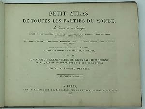
PETIT ATLAS DE TOUTES LES PARTIES DU MONDE,A L USAGE DE LA JEUNESSE.
Langue: français
Edité par Tardieu-Denesle, 1823
Vendeur : Librairie Voyage et Exploration, Cerny, France
Évaluation du vendeur 3 sur 5 étoiles

EUR 400
Expédition ŕ EUR 29
Expédition depuis France vers Etats-UnisQuantité disponible : 1 disponible(s)
Ajouter au panierCouverture rigide. Etat : Assez bon. " Petit Atlas de toutes les parties du Mondecontenant les découvertes des voyageurs modernes et l'état géographique de l'Europe, d'aprčs les derniers traités de paix." A Paris chez Tardieu-Denesle , Libraire, 1823. In-4 ŕ l'italienne (22,5 x 30 cm) bien complet des 21 cartes aux contours en couleurs, gravées au burin par Tardieu (certaines repliées), d'aprčs les dessins de M. Hérisson, Géographe ; et précédé d'un précis élémentaire de Géographie Moderne des cinq parties du monde, et de notions de la sphčre, par Madame Tardieu-Denesle . Léger manque de papier au coin de la carte de la France. Cartonnage marbré de l'époque. Dos lisse orné de frises et rosaces , coiffes et mors abîmés,déchirures sur une carte sans manque.
-
Carte des Régences d'Alger, de Tunis et de Tripoli (avec l'Empire de Maroc). Comprenant aussi tout le Bassin citérieur de la Méditerranée et une grande partie des Etats qui forment ses limites Européenes
Edité par Mme. Vve. Jean, París, 1841, 1841
Vendeur : MIQUELEIZ ANTIGUEDADES, PAMPLONA, NA, Espagne
Membre d'association : AILA ILAB
Évaluation du vendeur 5 sur 5 étoiles
EUR 80
Expédition ŕ EUR 30
Expédition depuis Espagne vers Etats-UnisQuantité disponible : 1 disponible(s)
Ajouter au panierEtat : Bueno. Mapa grabado al acero, 59x82 cm (huella)Manchas, bordes doblados, rasgadura sin pérdida en margen inferior, rasgadura con pérdida en margen izquierdo.
-
[Mapa] Carte d'Espagne et de Portugal ou se trouvent les grandes routes de postes
Edité par Paris, 1823
Vendeur : Bolivar Old Prints Anticuario, Barcelona, B, Espagne
Membre d'association : AILA ILAB
Évaluation du vendeur 5 sur 5 étoiles
Carte
EUR 220
Expédition ŕ EUR 25
Expédition depuis Espagne vers Etats-UnisQuantité disponible : 1 disponible(s)
Ajouter au panierSin Encuadernar - No binding. Etat : Bueno. 77x52. Gran mapa (77 x 52 cm) iluminado a mano de Espańa y Portugal por Eustache Herisson, prolífico cartógrafo francés de finales del siglo XVIII y antiguo alumno de Rigobert Bonne, fechado en 1823. Este mapa bien equilibrado abarca el sur de Francia, Espańa, las islas Baleares y el norte de África, destacando las rutas postales que atraviesan la Península Ibérica. El título del mapa y las escalas están ubicados en el lado izquierdo. Las subdivisiones territoriales están meticulosamente coloreadas a mano, y las características del relieve se representan detalladamente mediante hachuras. -------------------- A large (77 x 52 cm) hand-coloured map of Spain and Portugal by Eustache Herisson, a late XVIIIth-century and prolific French cartographer and past pupil of Rigobert Bonne, dated 1823. This well-balanced map encompasses southern France, Spain, the Balearic islands, and northern parts of Africa, highlighting postal routes running through the Peninsula. The map's title and scales all align on the left-hand side. Territorial subdivisions are delicately hand-coloured, and relief features are shown by hachures. FRA. Good.
-
![Image du vendeur pour [Mapa de Rusia] Carte de la Russie d'Europe divisée en ses nouveaux gouvernemens mis en vente par Bolivar Old Prints Anticuario](https://pictures.abebooks.com/inventory/md/md31791604568.jpg)
[Mapa de Rusia] Carte de la Russie d'Europe divisée en ses nouveaux gouvernemens
Edité par Paris, 1827
Vendeur : Bolivar Old Prints Anticuario, Barcelona, B, Espagne
Membre d'association : AILA ILAB
Évaluation du vendeur 5 sur 5 étoiles
Carte
EUR 290
Expédition ŕ EUR 25
Expédition depuis Espagne vers Etats-UnisQuantité disponible : 1 disponible(s)
Ajouter au panierSin Encuadernar. Etat : Bueno. Mapa antiguo de buen tamańo de la Rusia europea que abarca también los territorios actuales de Ucrania, Estonia, Letonia y partes de Moldavia y Polonia. De norte a sur abarca desde el océano glaciar ártico hasta el Mar Negro. Este mapa original fue realizado por Eustache Hérrison (1759-1818), cartógrafo e ingeniero francés activo en París hacia principios del siglo XIX. Fue alumno del destacado hidrógrafo Rigobert Bonne y fue miembro de la Société Royale. Gran parte de su trabajo fue vuelto a publicar póstumamente por Basset, Brué y otros. 52 x 76.5 cm. FRA. Very good.
-
Théatre Géographique des Guerres du Continent. Oů se trouvent en entier les Royaumes de Hollande, de Prusse, la Russie d'Europe, la Confédération du Rhin composéé des Royaumes de Saxe, de Westphalie, de Baviere et de Virtemberg, des Grands Duchés de Varsovie, de Berg, de Hesse Darm. de bade, et autres principautes, L'Empire d'Autriche, toute l'Italie comprenant le Royaume d'Italie, le Grand Duché de Toscane, les Etats de l'Eglise, le Royaume de Naples, et la Turquie d'Europe. Dressé par L. Denis, Revue et augmenté par Hérisson, élčve de M. Bonne, ancien ingénieur hydrographe de la Marine
Edité par A Paris: Chez Basset, Md. d'Estampes, 1809, 1809
Vendeur : Andarto B., Pamplona, NA, Espagne
Membre d'association : AILA ILAB
Évaluation du vendeur 5 sur 5 étoiles
Carte
EUR 850
Livraison gratuite
Expédition depuis Espagne vers Etats-UnisQuantité disponible : 1 disponible(s)
Ajouter au panierEncuadernación de tapa blanda. Etat : Bueno. [Para pedidos desde fuera de Espańa, por favor, consulte las condiciones de venta y envío, tipo B. / For orders to be delivered outside Spain, please, let you see our sale and shipping terms, type B. / Pour les commandes ŕ livrer hors d'Espagne, s'il vous plait, voyez les conditions de vente et de livraison, type B.].- // 2Ş edición actualizada.- // 1 mapa (1160x1190 mm.) compuesto en 16 planchas de 288x290 mm. grabadas en negro y coloreadas con acuarela (no enteladas).- // Proc.: Sin datos.- // Refs.: Edición desconocida a los bibliógrafos.- // Hojas de papel sin entelar, en carpeta de época de cartulina, con el título manuscrito en plano delantero Théatre des Guerres du Continent. Cubierta sucia y con tres pequeńos taladros; 1Ş plancha con un encolado original; pequeńa restauración en plancha 12; antiguos cercos de humedad en planchas 13, 14, 15 y 16, sin apenas afectar a los grabados.- //Este mapa, representando los frentes de guerra del ejército napoleónico en su avance hacia el Este, fue publicado en su primera versión en 1806, actualizándose su contenido a la situación de la guerra en otras dos ocasiones, en 1809 y en 1812 ?de esta se hizo una copia posterior en un momento indeterminado, manteniendo la fecha de 1812, que puede distinguirse, entre otros aspectos, por la mención ?Deposé á la Direction Générale de la Imprimerie et la Librairie? bajo el cartucho, y porque ofrece longitudes según dos meridianos, el de la Isla de Hierro arriba (aunque más bien parecen serlo según el de Cádiz) y el de París abajo? De las ediciones de 1806 y 1812, si no son bien conocidas, al menos se conservan ejemplares en diferentes países e instituciones, pero esta edición de 1809, intermedia, ha devenido tan rara, que ni siquiera puede encontrarse en la Bibliothčque nationale de France. Que se había publicado quedó avisado en el primer volumen de los Annales des sciences et des arts de 1809, publicados en 1810. Si en la edición de 1806 la cartela figuraba arriba a la derecha, en esta, como se repetirá después en la de 1812, aparece en la izquierda. Cádiz. Muestra las longitudes según un único meiridiano que, a tenor de la reedición posterior a 1812 sería según el meridiano de El Hierro, aunque más bien parecen serlo según el de Cádiz. Mapas.
-
(Carte routičre de l'Europe, Carte de l'Asie, Carte de l'Afrique, Carte des deux Amériques & Carte de l'Océanie comprenant la Malaisie, la Micronésie, la Mélanésie & la Polynésie) - (Suivant les derničres traités de paix pour l'instruction de la jeunesse). - The five continents bound together in a contemporary binding.
Edité par No ed., Paris, 1841
Vendeur : Emile Kerssemakers ILAB, Heerlen, Pays-Bas
Membre d'association : ILAB NVVA
Évaluation du vendeur 5 sur 5 étoiles
EUR 750
Expédition ŕ EUR 44
Expédition depuis Pays-Bas vers Etats-UnisQuantité disponible : 1 disponible(s)
Ajouter au panierLarge 4to (29x22 cm). Contemporary half leather, spine gilt; covers with decorated paper (corners bumped and sl. damaged). 5 sectionary maps pasted on linen. Linen seriously browned & small holes in folts, but not at all affecting the maps . - Maps in colour. Each map 70x50 cm, folded in 8 sections. - All the maps in nice condition. 1100g.
-

THEATRE GEOGRAPHIQUE DES GUERRES DU CONTINENT. OU SE TROUVENT EN ENTIER LES ROYAUMES DE HOLLANDE, DE BAVIERE, DE VIRTENBERG, DE PRUSSE, DE HONGRIE, DE BOHEME, L?EMPIRE D?AUTRICHE ET LES AUTRES ETATS SOUVERAINS D?ALLEMAGNE, LA RUSSIE D?EUROPE, TOUTE L?ITALIE COMPRENANT LE ROYAUME D?ITALIE, LE ROYAUME D?ETRURIE, LES ETATS DE L?EGLISE ET LE ROYAUME DE NAPLES, ENFIN LA TURQUIE D?EUROPE. DRESSE PAR L. DENIS, REVU ET AUGMENTE PAR HERISSON, ELEVE DE M. BONNE, ANCIEN INGENIEUR HYDROGRAPHE DE LA MARINE.
Edité par A PARIS. BASSET, MD D?ESTAMPES., 1806
Vendeur : Librairie du Château de Capens, Capens, France
Évaluation du vendeur 5 sur 5 étoiles
EUR 800
Expédition ŕ EUR 53,40
Expédition depuis France vers Etats-UnisQuantité disponible : 1 disponible(s)
Ajouter au panierGRANDE CARTE ENTOILEE, GRAVEE EN NOIR, LIMITES REHAUSSEES EN COULEURS, REPLIEE DE 120 X 100 CENTIMETRES ENVIRON, COMPOSEE DE 28 PLANCHES DE 25 X 17 CENTIMETRES. PREMIER TIRAGE RARE. DANS SON ETUI CARTONNE D?ORIGINE, COULEUR SAUMON, POURTOURS ENCADRES D?UNE DENTELLE DOREE, TITRE DORE SUR ETIQUETTE BLEUE AU CENTRE DU PLAT SUPERIEUR. PETITS DEFAUTS EXTERIEURS SUR L?ETUI, SINON CARTE EN TRES BEL ETAT.
-
Nouvel Atlas portatif, contenant la geographie universelle, ancienne et moderne.
Langue: allemand
Edité par Paris, Desray,, 1810
Vendeur : Matthaeus Truppe Antiquariat, Graz, Autriche
Membre d'association : ILAB VDAO
Évaluation du vendeur 4 sur 5 étoiles

EUR 321
Expédition ŕ EUR 62
Expédition depuis Autriche vers Etats-UnisQuantité disponible : 1 disponible(s)
Ajouter au panierVII, 161 S. 49 altkolorierte Kupferstichkarten. "Cet atlas, composé de 49 cartes nouvellement dessinées par M. Hérisson, et gravées au burin sans eau forte, par Glot, offre les découvertes des Voyageurs et l`état actuel de la science géographique, les noms donnés aux terres reconnues par les derniers Navigateurs ; les nouvelles divisions et dénominations politiques etablies par suite des traites de Presbourg, de Tilsit et die Vienne; . est précédé d`Elémens de Géographie, extraits des meilleurs Auteurs anciens et modernes, nationaux et étrangers, conformes aux cartes que l`auteur vient de dessiner de nouveau sur une échelle un peu plus grande que celle qui avoit été adoptée pour les premičres éditions. Pour servir aux Militaires, aux Négocians et aux Voyageurs, pour lesquels on a tracé les principales routes ; ŕ l`instruction de la Jeunesse, ŕ la lecture de l`Histoire et ŕ celle des voyages, des Feuilles publiques, etc. etc." (Titel). - Karte Nr. 1 knapp bis ins Bild beschnitten, Karte Nr. 7 fehlt das rechte Drittel, Karte Nr. 24 fehlen rechts ca. 2 cm des Bildes. - Vorsätze unsachgemäß erneuet. Buchinndeckel mit hs. Notizen. Text teils knitterfaltig und Vortitel mit Randläsuren. Etw. gebräunt, stellenw. etw. fleckig. Kl. Randläsuren. *** *** Copyright: Matthaeus TRUPPE Buchhandlung & Antiquariat - Stubenberggasse 7 - A-8010 Graz - ++43 (0)316 - 829552 *** *** Sprache: Deutsch Gewicht in Gramm: 500 Quer-Kl.-4°. HLdr. der Zeit mit Rückenschild (bestoßen und beschabt).
-
Carte de l'Amérique septentrionale et méridionale (.)
Langue: français
Edité par A.H. Basset, 1828
Vendeur : Antiquariaat Dat Narrenschip, Middelburg, Pays-Bas
Membre d'association : ILAB NVVA
Évaluation du vendeur 5 sur 5 étoiles
Carte
EUR 580
Expédition ŕ EUR 27
Expédition depuis Pays-Bas vers Etats-UnisQuantité disponible : 1 disponible(s)
Ajouter au panierNo Binding. Etat : Good. Antique map of North and South America, Western Europe and Western Africa. New Zealand on the left. The map shows the routes from Cook, Mackenzie and Vancouver. Title and imprint top left. Scale sticks bottom left. In the corner top right a map of St. Domingue (Hispaniola) and bottom right a map of Martinique. Rare map. Hand-coloured copper engraving, published in 1828 by A.H. Basset. The map was originally made by Eustache Hérisson and Rigobert Bonne. Dimensions (picture) 53 x 77 cm.
-
Carte de l?empire Ottoman contenant la Turquie d?Europe et d?Asie.
Edité par 0
Vendeur : Librairie du Levant, Bayonne, France
Évaluation du vendeur 1 sur 5 étoiles

EUR 280
Expédition ŕ EUR 6
Expédition depuis France vers Etats-UnisQuantité disponible : 1 disponible(s)
Ajouter au panierCarte dressée par Eustache Hérisson, cartographe prolifique en 1810-1820, et gravée par J.B Tardieu (17.-18.) actif ŕ la męme époque. Dimension extérieur 66 x 97,5 et cuvette 55 x 77,5. Carte sur toile, dans son jus c?est ŕ dire un état moyen car on peut constater un trou dans la marge ŕ droite ainsi qu?au centre, lŕ oů les pliures se croisent. On peut également voir une tâche au centre de la carte. L?image en général reste en bon état. Français Sachez que nous proposons cette carte en l?état pour l?instant et que nous allons la faire restaurer prochainement.
-
Carte de L´Amerique Septentrionale et Meridionale avec les trois voyages de Cook
Edité par Paris, 1810
Vendeur : Libreria Pontes, Madrid, M, Espagne
Membre d'association : AILA ILAB
Évaluation du vendeur 4 sur 5 étoiles
Carte
EUR 5 500
Expédition ŕ EUR 14,50
Expédition depuis Espagne vers Etats-UnisQuantité disponible : 1 disponible(s)
Ajouter au panierSin Encuadernar. Etat : Excelente. Large wall map of America by Herisson ( 1785-1823) a french engraver geographer and hydrographer active in Paris. This map was his first publication. The map in two large sheets represents the whole continent with outline original colour.Fine impression on light blue laid paper.
-
CARTE GENERALE DE L'EUROPE OU SONT TRACEES LES PRINCIPALES ROUTES.
Edité par Basset, Paris, France, 1831
Vendeur : Hornseys, Ripon, Royaume-Uni
Membre d'association : PBFA
Évaluation du vendeur 5 sur 5 étoiles
EUR 826,84
Expédition ŕ EUR 28,88
Expédition depuis Royaume-Uni vers Etats-UnisQuantité disponible : 1 disponible(s)
Ajouter au panierNo Binding. Etat : Good. Edition of 1831. Sheet size: 133cm x 96cm. Early or original hand-colouring. Folding or large wall map. Notes the points of departure and return for those on Captain Cook's three voyages. This is a very large scale map of Europe on heavy stock paper and includes much detail. This is the largest version of this map that we have seen. It is nearly twice the scale of the more common edition. Whilst it is stained and creased and has numerous archive repairs and a small amount of loss to the map surface it remains a most attractive and atmospheric item which would look magnificent framed. Good only but very scarce.
-
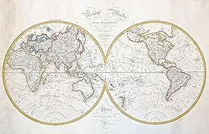
Mappe Monde en deux hemispheres.
Edité par Parigi, 1827
Vendeur : libreria antiquaria perini Sas di Perini, Verona, VR, Italie
Membre d'association : ALAI ILAB
Évaluation du vendeur 5 sur 5 étoiles
Art / Affiche / Gravure
EUR 780
Expédition ŕ EUR 40
Expédition depuis Italie vers Etats-UnisQuantité disponible : 1 disponible(s)
Ajouter au panierIncisione in rame, colorata, mm 530x810 (lastra). Mappamondo con le rotte di Cook e le nuove scoperte nell'emisfero australe. Complessivamente ben conservato e a pieni margini, anche se presenta traccia di qualche pieghetta e minimi difetti marginali. Nr.cat: P8190002.
-
Nouvel Atlas Portatif, Contenant La Géographie Universelle, Ancienne Et Moderne 1811 [Leather Bound]
Date d'édition : 2024
Vendeur : Gyan Books Pvt. Ltd., Delhi, Inde
Évaluation du vendeur 5 sur 5 étoiles
EUR 30,54
Livraison gratuite
Expédition depuis Inde vers Etats-UnisQuantité disponible : Plus de 20 disponibles
Ajouter au panierLeather Bound. Etat : New. Language: French. Presenting an Exquisite Leather-Bound Edition, expertly crafted with Original Natural Leather that gracefully adorns the spine and corners. The allure continues with Golden Leaf Printing that adds a touch of elegance, while Hand Embossing on the rounded spine lends an artistic flair. This masterpiece has been meticulously reprinted in 2024, utilizing the invaluable guidance of the original edition published many years ago in 1811. The contents of this book are presented in classic black and white. Its durability is ensured through a meticulous sewing binding technique, enhancing its longevity. Imprinted on top-tier quality paper. A team of professionals has expertly processed each page, delicately preserving its content without alteration. Due to the vintage nature of these books, every page has been manually restored for legibility. However, in certain instances, occasional blurriness, missing segments, or faint black spots might persist. We sincerely hope for your understanding of the challenges we faced with these books. Recognizing their significance for readers seeking insight into our historical treasure, we've diligently restored and reissued them. Our intention is to offer this valuable resource once again. We eagerly await your feedback, hoping that you'll find it appealing and will generously share your thoughts and recommendations. Lang: - French, Pages: - 284, Print on Demand. If it is a multi-volume set, then it is only a single volume. We are specialised in Customisation of books, if you wish to opt different color leather binding, you may contact us. This service is chargeable. Product Disclaimer: Kindly be informed that, owing to the inherent nature of leather as a natural material, minor discolorations or textural variations may be perceptible. Explore the FOLIO EDITION (12x19 Inches): Available Upon Request. 284.
-

Carte Generale de l'Asie, ou se trouvert les Decouvertes faites par Bougainville, Danpierre et la Perouse Dressee par Herisson
Date d'édition : 1810
Vendeur : Antique Print & Map Room, Ultimo, NSW, Australie
Membre d'association : ANZAAB ILAB
Évaluation du vendeur 4 sur 5 étoiles
Carte
EUR 1 207,87
Expédition ŕ EUR 31,66
Expédition depuis Australie vers Etats-UnisQuantité disponible : 1 disponible(s)
Ajouter au panierNo Binding. Etat : Good. Rare early edition (1810) of this wall chart of Asia by Eustache Herisson (1758-1818). Technique: Condition: Image size: 850mm x 1160mm (33.4" x 45.6") Paper size: 916mm x 1247mm (36" x 49").
-

Carte générale de l'Europe, ou l'on voit le départ et le retour du Capne. Cook, dans ses differéns voyages.
Vendeur : Douglas Stewart Fine Books, Armadale, VIC, Australie
Membre d'association : ANZAAB ILAB
Évaluation du vendeur 4 sur 5 étoiles
EUR 688,51
Expédition ŕ EUR 31,66
Expédition depuis Australie vers Etats-UnisQuantité disponible : 1 disponible(s)
Ajouter au panierDressée par Hérisson, Eleve de Mr. Bonne, ancien Ingénieur Hydrographe de la Marine. A Paris : chez Basset Md d'Estampes Rue Jacques au coin de celle des Mathurins, no. 670, 1802. Copperplate engraving, original outline hand colour, 525 x 755 mm (image), old folds as issued, a fine example. Map of Europe showing the departures and arrivals of Cook's three voyages. The National Library of Australia holds a 1795 edition of this map while an edition from 1812 is held in the State Library of New South Wales.


![Image du vendeur pour [Mapa] Carte d'Espagne et de Portugal ou se trouvent les grandes routes de postes mis en vente par Bolivar Old Prints Anticuario](https://pictures.abebooks.com/inventory/md/md32007398479.jpg)


![Image du vendeur pour Nouvel Atlas Portatif, Contenant La Géographie Universelle, Ancienne Et Moderne 1811 [Leather Bound] mis en vente par Gyan Books Pvt. Ltd.](https://pictures.abebooks.com/inventory/md/md31600279174.jpg)