Map java (14 résultats)

- Couverture rigide
- Édition originale
Vendeur : WONDERFUL BOOKS BY MAIL, CHICO-CA, CA, Etats-UnisWONDERFUL BOOKS BY MAIL
Contacter le vendeurVendeur avec une évaluation de 5 étoilesEtat: Occasion - Assez bon
EUR 10,86
EUR 3,30 expéditionExpédition nationale : Etats-UnisQuantité disponible : 1 disponible(s)
HARDCOVER. Etat : Very Good. Etat de la jaquette : Very Good. First Edition. VERY GOOD CONDITION IN VERY GOOD UNCLIPT(S27.50) DUST JACKET.CLEAN, SOLID,BRIGHT; gold titles on spine strip.rich brown hardcovers.MAP endpapers.TALL HARP dust cover art , dj flap has 2x3" photo of author & biog. ; 280+pg pages; BLACK COVERS.includes re…aders guide at back of book. .13579108642 pt line. .NICE, (UNCLIPT(S25.95) DUST JACKET. .GOLD TITLES ON deep blue spine.all nice, clean, solid copy. Illustrated by MICELI, JAVA Dj Art. Map Ep (illustrateur).
- Couverture rigide
- Édition originale
Vendeur : WONDERFUL BOOKS BY MAIL, CHICO-CA, CA, Etats-UnisWONDERFUL BOOKS BY MAIL
Contacter le vendeurVendeur avec une évaluation de 5 étoilesEtat: Occasion - Assez bon
EUR 13,58
EUR 3,30 expéditionExpédition nationale : Etats-UnisQuantité disponible : 1 disponible(s)
HARDCOVER. Etat : Very Good. Etat de la jaquette : Very Good. first edition,1p"; 13579108642pt line. VERY GOOD CONDITION IN VERY GOOD UNCLIPT(S27.95) DUST JACKET.CLEAN, SOLID,BRIGHT; gold titles on spine strip.rich brown hardcovers.MAP"KINGDOM OF DAVID" endpapers.TALL HARP embossed title to dust cover art , dj flap has 2x3" phot…o of author & biog. ; 302pg pages; BLACK COVERS.includes readers guide at back of book. .13579108642 pt line. .NICE, (UNCLIPT(S25.95) DUST JACKET. .GOLD TITLES ON deep blue spine.all nice, clean, solid copy. Illustrated by MICELI, JAVA Dj Art. Map Ep (illustrateur).

Map of Java - Showing Sectional View of Comparative Elevations of Principal Mountains - Antiquarian Coloured Map
MAP OF JAVA - ACCORDING TO VAN DE VELDE - an Original Antique Coloured Map
Langue : anglais
Vendeur : K Books Ltd ABA ILAB, York, YORKS, Royaume-UniK Books Ltd ABA ILAB
Contacter le vendeurVendeur avec une évaluation de 5 étoilesEtat: Occasion - Assez bon
EUR 24,04
EUR 22,76 expéditionExpédition depuis Royaume-Uni vers Etats-UnisQuantité disponible : 1 disponible(s)
No Binding. Etat : Very Good. An original antique map. Mounted and ready to frame. Hand coloured. In excellent condition, decorative and impressive.

Edité par [Encyclopedia Britannica] [circa1900]., [London and New York.], 1900
Vendeur : Asia Bookroom ANZAAB/ILAB, Canberra, ACT, AustralieAsia Bookroom ANZAAB/ILAB
Contacter le vendeurVendeur avec une évaluation de 5 étoilesEtat: Occasion
EUR 46,78
EUR 18,68 expéditionExpédition depuis Australie vers Etats-UnisQuantité disponible : 1 disponible(s)
Map in three insets, after W & AK Johnston, engravers with printed outline colour, 18.9 x 28.9 cm, central fold, paper age-toned, but in very good condition. Interesting map which first appeared in the ninth edition of Encyclopedia Britannica.

- Carte
Vendeur : Geographicus Rare Antique Maps, Brooklyn, NY, Etats-UnisGeographicus Rare Antique Maps
Contacter le vendeurVendeur avec une évaluation de 4 étoilesEtat: Occasion
EUR 253,47
EUR 14,94 expéditionExpédition nationale : Etats-UnisQuantité disponible : 1 disponible(s)
Very good. Slight toning and margin foxing. Size 11 x 13 Inches. This is Jeremiah Greenleaf's 1842 map of the East Indies and Southeast Asia. A Closer Look The map follows the 1835 David H. Burr map of the same region - and may well be the same plate, as we note few if any changes. Coverage embraces Southeast Asia and the East I…ndies, including Singapore, Sumatra, Java, Borneo, and the Philippines. On the mainland, it includes the Kingdoms of Siam (Thailand), Tonquin (North Vietnam), Cochinchina (South Vietnam), Malaya (Malaysia), Pegu (Burma), and Cambodia. Publication History and Census This map is the later Greenleaf issue of the David Hugh Burr / Illman map of 1835. The Burr map plates fell into the hands of Jeremiah Greenleaf, who revised them for publication in his own Universal Atlas . The present example is from the 1842 second Greenleaf edition of the atlas. References: Rumsey 15176.029.

Carte des Isles de Java, Sumatra, Borneo et les detroits de la Sonde Malaca et Banca Golphe de Siam.
1750 Bellin Map of the East Indies (Sumatra, Malay, Java, Borneo)
- Carte
Vendeur : Geographicus Rare Antique Maps, Brooklyn, NY, Etats-UnisGeographicus Rare Antique Maps
Contacter le vendeurVendeur avec une évaluation de 4 étoilesEtat: Occasion
EUR 278,82
EUR 14,94 expéditionExpédition nationale : Etats-UnisQuantité disponible : 1 disponible(s)
Very good. Even overall toning. Exhibits light offsetting. Blank on verso. Size 10.5 x 11.5 Inches. This is an attractive c.1780 Jacques Nicholas Bellin map of the East Indies. The map depicts from Siam (Thailand) and Tsiompa (modern day Vietnam) south to include the Sumatra, Java, and Borneo. The Malay Peninsula (Malacca), Sing…apore, Borneo, Sumatra, Java, and part of Celebes (Sulawesi), are included. Impressive detail appears along all the coastlines, however little inland information is present, as is common for Bellin's nautical charts. Singapore remains unidentified, but several other lesser islands are noted including Tioman Island (Poulo ou I. Timon) and Penang. A beautifully engraved rocco title cartouche adorns the lower left corner of the map. Publication History and Census This map was created by Jacques Nicholas Bellin and published in 1780 by De la Harpe in his Abrégé de l'Historie générale des Voyages . Four examples are cataloged in OCLC and are part of the institutional collections at Cornell University, the University of Hawaii, the Bayerische Staatsbibliothek in Munich, and the Unversitätsbibliothek München in Munich. References: OCLC 163338680.

Carte des Isles de Java, Sumatra, Borneo & les detroits de la Sonde Malaca et Banca Golphe de Siam.
1750 Bellin Map of the East Indies (Sumatra, Malay, Java, Borneo)
- Carte
Vendeur : Geographicus Rare Antique Maps, Brooklyn, NY, Etats-UnisGeographicus Rare Antique Maps
Contacter le vendeurVendeur avec une évaluation de 4 étoilesEtat: Occasion
EUR 278,82
EUR 14,94 expéditionExpédition nationale : Etats-UnisQuantité disponible : 1 disponible(s)
Very good. Minor wear along original fold lines. Minor spotting. Top margin extended. Size 10 x 12 Inches. This is an attractive c.1750 map of the East Indies by Jacques Nicholas Bellin. The map covers from Siam (Thailand) and Tsiompa (modern day Vietnam) south to include the Sumatra, Java, and Borneo. The Malay (Malacca), Singa…pore, Borneo, Sumatra, Java, and part of Celebes (Sulawesi), are also included. There is impressive detail throughout the coastline, with little inland information, as is common for Bellin's nautical charts. Singapore remains unidentified, but several other lesser islands are noted including Tioman Island (Poulo ou I. Timon) and Penang. A beautifully engraved rocco title cartouche adorns the lower left corner of the map. This map was issued in Antoine-Francois Prevost's Historie General des voyages . References: OCLC: 220972306.

- Carte
Vendeur : Geographicus Rare Antique Maps, Brooklyn, NY, Etats-UnisGeographicus Rare Antique Maps
Contacter le vendeurVendeur avec une évaluation de 4 étoilesEtat: Occasion
EUR 405,56
EUR 14,94 expéditionExpédition nationale : Etats-UnisQuantité disponible : 1 disponible(s)
Very good condition. Original centerfold exhibits minor toning. Blank on verso. Size 12 x 16.5 Inches. A beautiful example of Rigobert Bonne's 1771 decorative map the East Indies. Covers from the Gulf of Siam (Gulf of Thailand) and Malacca (Malaysia) eastward to include parts of Sumatra, Java, Borneo, the Celebes, parts of Cambo…dia, the southern Philippine Islands, and New Guinea. Offers considerable detail of the region. Notes the Straight of Singapore (Det. de Sin Capura) and shows but does not label the island of Singapore. In Borneo, this map provides good detail along the Banjermassin or Barito River, detailing numerous villages and trading stations. Names Bali and Lombok as well as Batavia. Several of the southern islands are drawn with their southern shores ghosted in - suggesting an uncertain coastline. This is also the case with much of New Guinea (Nouvelle Guinee), which was largely unexplored well into the 19th century. Rhumb lines throughout. Arrows in the lower right show the direction of prevailing winds during the dry season and the monsoon season. A fine map of the region. Drawn by R. Bonne in 1771 for issue as plate no. D 26 in Jean Lattre's 1776 issue of the Atlas Moderne . References: Rumsey 2612.056. Phillips (Atlases) 664. National Maritime Museum, 215.

- Carte
Vendeur : Geographicus Rare Antique Maps, Brooklyn, NY, Etats-UnisGeographicus Rare Antique Maps
Contacter le vendeurVendeur avec une évaluation de 4 étoilesEtat: Occasion
EUR 456,25
EUR 14,94 expéditionExpédition nationale : Etats-UnisQuantité disponible : 1 disponible(s)
Very good. Minor wear along original fold lines. Minor wear and verso repair near right bottom margin. Narrow bottom right margin. Original platemark visible. Size 18.5 x 11 Inches. This is a rare and exquisite 1726 map of eastern Java by Francois Valentijn. It covers the eastern tip of Java as well as the western portions of Ba…li including the modern day Bondowosa Regency, Situbondo Regency, Jember Regency and the Banyuwangi Regency including Blambangan Peninsula and the Bali Strait. The map offers beautiful engraving and extraordinary detail throughout, noting rice plantations, mountain ranges, forests, rivers and a host of additional topographical features. The previously unknown southern shore is mapped both correctly and in considerable detail. Offshore reefs, soundings and coastal features are also shown. The Dutch were active in this region since the 17th century and had no doubt produced accurate manuscript charts of the Island, but these were carefully guarded trade secrets controlled by the powerful Vereenigde Oostindische Compagnie (V.O.C. or Dutch East India Company). The VOC's policy of extreme secrecy, especially regarding cartographic matters, historically limited publication of their charts. As a VOC officer, Valentijn doubtless had access to VOC manuscript records which he complied into his remarkable collection of maps. Valentijn's maps are so superior to previous maps that their publication itself is rather surprising, making this particular map an extremely rare find. A highly important map of the region and a must for a serious collection focusing on the East Indies. Prepared by Francois Valentijn for inclusion in his eight volume five part masterwork Oud en Nieuw Oost-Indien .

- Carte
Vendeur : Geographicus Rare Antique Maps, Brooklyn, NY, Etats-UnisGeographicus Rare Antique Maps
Contacter le vendeurVendeur avec une évaluation de 4 étoilesEtat: Occasion
EUR 5 069,50
EUR 14,94 expéditionExpédition nationale : Etats-UnisQuantité disponible : 1 disponible(s)
Very good. Slight margin foxing and soiling. Size 26.5 x 39 Inches. This is a striking 1835 Heinrich Berghaus map of Java, the Sunda Strait, Bali, Lombok, South Borneo, and Celebes. The map illustrates the heart of the Dutch East Indies at the height of its colonial significance. It was issued for Berghaus' looseleaf Atlas von A…sien , the best-informed general cartographic work on Asia to appear in the mid-19th century. A Closer Look Coverage embraces the wide and then little-known region surrounding the Java Sea but focuses most detail on Java, Bali, and Lombok. With land profiles, copious depth soundings, and nautical annotations, it serves well as both a nautical chart and a terrestrial map. The polities in Java, Bali, and Lombok are broken out between Dutch-controlled Java, administered from Batavia, and local Sultanates - particularly south-central Java, which defied Dutch colonial control until 1862. There are six insets, one detailing the VOC administrative center of Batavia (Jakarta), a cluster detailing the Gaspar, Assas, and Sapy Straits. A final large inset details the Sunda Strait, the most critical access point to the Java Sea and points north, making it an essential transit point for the Dutch East India trade. Of note, this inset map prominently includes the island of Krakatoa (Cracatoa), then home to hundreds of villages. Two-thirds of the island was obliterated in an 1883 volcanic eruption, one of the largest in recorded history. The Dutch East Indies In the 1830s, the Dutch East Indies comprised most of Java, Sumatra, and the Moluccas. The Dutch government, having dissolved the Dutch East India Company (VOC) by 1799, administered the colony directly with a focus on economic exploitation. Plantation agriculture, including cash crops such as sugar and coffee, was promoted, often with institutionalized forced labor. Infrastructure development, such as roads and ports, facilitated the transportation of goods. Indigenous resistance to Dutch control persisted, leading to local uprisings and conflicts throughout the 1830s, most of which ended with expanded Dutch control. Persistent resistance to Dutch exploitation persisted until the 1940s, when, after a prolonged struggle for independence, Indonesian sovereignty was recognized in 1949. Publication History and Census This map was published in 1835 by Heinrich Berghaus and Justus Perthes. It was engraved in Berlin by Wilhelm Jätting. The map is no. 17 of Berghaus' Atlas von Asien , all the individual maps of which are exceedingly desirable. We know of examples in the David Rumsey Collection, the Bibliothèque nationale de France, and numerous German collections, but there is little to no presence on the private market. References: Rumsey 15177.007.

Java-China Japan Lyn. / Map Showing Routes Ports of Call and services of the java-China Japan Line.
1939 Stanford Map of East Asia: Java-China Japan Steamship Line
- Carte
Vendeur : Geographicus Rare Antique Maps, Brooklyn, NY, Etats-UnisGeographicus Rare Antique Maps
Contacter le vendeurVendeur avec une évaluation de 4 étoilesEtat: Occasion
EUR 1 825,02
EUR 14,94 expéditionExpédition nationale : Etats-UnisQuantité disponible : 1 disponible(s)
Good to very good. Laid on original linen. Old varnish yielding a warm tone. Tear from top edge extending about 5 inches into the map, stabilized by older repair on verso. Creasing along edge and in margin, especially at top. Size 43.5 x 34 Inches. A dramatic large-scale c. 1939 Edward Stanford map promoting the Java-China Japan… (JCJL) steamship line (??????????). It serves as a reminder of the interconnections throughout East Asia that persisted despite the geopolitical tensions in the 1930s. A Closer Look Coverage extends from Mongolia to Java and northern Australia and from Burma to New Guinea, embracing China, Japan, Taiwan, Southeast Asia, the East Indies, and the Philippines. Blue lines trace the routes of the JCJL through the Yellow, China, and Java Seas, while a darker line at the top indicates the Trans-Siberian and China Eastern Railways. A table of distances between major ports is provided at the bottom left. Five scales and a brief legend indicating rail and telegraph lines appear on the right. Java-China Japan Line The Java-China Japan Line was a Dutch shipping and passenger line in East and Southeast Asia founded in 1902 by Ernst Heldring (1871 - 1954). Heldring was also the founder of several other shipping companies serving the East Indies inter-island trade, including Koninklijke Paketvaart Maatschappij (KPM), Stoomvaart Maatschappij Nederland (SMN) and Rotterdamsche Lloyd (RL). The firm maintained regular services, as illustrated here, between China, Japan, Korea, the Philippines, the East Indies, and French Indochina, despite increasing tensions between Japan and other countries, especially China, which resulted in a full-scale war by 1937. Under various names, it remained operational until 1970, when it merged with several other firms to form Nedlloyd. Java Road in Hong Kong is named after the line, which had its headquarters there in the early 20th century. Publication History and Census This map was produced in London by Edward Stanford's Geographical Establishment - the premier mapmaker in early 20th-century London. It likely went through many iterations, of which we can find no clear breakdown. Based on the shipping routes, we estimate this map to have been issued in the 1930s. The presence of Manchukuo indicates a date of 1933 or later, while Sikang (Xikang) Province in China suggests a date in the very late 1930s. However, Beijing retains the name Peiping (Beiping), and no reference is made to the Second Sino-Japanese War (1937 - 1945), which drastically upset these shipping routes, suggesting that the map was produced in the early stages of the conflict. An example is part of the David Rumsey Map Collection. We also note examples cataloged in OCLC as part of the collections at Vrije Universiteit Amsterdam, Leiden University, and the University of Michigan, cataloged with various dates. References: Rumsey 10733.003. OCLC 67526940, 71570583, 238760864.
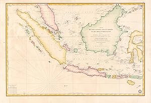
Carte des Iles Sumatra, Java et Borneo et des mers Environnantes.
1839 Depot de la Marine Map of the East Indies: Malay, Singapore, Java, Sumatra, Borneo
- Carte
Vendeur : Geographicus Rare Antique Maps, Brooklyn, NY, Etats-UnisGeographicus Rare Antique Maps
Contacter le vendeurVendeur avec une évaluation de 4 étoilesEtat: Occasion
EUR 1 013,90
EUR 14,94 expéditionExpédition nationale : Etats-UnisQuantité disponible : 1 disponible(s)
Very good. Slight wear. Some creases and spots of discoloration in the margins. Faded annotations in top-left portion of the map. Size 23 x 34.5 Inches. A beautiful and rare 1839 French Depot-General de la Marine nautical chart or maritime map of the East Indies or Insular Southeast Asia - including Singapore. The size and level… of detail is impressive, reflecting the importance of the chart as representing the pinnacle of hydrographical knowledge at the time. A Closer Look Based upon the work of the British hydrographer James Horsburgh, namely his groundbreaking work Directions for sailing to and from the East Indies, China, New Holland, Cape of Good Hope, and the interjacent ports , this elegantly hand-colored map covers Sumatra, Java, and Borneo in full, as well as Malay (Malacca) south of Lancava and parts of the Celebes. It further specifically includes the islands of Singapore (Sincapoor), Bali (Bally), Lombok (Lombock), Krakatoa (Crockatoa), and Komodo (Comodo). Soundings, anchorages, shoals, hazards, and supplementary information on currents, longitude, latitude, and more are indicated. Soundings are measures in brasses , a French unit popular at the time roughly similar to a fathom; a table of conversion to meters is provided at bottom-left. Islands, coastal settlements, and other landward features are noted in fantastic detail. Publication History and Census This chart was prepared by Pierre Daussy in 1839 based on the hydrography of James Horsburgh, engraved by Chassant (no given name known), with text by Jacques-Marie Hacq, under the direction of the Dépôt-général de la Marine. The map was reissued several times through the 1880s with updates and additions, but the date of 1839 and other identifying information (such as 'No. 889' in the top-right corner) remained, leading to a high degree of variation in cataloging which makes a comprehensive census difficult. This edition, presumably the first as it is the least accurate, differs from more widely available examples in several respects, such as the representation of Singapore and the small islands south of Celebes. Nevertheless, in any edition this chart is quite rare, especially with such exquisite hand-coloring. References: OCLC 888127755, 902603727.

Partie de L'ile Sumatra. Oceanique no. 19.
1827 Vandermaelen Map of Sumatra, the Sunda Strait, and the Java Sea
- Carte
Vendeur : Geographicus Rare Antique Maps, Brooklyn, NY, Etats-UnisGeographicus Rare Antique Maps
Contacter le vendeurVendeur avec une évaluation de 4 étoilesEtat: Occasion
EUR 760,42
EUR 14,94 expéditionExpédition nationale : Etats-UnisQuantité disponible : 1 disponible(s)
Very good. Size 15.75 x 20.25 Inches. This is 1827 Vandermaelen map of Sumatra's east coast, the Caremata Straits, the Sunda Strait, and the western part of the Java Sea. It is the first map of the region produced by lithography. The map extends as far as the southwest coast of Borneo, and also shows the Bangka Belitung Islands,… and the island of Belitung. The coast of Java only appears in the form of the mountainous peninsula north of Cilegon. The scattered, tiny islands north of Jakarta appear here as a largely imaginary archipelago labeled 'Les Milles Iles.' Colonialism in Palembang The map shows an area hotly contested by the British and the Dutch. The region had been the sphere of influence of the Sultanate of Palembang until the British sacked the city and installed a pro-England sultan in 1812; the Dutch subsequently took Palembang in 1821. abolishing the Sultanate in 1825. Under the Dutch, Palembang became the capital of the Residency of Palembang, which would after independence became South Sumatra. At the time this map was printed, the Dutch were introducing new export crops (coffee in particular.) Belitung and Bangka Belitung The islands of Belitung (here using its English spelling, Billiton) and Bangka are shown; these were ceded to the British in 1812, and passed to the Dutch in 1814. A fort is shown at Toboali (Toubouali) in the area where a Dutch fort was constructed in 1825. At the time, it was known for its pepper, and as early as the late 18th century was being extensively mined for tin. Mines appear on Banka in the northern and western administrative divisions. This island shows much more detail than the other regions, offering reasonably up-to-date information, perhaps a reflection on the importance of its resources - which represent a point of contention to this day, as Bangka is the world's second largest producer of tin (narrowly edged out by China) to the detriment of its environment. Publication History This map appeared in the sixth part, 'Océanique,' of Vandermaelen's Atlas universel de géographie physique, politique, statistique et minéralogique. The atlas was produced in one edition in 1827; only 810 complete sets were sold. The full set of six volumes appears in eleven institutional collections in OCLC; the 6th volume alone is listed in 10. This map is listed as a separate only in the collection of the National Library of Australia. References: OCLC 225098855.

A New Chart of the North Coast of Java, wherein are described The Roads of Bantam and Batavia, from the Manuscript Draught of the Dutch East India Company.
1794 Laurie and Whittle Nautical Map of the Northwest Java (Jakarta), Indonesia
- Carte
Vendeur : Geographicus Rare Antique Maps, Brooklyn, NY, Etats-UnisGeographicus Rare Antique Maps
Contacter le vendeurVendeur avec une évaluation de 4 étoilesEtat: Occasion
EUR 1 216,68
EUR 14,94 expéditionExpédition nationale : Etats-UnisQuantité disponible : 1 disponible(s)
Very good. Minor wear and verso repair along original centerfold. Original platemark visible. Some offsetting. Size 23 x 35 Inches. This is a fine example of Laurie and Whittle's 1794 nautical chart or maritime map of northwestern Java. The map covers from Bantam Bay (Selat Sunda) and Hill (Serang, Indonesia) eastwards as far as… Batavia (Jakarta, Indonesia). This region was a major battleground between rival Dutch, British, and Portugese trading monopolies. The Dutch and British in particular contested over northwestern Java, with its easy access to regional spice, in particular pepper, ports. In 1602 the British East India Company established a trade entrepot at Bantam to contest Dutch East India Company (VOC) control based in nearby Batavia. The Dutch, allied with a local Sultan, eventually drove the English out Bantam and Java itself. By the end of the 18th century, when this map was made, the Bantam entrepot was little more than a name on a map - as seen here - while Batavia further east had risen, with a population of nearly one million, to dominate Java. In 1800, just six years after this map was published, the VOC was formally dissolved and the Dutch East Indies established in its place as a full-fledged national colonial venture. The British meanwhile established themselves in Bencoolen, on Sumatra, and later in Singapore and Malacca. Laurie and Whittle prepared this chart for their 1799 issue of the East-India Pilot . Though most charts in the East-India Pilot were derived from earlier maps prepared for Jean-Baptiste d'Apres de Mannevillette's 1745 Neptune Oriental , this particular chart is a new production unique to Laurie and Whittle. The map offers rich detail including countless depth soundings, notes on the sea floor, commentary on reefs, rhumb lines, shoals, place names and a wealth of other practical information for the mariner. This chart is cartographically derived from earlier manuscript maps prepared by the Dutch East India Company (VOC) and later corrected and improved from an English draft prepared by Captain Henry Smedley. This map was registered by Laurie and Whittle from their offices at 53 Fleet Street, London, on May 12, 1794.


