Montant total (1 article articles) :
Destination de la commande :

metellus j (4 rťsultats)
Commentaires
Passer aux rťsultats principaux de la recherche
Filtres de recherche
Type d'article
- Tous les types de produits
- Livres (3)
- Magazines & Pťriodiques (Aucun autre rťsultat ne correspond ŗ ces critŤres)
- Bandes dessinťes (Aucun autre rťsultat ne correspond ŗ ces critŤres)
- Partitions de musique (Aucun autre rťsultat ne correspond ŗ ces critŤres)
- Art, Affiches et Gravures (1)
- Photographies (Aucun autre rťsultat ne correspond ŗ ces critŤres)
- Cartes (Aucun autre rťsultat ne correspond ŗ ces critŤres)
- Manuscrits & Papiers anciens (Aucun autre rťsultat ne correspond ŗ ces critŤres)
Etat En savoir plus
- Neuf (Aucun autre rťsultat ne correspond ŗ ces critŤres)
- Comme neuf, TrŤs bon ou Bon (2)
- Assez bon ou satisfaisant (Aucun autre rťsultat ne correspond ŗ ces critŤres)
- Moyen ou mauvais (Aucun autre rťsultat ne correspond ŗ ces critŤres)
- Conformťment ŗ la description (2)
Reliure
- Toutes
- Couverture rigide (Aucun autre rťsultat ne correspond ŗ ces critŤres)
- Couverture souple (2)
Particularitťs
- Ed. originale (Aucun autre rťsultat ne correspond ŗ ces critŤres)
- Signť (Aucun autre rťsultat ne correspond ŗ ces critŤres)
- Jaquette (Aucun autre rťsultat ne correspond ŗ ces critŤres)
- Avec images (3)
- Sans impressions ŗ la demande (4)
Langue (2)
Livraison gratuite
Pays
Evaluation du vendeur
-
Softcover. Etat : Bon. Petite(s) trace(s) de pliure sur la couverture. Tampon ou marque sur la face intťrieure de la couverture. Ammareal reverse jusqu'ŗ 15% du prix net de cet article ŗ des organisations caritatives. ENGLISH DESCRIPTION Book Condition: Used, Good. Slightly creased cover. Stamp or mark on the inside cover page. Ammareal gives back up to 15% of this item's net price to charity organizations.
-

A savoir en geriatrie - Collection L'actualitť en Gťrontologie
Editť par SANDOZ, 1981
Vendeur : Le-Livre, SABLONS, France
Membre d'association : ILAB
…valuation du vendeur 5 sur 5 ťtoiles

EUR 20,90
Autre deviseEUR 6 expťdition vers FranceQuantitť disponible : 1 disponible(s)
Ajouter au panierCouverture souple. Etat : bon. RO20264581: 1981. In-8. Brochť. Etat d'usage, Couv. convenable, Dos satisfaisant, Intťrieur frais. 55 pages. Nombreuses photographies en noir et blanc, dans le texte. . . . Classification Dewey : 610-Sciences mťdicales. Mťdecine.
-

Sardinia
Editť par Colonia, 1601
Vendeur : libreria antiquaria perini Sas di Perini, Verona, VR, Italie
Membre d'association : ALAI ILAB
…valuation du vendeur 5 sur 5 ťtoiles
Art / Affiche / Gravure
EUR 1†900
Autre deviseGratuit expťdition depuis Italie vers FranceQuantitť disponible : 1 disponible(s)
Ajouter au panierIncisione in rame, mm 180x260. Rarissima carta tratta dalla rarissima opera "Insularium Orbis aliquot insularum÷" in cui solo 4 carte sono a doppia pagina, fra cui la Sardegna (Meurer pag. 190), opera edita dalla cosidetta Scuola di Colonia (1570-1620 ca.), costituita da incisiore e cartografi fiamminghi ed olandesi rifugiatisi a Colonia per sfuggire alle lotte religiose di fine secolo. Spiccano Matthaeus Quad e Frans Hogenberg, che ne fu il fondatore. Jan Matal o Metellus, francese di nascita fu tra i maggiori cartografi del tempo e, insieme al Quad e al Hogenberg stesso, il principale esponente della scuola coloniese. Le sue carte sono poi incluse in pubblicazioni postume (come la nostra), e recano il testo al verso. Esse sono basate sulle carte pubblicate ad Anversa da Abraham Ortelius, per la prima volta nel 1570; le incisioni delle mappe sono invece attribuite a Frans Hogenberg. Di grandissima rarit? Bell'esemplare con lieve ingiallimento dellla carta. Meurer, Atlantes Colonienses, MET 10. Nr.cat: P5202043.
-
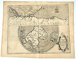
Chica Sive Patagonia et Australis Terra
Editť par Cologne, 1598
Vendeur : Antipodean Books, Maps & Prints, ABAA, Garrison, NY, Etats-Unis
Membre d'association : ABAA ANZAAB ESA ILAB
…valuation du vendeur 5 sur 5 ťtoiles
EUR 3†363,73
Autre deviseEUR 30,32 expťdition depuis Etats-Unis vers FranceQuantitť disponible : 1 disponible(s)
Ajouter au panierExtremely rare and early map of the Southern Hemisphere that attempts to define the assumed Great South land mass, including today's Australia, Antarctica, Indonesia, South Africa & Argentina. The top of the map has an interesting Mercator projection of Patagonia achingly close to a large land mass "Terrae Australis Pars". C. Della Victoria and the illustration of Magellan's ship the Victoria bears witness to his discovery of the strait that now bears his name. Below is a polar projection of a great south land entitled "Terra Australis". Within the Antarctic Circle, termed "Terra Incognitia" is an array of mountains and 3 large named rivers. Part of the coast (actually the north coast of Australia) is marked with Marco Polo's kingdoms of Beach, Lucach and Maletur. This is a German re-engraving of the Wytfliet Map dated 1597 (Spence 3010), but is much rare than it (see discussion below). German text on the verso with the header "Chica" above one page. The Quad map of a year later (Spence 3011) included the addition of "Fretum Magellanicum" at the Straights. (see Tooley plt 102). Oddly, the Metellus is not in Spence, but should be between 3010 and 3011. See Schilder fig. 6 for the Wyfliet map. Copper engraving, 22 x 28.5 cms. "Wytfliet and Metellus produced the first separate printed maps of the Southern Hemisphere. Both are foundation maps of America and Australia. The Wytfliet is known to have been produced in 1597, the Metellus, which is much rarer and seldom available on the market, is usually dated 1598 but some scholars have argued the possibility that it may precede the Wytfliet. The Metellus is acknowledged as, by far, the finer engraving of the two, which, along with its rarity and importance, makes it a focal point of any collection of early American and Australian maps." (After Casten). "As with the Cornelis Wytfliet a year earlier this publication contained a set of maps relating to the Americas only. All but one are derived from the Wytfliet. These were used to illustrate the German edition of Josť de Acosta's 'De Natura Nova Orbis', first published in Salamanca, 1588. Acosta was a Spanish Jesuit missionary, historian and cosmographer. The maps, however, are attributed to Johannes Matalius Metellus (Jean Matal in his native French), a very well respected geographer of his day. In the 'America sive Novus Orbis' of 1600, he is named as the cartographer of the maps but, most probably, did not see their completion as he died in 1597. The work was finished by a friend, Meurer identifies him as Conrad Loew, a pseudonym for Matthias Quad. Born in Burgundy, 1520, Metellus spent much of his working life in Louvain where, of course, the Wytfliet atlas was published. However, he spent his last years in Cologne, dying in 1597. This leads us to the possibility thet the Metellus actually pre-dates the Wytfliet as the first atlas concentrating on America. A number of questions are posed. Is there an earlier edition still unknown, as all issues are extremely rare ? Is Metellus the true author of the Wytfliet maps? All issues have text on the back, and are extremely rare." (Burden on the Conibas map) Only a handful examples of the Metellus books are known, see Burden 115 for a list of locations.