Montant total (1 article articles) :
Destination de la commande :

Cartes, egypte ancienne (40 résultats)
Commentaires
Passer aux résultats principaux de la recherche
Filtres de recherche
Type d'article
- Tous les types de produits
- Livres (6 681)
- Magazines & Périodiques (37)
- Bandes dessinées (2)
- Partitions de musique (Aucun autre résultat ne correspond ŕ ces critčres)
- Art, Affiches et Gravures (390)
- Photographies (39)
- Cartes (40)
- Manuscrits & Papiers anciens (1 499)
Etat En savoir plus
- Neuf (Aucun autre résultat ne correspond ŕ ces critčres)
- Comme neuf, Trčs bon ou Bon (12)
- Assez bon ou satisfaisant (7)
- Moyen ou mauvais (Aucun autre résultat ne correspond ŕ ces critčres)
- Conformément ŕ la description (21)
Particularités
- Ed. originale (1)
- Signé (Aucun autre résultat ne correspond ŕ ces critčres)
- Jaquette (1)
- Avec images (37)
- Sans impressions ŕ la demande (40)
Langue (3)
Livraison gratuite
- Livraison gratuite ŕ destination de France (Aucun autre résultat ne correspond ŕ ces critčres)
Pays
Evaluation du vendeur
-
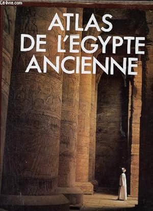
Atlas de l'Egypte ancienne.
Vendeur : Le-Livre, SABLONS, France
Membre d'association : ILAB
Évaluation du vendeur 5 sur 5 étoiles

Carte
EUR 20,90
Autre deviseEUR 6 expédition vers FranceQuantité disponible : 1 disponible(s)
Ajouter au panierCouverture rigide. Etat : bon. R320144619: 1986. In-4. Relié. Bon état, Couv. convenable, Dos satisfaisant, Intérieur frais. 240 pages - jaquette en bon état - nombreuses illustrations en couleurs et en noir et blanc dans et hors texte - quelques cartes en couleurs dans et hors texte. Avec Jaquette. . . Classification Dewey : 912-Atlas, cartes et plans.
-
CARTE ANCIENNE EGYPTE ANCIENNE 1835 MONIN FREMIN BENARD ACIER OLD MAP F09
Edité par Binet, Paris, 1835
Langue: français
Vendeur : Librairie RAIMOND, Dourges, France
Évaluation du vendeur 5 sur 5 étoiles
Carte
EUR 15
Autre deviseEUR 6,50 expédition vers FranceQuantité disponible : 1 disponible(s)
Ajouter au panierPas de couverture. Etat : Bon. CARTE ANCIENNE EGYPTE ANCIENNE 1835 Dressée par MONIN & FREMIN, gravée sur acier par BENARD, éditée par BINET ŕ Paris (Carte authentique du XIXe sičcle-original map) Dimensions de la feuille : 31 x 25 cm environ Dimensions de la carte au coup de planche : 24,5 x 19 cm environ Etat : belle carte (ref-F09).
-
Egypte ancienne. (Carte dressée en 1833).
Edité par Chez Félix Delamarch, Paris., 1834
Vendeur : Librairie Et Cćtera (et caetera) - Sophie Rosičre, Belin-Béliet, France
Évaluation du vendeur 5 sur 5 étoiles
Carte
EUR 12
Autre deviseEUR 5,40 expédition vers FranceQuantité disponible : 1 disponible(s)
Ajouter au panierCarte en français. Carte extraite de l'Atlas de la géographie ancienne, du moyen âge, et moderne. Carte 34 x 48 cm. Pliée en deux. Cartes géographiques. Carte.
-
CARTE ANCIENNE EGYPTE NUBIE ABYSSINIE 1835 MONIN FREMIN BENARD ACIER OLD MAP F37
Edité par Binet, Paris, 1835
Langue: français
Vendeur : Librairie RAIMOND, Dourges, France
Évaluation du vendeur 5 sur 5 étoiles
Carte
EUR 20
Autre deviseEUR 6,50 expédition vers FranceQuantité disponible : 1 disponible(s)
Ajouter au panierPas de couverture. Etat : Bon. CARTE ANCIENNE EGYPTE NUBIE ABYSSINIE 1835 Dressée par MONIN & FREMIN, gravée sur acier par BENARD, éditée par BINET ŕ Paris (Carte authentique du XIXe sičcle-original map) Dimensions de la feuille : 31 x 25 cm environ Dimensions de la carte au coup de planche : 24,5 x 19 cm environ Etat : belle carte (ref-F37).
-

"Egypte ancienne" - Egypt Egypte Ägypten
Edité par Paris, 1834
Langue: français
Vendeur : Antiquariat Steffen Völkel GmbH, Seubersdorf, Allemagne
Membre d'association : ILAB VDA
Évaluation du vendeur 5 sur 5 étoiles
Carte
EUR 9,99
Autre deviseEUR 19,70 expédition depuis Allemagne vers FranceQuantité disponible : 1 disponible(s)
Ajouter au panierSeltene handkolorierte lithographische Karte von ca. 1834. -- Blatt-Maße: ca. 19,7 x 23,3 cm. -- gut erhalten. || Rare hand colored lithographic map from circa 1834. -- in very good condition. || Dies ist ein Original! - Kein Nachdruck! - Keine Kopie! -- This is an original! - No copy! - No reprint! Sprache: Französisch Gewicht in Gramm: 550.
-

Egypte Ancienne, Arabie Pétrée et Pays de Chanaan. Planche 4
Edité par HACHETTE, 1863
Vendeur : Le-Livre, SABLONS, France
Membre d'association : ILAB
Évaluation du vendeur 5 sur 5 étoiles
Carte
EUR 16,95
Autre deviseEUR 6 expédition vers FranceQuantité disponible : 1 disponible(s)
Ajouter au panierPas de couverture. Etat : bon. RO20031952: 1863. In-4. En feuillets. Bon état, Couv. convenable, Dos satisfaisant, Intérieur frais. Carte couleur sur planche. . . . Classification Dewey : 912-Atlas, cartes et plans.
-
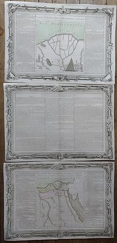
MONDE CONNU DES ANCIENS - EGYPTE ANCIENNE - TEMPS PRIMITIFS - SYSTEME GEOGRAPHIQUE D'ERATHOSTHENES
Edité par LIBRAIRIE CLASSIQUE D'EUGENE BELIN NON DATE
Vendeur : Le-Livre, SABLONS, France
Membre d'association : ILAB
Évaluation du vendeur 5 sur 5 étoiles
Carte
EUR 35,80
Autre deviseEUR 6 expédition vers FranceQuantité disponible : 1 disponible(s)
Ajouter au panierCouverture souple. Etat : bon. RO30115873: NON DATE. In-Plano. Broché. Etat d'usage, Livré sans Couverture, Dos satisfaisant, Intérieur acceptable. Carte originale 45x30 cm en couleurs. . . . Classification Dewey : 912-Atlas, cartes et plans.
-

Carte de l'Egypte Ancienne
Edité par FAYARD, 1877
Vendeur : Le-Livre, SABLONS, France
Membre d'association : ILAB
Évaluation du vendeur 5 sur 5 étoiles
Carte
EUR 30,90
Autre deviseEUR 6 expédition vers FranceQuantité disponible : 2 disponible(s)
Ajouter au panierPas de couverture. Etat : bon. RO20039112: 1877. In-4. En feuillets. Etat d'usage, Livré sans Couverture, Dos satisfaisant, Intérieur bon état. Carte en couleurs. . . . Classification Dewey : 912-Atlas, cartes et plans.
-

Atlas moderne ou collection de cartes sur toutes les parties du globe terrestre carte de l'Egypte ancienne et moderne
Edité par Laporte, 1777
Vendeur : Le-Livre, SABLONS, France
Membre d'association : ILAB
Évaluation du vendeur 5 sur 5 étoiles
Carte
EUR 35,80
Autre deviseEUR 6 expédition vers FranceQuantité disponible : 1 disponible(s)
Ajouter au panierPas de couverture. Etat : bon. RO20020339: 1777. In-12. En feuillets. Bon état, Couv. convenable, Dos satisfaisant, Intérieur frais. Carte, noir et blanc, sur papier ŕ la forme, échelle"stades d'Egypte de 533 au degré". . . . Classification Dewey : 912-Atlas, cartes et plans.
-

"Carte de L'Egypte Ancienne et Moderne Dressee sur plusieurs Cartes Manuscrites. " - Egypt Ägypten Africa Afrika carte map Karte
Edité par Paris, 1762
Langue: français
Vendeur : Antiquariat Steffen Völkel GmbH, Seubersdorf, Allemagne
Membre d'association : ILAB VDA
Évaluation du vendeur 5 sur 5 étoiles
Carte
EUR 39,99
Autre deviseEUR 19,70 expédition depuis Allemagne vers FranceQuantité disponible : 1 disponible(s)
Ajouter au panierOriginal handkolorierte Kupferstich-Karte von 1762. -- Blattmasse: ca. 54 cm x 37 cm. -- gut erhalten. || -- Original hand-colored engraved map from 1762. -- in very good condition. ! Sprache: Französisch Gewicht in Gramm: 1550.
-

"Carte de l'Egypte Ancienne et Moderne." - Egypt Ägypten Nile Nil Africa Afrika Afrique
Edité par Venezia, Santini & Remondini, 1779
Langue: français
Vendeur : Antiquariat Steffen Völkel GmbH, Seubersdorf, Allemagne
Membre d'association : ILAB VDA
Évaluation du vendeur 5 sur 5 étoiles
Carte
EUR 79,99
Autre deviseEUR 19,70 expédition depuis Allemagne vers FranceQuantité disponible : 1 disponible(s)
Ajouter au panierGroßformatige altkolorierte Kupferstich-Karte von 1779. Auf starkem Papier gedruckt. -- Blatt-Maße: ca. 52 x 74 cm. -- mit schwacher Knickspur, sonst gut erhalten. || Large old colored engraved map from 1779. Printed on strong paper. -- in good condition. || Francesco Santini was a Venetian publisher. He acquired the printing plates of Vaugondy's Atlas Universel, a commercial and cartographic success, with widespread influence on mapmakers throughout Europe. Together with his brother Paolo, he commissioned a new set of plates and reissued the atlas in 1776. In the following years, Paolo Santini assigned all his publication rights to M. Remondini, who in 1777 reissued the same atlas, but with his name. Sprache: Französisch Gewicht in Gramm: 550.
-
Egypte Ancienne [Ancient Egypt]
Date d'édition : 1871
Vendeur : Antiqua Print Gallery, London, Royaume-Uni
Évaluation du vendeur 3 sur 5 étoiles

Carte
EUR 37,81
Autre deviseEUR 12,62 expédition depuis Royaume-Uni vers FranceQuantité disponible : 1 disponible(s)
Ajouter au panierEtat : Good. Egypte Ancienne. Ancient Egypt. MALTE-BRUN c1871 old antique map plan chart. Antique 19th century engraved atlas map with original colour; P Bellier Impr. Pierre Sarrazin (c1871). 32.0 x 24.5cm, 12.5 x 9.5 inches. Condition: Good. Blemish in margin. There is nothing printed on the reverse side, which is plain.
-
"Carte de l'Egypte Ancienne et Moderne." - Egypt Ägypten Nile Nil Africa Afrika Afrique
Edité par Venezia, Santini & Remondini, 1779
Langue: français
Vendeur : Antiquariat Steffen Völkel GmbH, Seubersdorf, Allemagne
Membre d'association : ILAB VDA
Évaluation du vendeur 5 sur 5 étoiles
Carte
EUR 89,99
Autre deviseEUR 19,70 expédition depuis Allemagne vers FranceQuantité disponible : 1 disponible(s)
Ajouter au panierGroßformatige altkolorierte Kupferstich-Karte von 1779. Auf starkem Papier gedruckt. -- Blatt-Maße: ca. 52 x 74 cm. -- nur im Außenrand leicht fleckig, sonst sehr gut erhalten. || Large old colored engraved map from 1779. Printed on strong paper. -- slightly stained only on the outer margin, otherwise in very good condition. || Francesco Santini was a Venetian publisher. He acquired the printing plates of Vaugondy's Atlas Universel, a commercial and cartographic success, with widespread influence on mapmakers throughout Europe. Together with his brother Paolo, he commissioned a new set of plates and reissued the atlas in 1776. In the following years, Paolo Santini assigned all his publication rights to M. Remondini, who in 1777 reissued the same atlas, but with his name. Sprache: Französisch Gewicht in Gramm: 550.
-

"Carte de l'Egypte ancienne et moderne" - Egypt Ägypten Kairo Cairo Alexandria Afrique Africa Afrika
Edité par Paris, 1753
Langue: français
Vendeur : Antiquariat Steffen Völkel GmbH, Seubersdorf, Allemagne
Membre d'association : ILAB VDA
Évaluation du vendeur 5 sur 5 étoiles
Carte
EUR 99,99
Autre deviseEUR 19,70 expédition depuis Allemagne vers FranceQuantité disponible : 1 disponible(s)
Ajouter au panierGroßformatige altkolorierte originalKupferstich-Karte. - Blattmasse: ca. 53 x 75 cm. Bild-Maße: ca. 48 x 64 cm. -- im Außenrand etwas fleckig, am linken Außenrand mit kleinen Randläsuren, sonst gut erhalten. || Large old colored original engraved map. -- with some staining on the outer margins, with some small marginal tears on the left outer margin, otherwise in good condition. Sprache: Französisch Gewicht in Gramm: 35.
-

L'Ancienne Thebaide ou les Deserts d'Egypte Habitez par les Ss. Peres des Deserts
Edité par Covens & Mortier, Amsterdam
Langue: français
Vendeur : Stephen Peterson, Bookseller, Eden Prairie, MN, Etats-Unis
Évaluation du vendeur 5 sur 5 étoiles
Carte
EUR 66,67
Autre deviseEUR 55,23 expédition depuis Etats-Unis vers FranceQuantité disponible : 1 disponible(s)
Ajouter au panierNo Binding. Etat : Very Good. 16" X 18", hand-colored map of the Middle East (ca. 1750) with engravings of St. Paul and St. Antoine in top corners and text in 1.5" columns on both right and left sides. Map itself is VG with slight yellowing and soiling; margins have small tears, and top, three-inch margin has large missing piece that does not affect content of map. Photo available upon request.
-
Original Map. Egypte Ancienne. [Ancient Egypt]
Edité par Atlas Universel, 1870
Vendeur : Roz Hulse, Plymouth, DEVON, Royaume-Uni
Évaluation du vendeur 5 sur 5 étoiles
Carte Edition originale
EUR 59,07
Autre deviseEUR 17,21 expédition depuis Royaume-Uni vers FranceQuantité disponible : 1 disponible(s)
Ajouter au panierNo Binding. Etat : Good. 1st Edition. Lousi Antoine. Egypte Ancienne. Published Circa 1870. Rue des Noyers 70 Paris. Original steel engraved map of Ancient Egypt with hand coloured borders and boundary line. Map numbered 26 Atlas Universel. Sheet size 325mm x 255mm, map size 285mm x 2205mm. 3 scales below title. Small tear without loss to printed area of border. Some age tone to sheet edges, otherwise clean and bright. Good strong print and colours. Scarce.
-

"Carte de l'Egypte ancienne et moderne" - Egypt Ägypten Kairo Cairo Alexandria Afrique Africa Afrika
Edité par Paris ca. 1750., 1750
Langue: français
Vendeur : Antiquariat Steffen Völkel GmbH, Seubersdorf, Allemagne
Membre d'association : ILAB VDA
Évaluation du vendeur 5 sur 5 étoiles
Carte
EUR 119,99
Autre deviseEUR 19,70 expédition depuis Allemagne vers FranceQuantité disponible : 1 disponible(s)
Ajouter au panierAltkolorierte Kupferstich-Kartevon ca. 1750 - Blattmasse: ca. 51 x 67 cm -- im Mittelbug leicht gebräunt, sonst gut erhalten. || Old colored engraved map from ca. 1750 - slightly browned on the centerfold, otherwise in good condition. Sprache: Französisch Gewicht in Gramm: 35.
-
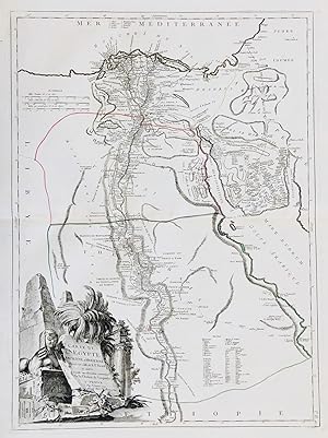
Description particuličre de l'Ancienne ÉGYPTE, histoire de ses premiers Rois jusqu'ŕ la vocation d'Abraham
Edité par Desnos, Paris, 1761
Langue: français
Carte
EUR 80
Autre deviseEUR 23,70 expédition vers FranceQuantité disponible : 1 disponible(s)
Ajouter au panierPas de couverture. Etat : Trčs bon. Description particuličre de l'Ancienne ÉGYPTE, histoire de ses premiers Rois jusqu'ŕ la vocation d'Abraham introduction ŕ l'Histoire d'ÉGYPTE USAGES, SCIENCES, arts, et Monuments de l'ÉGYPTE trois Grands documents gravés (39 cm x 55.5 cm) sur papier vergé filigrané, issu de l'Atlas BUY de MORNAS, atlas méthodique et élémentaire de Géographie, Desnos, Paris, 1761 Bon état d'usage (carte colorisée - pliure centrale verticale).
-
Cartes de l'Italie Ancienne - La Palestine ou la Terre Sainte - L'Egypte Ancienne - La Grčce ancienne.
Edité par AUBREE Armand, 1837
Vendeur : Le-Livre, SABLONS, France
Membre d'association : ILAB
Évaluation du vendeur 5 sur 5 étoiles
Carte
EUR 105
Autre deviseEUR 6 expédition vers FranceQuantité disponible : 1 disponible(s)
Ajouter au panierPas de couverture. Etat : bon. RO80039292: 1837. In-Plano. En feuillets. Etat d'usage, Livré sans Couverture, Dos satisfaisant, Fortes mouillures. 4 Cartes en double-planches, noir et blanc, hors-texte. Mouillures en marges en-tęte (32/24 cm; chaque carte). Quelques taches. . . . Classification Dewey : 912-Atlas, cartes et plans.
-

Carte de L'Egypte Ancienne et Modern. Carte de L'Egypte Ancienne et Modern Dressee sur Celle R.P. Sicard, et autres . . .
Edité par ParisRobert de Vaugondy ., 1753
Vendeur : Robert Frew Ltd. ABA ILAB, London, Royaume-Uni
Membre d'association : ABA ILAB PBFA
Évaluation du vendeur 4 sur 5 étoiles

Carte
EUR 413,50
Autre deviseEUR 7,46 expédition depuis Royaume-Uni vers FranceQuantité disponible : 1 disponible(s)
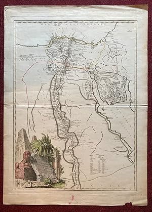
Ajouter au panierOriginal double-page engraved map of Ancient and Modern Egypt (66 x 49.5, overall sheet size 69 x 51 cm) with original outline colour and large decorative cartouche in the lower left corner. The map is based upon the reports of Father Claude Sicard (16771726), a French Jesuit priest and early modern visitor to Egypt, between 1708 and 1712. Sicard produced the earliest known map of Egypt during his time as the Supervisor of the Jesuit Mission in Cairo.
-
Carte de L'Egypte Ancienne et Moderne
Edité par Didier and Gilles Robert de Vaugondy c. 1753, Paris, 1753
Vendeur : Alexandre Antique Prints, Maps & Books, Toronto, ON, Canada
Membre d'association : ABAC ILAB
Évaluation du vendeur 5 sur 5 étoiles
Carte
EUR 600,01
Autre deviseEUR 7,34 expédition depuis Canada vers FranceQuantité disponible : 1 disponible(s)
Ajouter au panierEtat : Very Good. A beautifully detailed map of Egypt from the mid 18th century. Has a superbly decorated cartouche of Pyramids and a Sphinx by Hassard. Details everything from cities to monasteries with a special focus on the Nile and surrounding areas.A fascinating aspect of this map is the way it depicts Lake Moeris, which is now a very small lake. It also marks the famous 'Labyrinth' which had been mentioned by many authors before; such as Herodotus, Strabo, Diodorus and Pliny. It was said to have been a gigantic complex built by by Imandes for the Pharaoh Amenemhet III - filled with riches, ancient texts and ancient works of art; all priceless in their nature. There have been quite a few attempts to find this Labyrinth but, to this day, none have succeeded in their quest.Gilles Robert de Vaugondy (1688?1766), also known as Le Sieur or Monsieur Robert, and his son, Didier Robert de Vaugondy (c.1723?1786), were leading cartographers in France during the 18th century.In 1757, Gilles and Didier Robert De Vaugondy published The Atlas Universel, one of the most important atlases of the 18th century. To produce the atlas, the Vaugondys integrated older sources with more modern surveyed maps. They verified and corrected the latitude and longitude of many regional maps in the atlas with astronomical observations. The older material was revised with the addition of many new place names. In 1760, Didier Robert de Vaugondy was appointed geographer to Louis XV., Size : 642x462 (mm), 25.28x18.19 (Inches), Hand Colored, 0.
-
![Image du vendeur pour Carte de la Syrie et de l'Egypte ancienne [Syria and Ancient Egypt] mis en vente par Antiqua Print Gallery](https://pictures.abebooks.com/inventory/md/md31648440624.jpg)
Carte de la Syrie et de l'Egypte ancienne [Syria and Ancient Egypt]
Date d'édition : 1833
Vendeur : Antiqua Print Gallery, London, Royaume-Uni
Évaluation du vendeur 3 sur 5 étoiles
Carte
EUR 112,23
Autre deviseEUR 12,62 expédition depuis Royaume-Uni vers FranceQuantité disponible : 1 disponible(s)
Ajouter au panierEtat : Good. Carte de la Syrie et de l'Egypte ancienne. Syria Egypt Levant. LAPIE 1833 map. Large (folio) antique atlas map with original hand colour; Pierre Lapie, and Alexandre Emile Lapie (fils) (The publication date of the atlas within which this map was printed is stated on the title page as 1829, however the publication dates as printed on the individual maps within the volume vary from 1828 to 1836. The date of first publication of this map in the state shown is 1833 (this date is printed on the map), however the date of printing is likely to have been 1836). 63.5 x 50.0cm, 25 x 19.5 inches; this is a folding map. Condition: Good. Some of these maps have been blindstamped by the publisher as usual "Atlas Universel de Geographie (Lapie)" and the initials "EFB" of the publishers Eymery, Fruger & Brunet. There is nothing printed on the reverse side, which is plain.
-

Carte De L'Egypte Ancienne et Moderne. Dressée sur plusieurs Cartes Manuscrites, assujetie aux observations Astronomiques, Combinées avec les Ininéraires Anciens et Modernes. Par M. Bonne Hydrograph du Roi au Bureau de la Marine. Grenzkolorierte Kupferstich-Karte n. Rigobert Bonne aus "Atlas Moderne ou Collection de Cartes sur Toutes les Parties du Globe Terrestre". Paris, Jean Lattré 1762, 44 x 31 cm
Vendeur : Antiquariat Johannes Müller, Salzburg, Autriche
Membre d'association : ILAB VDAO
Évaluation du vendeur 5 sur 5 étoiles
Carte
EUR 120
Autre deviseEUR 14,50 expédition depuis Autriche vers FranceQuantité disponible : 1 disponible(s)
Ajouter au panier# Engraved map with original outline hand-colouring, wide margins, slightly brownspotted.-.
-

Egypte Ancienne.
Date d'édition : 1843
Vendeur : Geographicus Rare Antique Maps, Brooklyn, NY, Etats-Unis
Membre d'association : ABAA ESA ILAB
Évaluation du vendeur 4 sur 5 étoiles
Carte
EUR 99,56
Autre deviseEUR 38,84 expédition depuis Etats-Unis vers FranceQuantité disponible : 1 disponible(s)
Ajouter au panierVery good. Blank on verso. Size 12.5 x 9.5 Inches. This is a fine example of Conrad Malte-Brun's 1843 map of Ancient egypt, Nubia and Abyssinia, regions roughly corresponding to modern day egypt, Sudan and ethiopia. The ancient nations of Upper egypt, Lower egypt, Heptanomis, Arabia, and Judea, and Petra are included. This map illustrates egypt was under Cleopatra VII, one of the most famous women in history. Following the suicide of her lover, Mark Anthony, Cleopatra took her own life and egypt became the Roman province Aegyptus. Various cities, towns, rivers, islands and other topographical details are marked, with relief shown by hachure. Boundaries are color coded according to regions and territories. This map was issued as plate no. 12 in Conrad Malte-Brun's 1843 Precis de la Geographie Universelle .
-

EGYPT MAP c. 1762 Carte De L'Egypte Ancienne et Moderne. Dressee sur plusieurs Cartes Manuscrites, assujeties aux observations Astronomiques, Combinees avec les Itineraires Anciens et Modernes Par M. Bonne. A Paris, Chez Lattre Graveur. 1762.
Edité par Lattre c.1762, Paris, 1762
Vendeur : ANTIQUARIAT.WIEN Fine Books & Prints, Wien, Autriche
Membre d'association : ILAB VDAO
Évaluation du vendeur 5 sur 5 étoiles
Carte
EUR 137,50
Autre deviseEUR 23,90 expédition depuis Autriche vers FranceQuantité disponible : 1 disponible(s)
Ajouter au paniermap, original Kupferstich handkoloriert, original copperengraving, hand-coloured, image size approximately 41 x 29 cm old Antique Print / originale Druckgrafik fr 500 Landkarte.
-

EGYPT ANCIENT EGYPT MAP/ ÄGYPTEN, ANTIKE LANDKARTE /, DELAMARCHE 1838 ; Titel: Carte de l'Egypte ancienne, Par Delamarche 1838.
Edité par Delamarche, [Paris], 1838
Vendeur : ANTIQUARIAT.WIEN Fine Books & Prints, Wien, Autriche
Membre d'association : ILAB VDAO
Évaluation du vendeur 5 sur 5 étoiles
Carte
EUR 170,50
Autre deviseEUR 23,90 expédition depuis Autriche vers FranceQuantité disponible : 1 disponible(s)
Ajouter au panieroriginal map, old colours, original Landkarte, altkoloriert , Blatt ca. 47 x 34 cm ORIGINAL MAP /ORIGINALE LANDKARTE de 500 Landkarte.
-

Carte de l'Egypte Ancienne et Moderne (.)
Edité par Jean Lattré, 1762
Vendeur : Antiquariaat Dat Narrenschip, Middelburg, Pays-Bas
Membre d'association : ILAB NVVA
Évaluation du vendeur 5 sur 5 étoiles
Carte
EUR 180
Autre deviseEUR 16 expédition depuis Pays-Bas vers FranceQuantité disponible : 1 disponible(s)
Ajouter au panierNo Binding. Etat : Fine. Antique map of Egypt. Title cartouche with the name of the cartographer (Rigobert Bonne) top right. The publisher's imprint at the bottom of this cartouche. Scale sticks top left. Hand-coloured copper engraving, published in Paris in 1762 by Jean Lattré in "Atlas Moderne ou Collection de Cartes sur Toutes les Parties du Globe Terrestre." Dimensions (image): 32 x 44 cm.
-

Kupferstich- Karte, v. Haussard n. R.P. Sicard b. Rob. de Vaugondy, "Carte de L'Egypte ancienne et Moderne".
Langue: allemand
Vendeur : Antiquariat Clemens Paulusch GmbH, Berlin, Allemagne
Membre d'association : ILAB VDA
Évaluation du vendeur 5 sur 5 étoiles
Carte
EUR 240
Autre deviseEUR 15 expédition depuis Allemagne vers FranceQuantité disponible : 1 disponible(s)
Ajouter au paniermit altem Grenzkolorit, dat. 1753, 64 x 46 (H) Unten links die dek. Titelkartusche ( geschmückt mit Pyramiden ).
-

Kupferstich- Karte, n. Sicard u. Robert Vaugondy b. Santini u. Remondini, "Carte de L'Egypte Ancienne et Moderne.".
Langue: allemand
Vendeur : Antiquariat Clemens Paulusch GmbH, Berlin, Allemagne
Membre d'association : ILAB VDA
Évaluation du vendeur 5 sur 5 étoiles
Carte
EUR 250
Autre deviseEUR 15 expédition depuis Allemagne vers FranceQuantité disponible : 1 disponible(s)
Ajouter au paniermit altem Grenzkolorit, dat. 1779, 62,5 x 46 (H) Zweiter Zustand mit zusätzlicher Nennung des Verlegers Remondini. Zeigt Ägypten zwischen der Insel Philae. Unten links dekorative Titelkartusche.
-
CARTE DE L'EGYPTE ANCIENNE ET MODERNE, DRESSEE SUR CETTE DU R. P. SICKARD ET AUTRES.
Date d'édition : 1753
Vendeur : Graham York Rare Books ABA ILAB, Honiton, Royaume-Uni
Membre d'association : ABA ILAB PBFA
Évaluation du vendeur 5 sur 5 étoiles
Carte
EUR 354,42
Autre deviseEUR 13,94 expédition depuis Royaume-Uni vers FranceQuantité disponible : 1 disponible(s)
Ajouter au panierCirca 1753, size 535mm x 745mm, hand coloured, engraved cartouche by Haussard, featuring a sphinx, pyramids, ruins and palm trees. A little worn in the margins, otherwise very good.


![Image du vendeur pour Egypte Ancienne [Ancient Egypt] mis en vente par Antiqua Print Gallery](https://pictures.abebooks.com/inventory/md/md31102248713.jpg)
![Image du vendeur pour Original Map. Egypte Ancienne. [Ancient Egypt] mis en vente par Roz Hulse](https://pictures.abebooks.com/inventory/md/md32230516322.jpg)