
Montant total (1 article articles) :
Destination de la commande :

hydrographical chart world wright mercators (2 rťsultats)
Passer aux rťsultats principaux de la recherche
Filtres de recherche
Type d'article
- Tous les types de produits
- Livres (2)
- Magazines & Pťriodiques (Aucun autre rťsultat ne correspond ŗ ces critŤres)
- Bandes dessinťes (Aucun autre rťsultat ne correspond ŗ ces critŤres)
- Partitions de musique (Aucun autre rťsultat ne correspond ŗ ces critŤres)
- Art, Affiches et Gravures (Aucun autre rťsultat ne correspond ŗ ces critŤres)
- Photographies (Aucun autre rťsultat ne correspond ŗ ces critŤres)
- Cartes (Aucun autre rťsultat ne correspond ŗ ces critŤres)
- Manuscrits & Papiers anciens (Aucun autre rťsultat ne correspond ŗ ces critŤres)
Etat En savoir plus
- Neuf (Aucun autre rťsultat ne correspond ŗ ces critŤres)
- Comme neuf, TrŤs bon ou Bon (Aucun autre rťsultat ne correspond ŗ ces critŤres)
- Assez bon ou satisfaisant (1)
- Moyen ou mauvais (Aucun autre rťsultat ne correspond ŗ ces critŤres)
- Conformťment ŗ la description (1)
Reliure
- Toutes
- Couverture rigide (Aucun autre rťsultat ne correspond ŗ ces critŤres)
- Couverture souple (Aucun autre rťsultat ne correspond ŗ ces critŤres)
Particularitťs
- Ed. originale (1)
- Signť (Aucun autre rťsultat ne correspond ŗ ces critŤres)
- Jaquette (Aucun autre rťsultat ne correspond ŗ ces critŤres)
- Avec images (2)
- Sans impressions ŗ la demande (2)
Langue (1)
Prix
- Tous les prix
- Moins de EUR 20 (Aucun autre rťsultat ne correspond ŗ ces critŤres)
- EUR 20 ŗ EUR 40 (Aucun autre rťsultat ne correspond ŗ ces critŤres)
- Plus de EUR 40
Livraison gratuite
- Livraison gratuite ŗ destination de Etats-Unis (Aucun autre rťsultat ne correspond ŗ ces critŤres)
Pays
Evaluation du vendeur
-

Hydrographical Chart Of The World On Wright Or Mercators Projection With Tracks Of The Last Circumnavigators From 'A New General Atlas, consisting of A Series of Geographical Designs, on Various Projections, Exhibiting the Form and Component Parts of the Globe; and A Collection of Maps and Charts, Delineating the Natural and Political Divisions of the Empires, Kingdoms and States of the World'.
Editť par John Thomson & Company, Edinburgh, UK, 1814
Vendeur : Hornseys, Ripon, Royaume-Uni
Membre d'association : PBFA
…valuation du vendeur 5 sur 5 ťtoiles

EUR 347,84
Expťdition ŗ†EUR 28,62
Expťdition depuis Royaume-Uni vers Etats-UnisQuantitť disponible : 1 disponible(s)
Ajouter au panierNo Binding. Etat : Very Good. Sheet size: 68cm x 53.8cm. From 'A New General Atlas, consisting of A Series of Geographical Designs, on Various Projections, Exhibiting the Form and Component Parts of the Globe; and A Collection of Maps and Charts, Delineating the Natural and Political Divisions of the Empires, Kingdoms and States of the World'. Date c.1814-1816. Crease to central fold line with a short split to the margin. Blank to the reverse. Age-toning, especially to the margins, minor off-setting and slight foxing as usual. Original hand-colouring nice and bright. In very good, bright, clean condition. This is one of a number of these maps that e are currently posting. Please see our other listings or use the keyword: hornseysthomson.
-
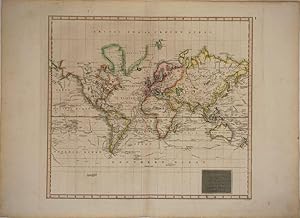
Hydrographical Chart of the World on Wright or Mercators Projection with Tracks of the Last Circumnavigators
Date d'ťdition : 1814
Vendeur : Antipodean Books, Maps & Prints, ABAA, Garrison, NY, Etats-Unis
Membre d'association : ABAA ANZAAB ESA ILAB
…valuation du vendeur 5 sur 5 ťtoiles
Edition originale
EUR 432,49
Expťdition ŗ†EUR 7,63
Expťdition nationale†: Etats-UnisQuantitť disponible : 1 disponible(s)
Ajouter au panierAn excellent example of John Thomson's 1814 map of the world on Mercator's projection. Published in the 1814 edition of Thomson's General Atlas, this map was drawn to illustrate the great voyages of discovery of the late 18th century, most specifically Cook, Perouse, and Vancouver. Exploratory routes zigzag through the oceans and seas of this map, showing important land marks on the various voyages illustrated. The map identifies Cook's death in Hawaii, Vancouver's exploration of the Nootka Sound, and Perouse's navigations in Alaska. The routes of Phips around Spitzbergen and Pickersgill in the Baffin Bay are also delineated. The vastly important inland expeditions of Mackenzie (1789) and Hearne (1771) through the interior of North America are also noted. The Northwest Coast of America is still largely inaccurate, and the NW Passage has not been charted. No sign of the Antarctic coast, with Cook's travels being the farthest noted in the south.This is the first edition of Thomson's map from the 1814 edition of the General Atlas. Subsequent editions of Thomson's General Atlas were published in 1817 and 1826. 18 x 20 1/2 in.