
Montant total (1 article articles) :
Destination de la commande :

map new hampshire vermont de thomas cowperthwait (3 rťsultats)
Commentaires
Passer aux rťsultats principaux de la recherche
Filtres de recherche
Type d'article
- Tous les types de produits
- Livres (2)
- Magazines & Pťriodiques (Aucun autre rťsultat ne correspond ŗ ces critŤres)
- Bandes dessinťes (Aucun autre rťsultat ne correspond ŗ ces critŤres)
- Partitions de musique (Aucun autre rťsultat ne correspond ŗ ces critŤres)
- Art, Affiches et Gravures (Aucun autre rťsultat ne correspond ŗ ces critŤres)
- Photographies (Aucun autre rťsultat ne correspond ŗ ces critŤres)
- Cartes (1)
- Manuscrits & Papiers anciens (Aucun autre rťsultat ne correspond ŗ ces critŤres)
Etat En savoir plus
- Neuf (Aucun autre rťsultat ne correspond ŗ ces critŤres)
- Comme neuf, TrŤs bon ou Bon (Aucun autre rťsultat ne correspond ŗ ces critŤres)
- Assez bon ou satisfaisant (2)
- Moyen ou mauvais (Aucun autre rťsultat ne correspond ŗ ces critŤres)
- Conformťment ŗ la description (1)
Reliure
- Toutes
- Couverture rigide (Aucun autre rťsultat ne correspond ŗ ces critŤres)
- Couverture souple (Aucun autre rťsultat ne correspond ŗ ces critŤres)
Particularitťs
- Ed. originale (1)
- Signť (Aucun autre rťsultat ne correspond ŗ ces critŤres)
- Jaquette (Aucun autre rťsultat ne correspond ŗ ces critŤres)
- Avec images (3)
- Sans impressions ŗ la demande (3)
Langue (1)
Prix
- Tous les prix
- Moins de EUR 20 (Aucun autre rťsultat ne correspond ŗ ces critŤres)
- EUR 20 ŗ EUR 45
- Plus de EUR 45
Livraison gratuite
- Livraison gratuite ŗ destination de France (Aucun autre rťsultat ne correspond ŗ ces critŤres)
Pays
Evaluation du vendeur
-
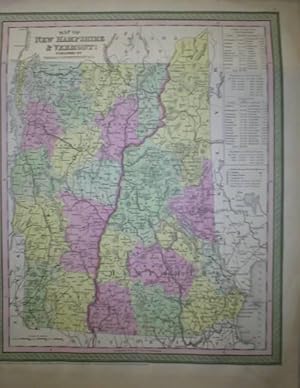
Map of New Hampshire & Vermont
Editť par Thomas Cowperthwait & Co., Philadelphia, 1850
Vendeur : Vashon Island Books, Vashon, WA, Etats-Unis
…valuation du vendeur 5 sur 5 ťtoiles

Edition originale
EUR 39,53
Autre deviseEUR 28,10 expťdition depuis Etats-Unis vers FranceQuantitť disponible : 1 disponible(s)
Ajouter au panierSingle Sheet. Etat : Very Good. Hand-colored map. (illustrateur). First Thus. VG (sl. discoloration to margins) Folio sheet; Hand-colored (4 colors) map from 1850. Image size 15.5" x 12.5", sheet size 17" x 13.5". Size: Folio - over 12" - 15" tall. Book.
-
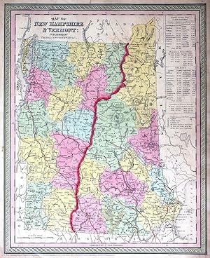
Map of New Hampshire and Vermont
Editť par Thomas, Cowperthwait & Co., Philadelphia, 1850
Vendeur : Antipodean Books, Maps & Prints, ABAA, Garrison, NY, Etats-Unis
Membre d'association : ABAA ANZAAB ESA ILAB
…valuation du vendeur 5 sur 5 ťtoiles
EUR 121,22
Autre deviseEUR 30,49 expťdition depuis Etats-Unis vers FranceQuantitť disponible : 1 disponible(s)
Ajouter au panierMaps. Etat : Very good overall. Map of New Hampshire and Vermont, with counties marked, travel information (distances, railroads, steamboat routes in states served by them, population, canals, capitals, county towns, etc.) Approx. 12 1/2 x15 1/2". From the "New Universal Atlas containing Maps of the various Empires, Kingdoms, States and Republics of the World with a special map of each of the United States Plans of Cities & c." Chromolithographs with printed color. A little tanned, edges a little ruffled, o/w minor faults generally in the margins.
-
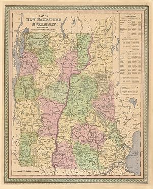
Map of New Hampshire & Vermont
Date d'ťdition : 1852
Vendeur : Antiqua Print Gallery, London, Royaume-Uni
…valuation du vendeur 3 sur 5 ťtoiles

Carte
EUR 95,24
Autre deviseEUR 12,71 expťdition depuis Royaume-Uni vers FranceQuantitť disponible : 1 disponible(s)
Ajouter au panierEtat : Good. Map of New Hampshire & Vermont. State map with counties. COWPERTHWAIT 1852. Decorative antique hand coloured map; Thomas, Cowperthwait & Co (1852). 40.0 x 32.5cm, 15.75 x 12.75 inches. Condition: Good. There is nothing printed on the reverse side, which is plain.