
Montant total (1 article articles) :
Destination de la commande :

nova orbis tabula de de wit (8 résultats)
Commentaires
Passer aux résultats principaux de la recherche
Filtres de recherche
Type d'article
- Tous les types de produits
- Livres (1)
- Magazines & Périodiques (Aucun autre résultat ne correspond ŕ ces critčres)
- Bandes dessinées (Aucun autre résultat ne correspond ŕ ces critčres)
- Partitions de musique (Aucun autre résultat ne correspond ŕ ces critčres)
- Art, Affiches et Gravures (1)
- Photographies (Aucun autre résultat ne correspond ŕ ces critčres)
- Cartes (6)
- Manuscrits & Papiers anciens (Aucun autre résultat ne correspond ŕ ces critčres)
Etat En savoir plus
- Neuf (Aucun autre résultat ne correspond ŕ ces critčres)
- Comme neuf, Trčs bon ou Bon (1)
- Assez bon ou satisfaisant (Aucun autre résultat ne correspond ŕ ces critčres)
- Moyen ou mauvais (Aucun autre résultat ne correspond ŕ ces critčres)
- Conformément ŕ la description (7)
Reliure
- Toutes
- Couverture rigide (Aucun autre résultat ne correspond ŕ ces critčres)
- Couverture souple (Aucun autre résultat ne correspond ŕ ces critčres)
Particularités
- Ed. originale (3)
- Signé (Aucun autre résultat ne correspond ŕ ces critčres)
- Jaquette (Aucun autre résultat ne correspond ŕ ces critčres)
- Avec images (7)
- Sans impressions ŕ la demande (8)
Langue (1)
Prix
- Tous les prix
- Moins de EUR 20 (Aucun autre résultat ne correspond ŕ ces critčres)
- EUR 20 ŕ EUR 45 (Aucun autre résultat ne correspond ŕ ces critčres)
- Plus de EUR 45
Livraison gratuite
- Livraison gratuite ŕ destination de Etats-Unis (Aucun autre résultat ne correspond ŕ ces critčres)
Pays
Evaluation du vendeur
-

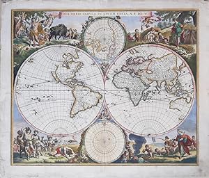
Nova Orbis Tabula In Lucem Edita
Edité par Amsterdam, 1670
Vendeur : libreria antiquaria perini Sas di Perini, Verona, VR, Italie
Membre d'association : ALAI ILAB
Évaluation du vendeur 5 sur 5 étoiles

Art / Affiche / Gravure
EUR 7 000
Autre deviseEUR 40 expédition depuis Italie vers Etats-UnisQuantité disponible : 1 disponible(s)
Ajouter au panierIncisione in rame, mm 464 x 546, dipinta a mano díepoca. Primo stato su due, senza cherubini nelle cuspidi, a cui seguir? nel 1680 una nuova lastra con cornice e con numerosi aggiornamenti geografici delle nuove scoperte nel Pacifico e dellíinterno del continente americano. In questo primo stato compaiono la California come isola secondo il prototipo di Briggs (che sar? poi sostituita dal modello sansoniano) e Anian con lo stretto nella costa nord-ovest del continente americano. Nel Pacifico non compare ancora la Nova Guinea nellíemisfero occidentale. Bellissimo esemplare con minimi restauri alla piegatura centrale in basso.Uno fra i pi? decorativi mappamondi olandesi seicenteschi. Shirley, R.W. The Mapping of the World pag. 468: ěIl mappamondo di De Wit Ë uno dei pi? attraenti dellíepoca. Le brillanti scene agli angoli combinano le immagini delle quattro stagioni, degli elementi e dei segni zodiacali in modo equilibrato e naturalisticoî.De Wit (1629 c. -1706) fu un cartografo e commerciante di mappe nato a Gouda, che lavorÚ e morĎ ad Amsterdam. Si trasferĎ in citt? nel 1648, dove aprĎ uníattivit? di stampa. A partire dagli anni í60 Ë noto soprattutto per atlanti e piante di citt? olandesi. Dopo la morte di Frederic nel 1706, la moglie Maria gestĎ il negozio per quattro anni prima di venderlo poichČ il figlio Franciscus non aveva alcun interesse per il negozio di mappe. La maggior parte delle tavole andÚ a Pieter Mortier, la cui ditta divenne Covens & Mortier, una delle pi? grandi case cartografiche del XVIII secolo.Bibliografia: Shirley 451Copper engraving, 464 x 546 mm, original colour. First state of two, without cherubs in the cusps, to be followed in 1680 by a new plate with frame and with numerous geographical updates of the new discoveries in the Pacific and the interior of the American continent. In this first state appear California as an island according to Briggsí prototype (later to be replaced by the Sansonian model) and Anian with the strait on the northwest coast of the American continent. Nova Guinea does not yet appear in the Pacific in the western hemisphere. Beautiful example with minimal restorations to the central fold at the bottom.One of the most decorative 17th century Dutch globes. Shirley, R.W. The Mapping of the World p. 468: ëDe Witís globe is one of the most attractive of the period. The brilliant scenes in the corners combine the images of the four seasons, the elements and the signs of the zodiac in a balanced and naturalistic mannerí. De Wit (c. 1629 -1706) was a cartographer and map dealer born in Gouda, who worked and died in Amsterdam. From the 1660s onwards, he is best known for atlases and plans of Dutch cities. After his death, most of the plates went to Pieter Mortier, whose firm became Covens & Mortier, one of the largest map houses of the 18th century. Bibliography: Shirley 451 Nr.cat: Cod 8200.
-

Nova Orbis Tabula, in Lucem Edita, A. F. De Wit
Edité par Amsterdam, 1670
Vendeur : Clive A. Burden Ltd., Chalfont St. Giles, BUCKS, Royaume-Uni
Membre d'association : ABA ILAB
Évaluation du vendeur 2 sur 5 étoiles

Carte
EUR 6 496,84
Autre deviseEUR 25,40 expédition depuis Royaume-Uni vers Etats-UnisQuantité disponible : 1 disponible(s)
Ajouter au panierNo binding. 480 x 570 mm., in fine early wash colour, remnants of mounting tape to the verso, otherwise in good condition. 'De Wit's map is one of the most attractive of its time' (Shirley). Accurate dating of the publication of Frederick de Wit's double-hemisphere world map is not possible as his atlases are undated and we have no further concrete knowledge. Shirley suggests that based on the cartographic depictions of Hudson's Bay that this map might even pre-date his maritime world map of 1668. De Wit (1630-1706) was one of the most successful Dutch engravers and map publishers of the second half of the seventeenth century. He had already published three wall maps of the world by 1670, in twelve, four and eight sheets. This attractive double-hemisphere map is renowned for its decoration. It bears two polar projection insets top and bottom and the surrounds are filled with allegorical designs incorporating the four elements, four seasons and the signs of the zodiac. This second state bears cherubs in the cusps between the hemispheres. The map was included in the composite de Wit atlases of the period and can also be found in those of other rival Dutch publishers such as Nicolas Visscher, the heirs of Jansson. A good clean example of a classic Dutch piece of cartographic art which was much copied by later cartographers. Provenance: private English collection since 1985. Koeman (1967-70) Wit 1; Shirley (1984) 451 st. 2.
-

Nova Orbis Tabula, in lucem edita, A.F. De Wit
Edité par Amsterdam 1670 ca., 1670
Vendeur : Libreria Ex Libris ALAI-ILAB/LILA member, Roma, RM, Italie
Membre d'association : ALAI ILAB
Évaluation du vendeur 5 sur 5 étoiles
Carte
EUR 6 500
Autre deviseEUR 30 expédition depuis Italie vers Etats-UnisQuantité disponible : 1 disponible(s)
Ajouter au panierCarta geografica originale (cm. 56x47,5 piů ampi margini bianchi). Splendida coloritura coeva all'acquarello. Due minuscoli fori con antico rinforzo al verso e alcune lievi macchie marginali ma nel complesso esemplare in ottimo stato di conservazione ed assai genuino. Secondo stato, con la presenza dei putti nelle cuspidi e con l'aggiunta della cornice esterna. Uno dei piů importanti e fascinosi mappamondi a doppio emisfero del XVII Secolo. Le brillanti scene angolari mostrano le rappresentazioni delle stagioni con i relativi segni zodiacali ed i quattro elementi. La carta comprende inoltre le due proiezioni polari incorniciate da ghirlande floreali e coppie di amorini. Cfr. Shirley,'The mapping of the world', n. 451.
-
NOVA ORBIS TABULA IN LUCEM EDITA A.F. DE WIT
Edité par 1700 ca., 1700
Vendeur : LUX IN ART di Ermanno Bertelli, Bologna, BOLOG, Italie
Évaluation du vendeur 4 sur 5 étoiles

Carte
EUR 4 500
Autre deviseEUR 42 expédition depuis Italie vers Etats-UnisQuantité disponible : 1 disponible(s)
Ajouter au panierEtat : ottimo. Incisione in rame. Spettacolare tavola rappresentante i globi terrestri del cartografo fiammingo Federick De Wit (1630-1703). Nella tavola sono rappresentate quattro scene allegoriche rappresentanti le quattro stagioni in alto e in basso a destra ed a sinistra. Bella coloritura d'epoca, ottimo stato di conservazione. Formato: 475x565mm (piů margine).
-

Nova Orbis Tabula in Lucem Edita, A.F. de Wit. Map Monde.
Edité par Amsterdam. c1680, Second state., 1680
Vendeur : Peter Harrington. ABA/ ILAB., London, Royaume-Uni
Membre d'association : ABA ILAB PBFA
Évaluation du vendeur 5 sur 5 étoiles
EUR 8 741,20
Autre deviseEUR 16,06 expédition depuis Royaume-Uni vers Etats-UnisQuantité disponible : 1 disponible(s)
Ajouter au panierA very beautiful and ornate world map. "De Wit's map is one of the most attractive of its time. The brilliant scenes in the corners combine images of the four seasons, the elements, and the signs of the zodiac in a well-balanced and naturalistic way." Shirley, R.W. The Mapping of the World page 468. This is state two with the cherubs in the cusps. There are two inset hemispherical maps showing polar projections. Shirley, R.W. "The Mapping of the World" Entry 451. Copper engraving. Size: 56.2 x 48 cm. (22 x 19 inches). Framed size 85 x 77cm Original colour. Good margins. Centrefold strengthened. Expert repair to worm hole on lower right margin, a little darkened and some spotting mainly on margins, very good condition.
-

Nova Orbis Tabula, in Lucem.
Edité par Amsterdam, 1689
Vendeur : Alexandre Antique Prints, Maps & Books, Toronto, ON, Canada
Membre d'association : ABAC ILAB
Évaluation du vendeur 5 sur 5 étoiles
Carte Edition originale
EUR 6 576,48
Autre deviseEUR 5,11 expédition depuis Canada vers Etats-UnisQuantité disponible : 1 disponible(s)
Ajouter au panierSecond edition plate."De Wits's map is one of the most attractive of its time. The brilliant scenes in the corners combine images of the four seasons, the elements, and the signs of the zodiac in a well-balanced and naturalistic way. . . There was a second plate in c.1680 which can be distinguished by the appearance of 'Nova Guinea' and 'Quiri Regio' on the left-hand hemisphere." (Shirley)Other changes in the second edition include the deletion of the strait of Anian present in the first edition (north of the island of California), greater detail in the North American continent (inclusion of Great Lakes and names around Hudson's Bay), and an updated north polar projection. The Great Lakes are based on Sanson's model., Size : 480x570 (mm), 18.875x22.375 (Inches), Original Hand Coloring, 0 Very Good, some oxidation of the green pigment. Laid on acid free tissue paper for long term preservation.
-
Nova Orbis Tabula In Lucem Edita, A. F. de Wit.
Date d'édition : 1665
Vendeur : Geographicus Rare Antique Maps, Brooklyn, NY, Etats-Unis
Membre d'association : ABAA ESA ILAB
Évaluation du vendeur 4 sur 5 étoiles
Carte Edition originale
EUR 5 892,52
Autre deviseEUR 14,47 expédition vers Etats-UnisQuantité disponible : 1 disponible(s)
Ajouter au panierExcellent. Reinforced in some areas to stabilized oxidizing color; else fine with original color. Size 18.25 x 21.5 Inches. This is a striking c. 1689 example, in original color, of Frederick De Wit's classic double hemisphere map of the world. Shirley praised it as 'one of the most attractive of its time' . It features many of the tropes of 17th-century Dutch mapmaking: Insular California, imaginary islands, etc., as well as new discoveries, such as Western Australia, and cartographic reconsiderations, among them the removal of the imaginary Terra Australis . A Closer Look De Wit's map presents the state of the art of Dutch mapmaking as expressed in Nicolas Visscher's 1658 map of the world, its detail drawn primarily from Joan Blaeu's Nova et Accuratissima Totius Terrarum Orbis Tabula . In both its geographical detail and the composition of its primary and subordinate hemispheres, it references Visscher. Dating Shirley tentatively dated the first issue of this map at c. 1670, but its content - particularly compared with De Wit's other world maps - suggests it was engraved earlier, although not before 1660, as it was intended as an update to the mapmaker's 1660 world map (Shirley 421). Despite Shirley's date, it thus seems reasonable to assign it a date earlier than 1668. De Wit's map of that year exhibited geographical details that do not appear here, and it is unlikely that such improvements would be lightly abandoned. Once published, the map remained in De Wit's atlases with no cartographic changes. The South As was typical in the second half of the 17th century, De Wit dispenses with the Terra Australis Incognita that dominated the South Pole of earlier maps, but which mariners consistently failed to find. The south polar projection is starkly empty, apart from a portion of Patagonia and a full-coastlined Tierra del Fuego. The oft-imagined southern continent is replaced in the primary hemispheres by the inclusion of Abel Tasman's discoveries of Australia and New Zealand's western coastlines in 1642 and 1644. The North The guesswork and legend that informed the 16th-century mapping of the North have been replaced with the concrete results of exploration. Mercator's four Arctic landmasses are gone, as is the fraudulent Zeno cartography, which dominated the mapping of the North Atlantic in the first part of the 17th century. Greenland is mapped with the Davis Strait, and James' Bay is recognizably charted. The efforts of Dutch whalers are recorded in the mapping of Spitzbergen. Nova Zembla appears as an island, although its eastern shore is not yet charted. The northeastern extremes of Asia are still ill-formed, awaiting the efforts of Witsen and other mapmakers of the late 17th century. Buss Island Although Zeno's Frisland, Icaria, and Estotiland have been removed, in the north polar projection, another phantom island - Buss Island - has been added. Sailors on the 1578 third expedition of Martin Frobisher, navigating on the ship Emanuel (a class of ship known as a busse ), recorded the sighting of an island in the ocean between Ireland and Zeno's fraudulent Frisland. It is thought that Frobisher's Frisland was actually southern Greenland, that what he thought was Greenland was Baffin Island, and that the location of the newly discovered Buss Island was in the wrong place (57°N rather than probably 62°N) and was furthermore an optical effect, rather than actual land. Despite this, in 1671, Thomas Shepard claimed that not only was the island real, but they also explored and mapped it. In 1745, it was proposed that the island was real but had sunk. In 1818, its existence was disproved by John Ross, who, during his first Arctic expedition, plumbed the waters of its alleged location to a depth of 180 fathoms (330 m), finding no bottom. North America The east coast of North America is increasingly more recognizable. Cape Cod is recognizable, Virginia is named, and the barrier islands of the Carolinas are discernable. The interior is virtually unknown, although this is among the earliest world maps to have a large, distinct lake associated with the St. Lawrence River, albeit with no western shore. De Wit's use of the Blaeu cartography for the Great Lakes, in particular, gives us reason to suggest a date for this map before De Wit's 1668 world map, which shows the Great Lakes modeled after Nicolas Sanson's map of 1660. (The 1668 map's Australia and New Zealand also closely resemble Sanson.) New Mexico's Rio del Norte is conflated with the Colorado River, petering out to the west rather than emptying into the Gulf of Mexico. De Wit's map includes a prominent insular California, expressing an accepted geographical truth of the day. The Pacific coastline is incomplete, leaving hope for a northwest passage connecting to Hudson's Bay. Notably, the north Pacific - from De Vries' Compagnie's Landt in the west to Anian in the east - is empty, revealing the lack of data in eloquent silence. A Lively and Beautiful Engraving If Visscher's 1658 map established a new standard for the decoration of maps, De Wit appears to have been equal to the challenge. As derivative as his geography may have been, the artistry of his borders and their themes were fresh and playful. While Visscher's decorative scenes depict the elements, De Wit's lively vignettes depict the seasons and cleverly insert seasonal Zodiacal symbols. Spring, for example, surrounds Venus and Cupid with a horde of putti wrangling a garlanded bull and a stubborn ram. Winter features the titular Old Man of the season. With him, the ubiquitous pudgy angels wrestle Capricorn's goat, while another displays a pair of fish (Pisces), and another fills a basin of water (Aquarius). Autumn features a riotous band of satyrs. They carry one drinker aloft while another, defeated by his wine, suffers the inevitable result of his excess sprawled on the grass. A Sagittarian centaur hunts in the background. In the crowd of putti attending the bacchanalia, one ca.
-

Nova Orbis Tabula In Lucem Edita, A. F. de Wit.
Date d'édition : 1665
Vendeur : Geographicus Rare Antique Maps, Brooklyn, NY, Etats-Unis
Membre d'association : ABAA ESA ILAB
Évaluation du vendeur 4 sur 5 étoiles
Carte Edition originale
EUR 5 401,48
Autre deviseEUR 14,47 expédition vers Etats-UnisQuantité disponible : 1 disponible(s)
Ajouter au panierGood. Original color oxidized leading to cracking in some areas with some areas of loss; neatly mended centerfold split at bottom. Else a lovely copy with an attractive patina. Size 18.25 x 21.5 Inches. This is a striking c. 1689 example, in original color, of Frederick De Wit's classic double hemisphere map of the world. Shirley praised it as 'one of the most attractive of its time' . It features many of the tropes of 17th-century Dutch mapmaking: Isular California, imaginary islands, etc., as well as new discoveries, such as Western Australia, and cartographic reconsiderations, among them the removal of the imaginary Terra Australis . A Closer Look De Wit's map presents the state of the art of Dutch mapmaking as expressed in Nicolas Visscher's 1658 map of the world, its detail drawn primarily from Joan Blaeu's Nova et Accuratissima Totius Terrarum Orbis Tabula . In both its geographical detail and the composition of its primary and subordinate hemispheres, it references Visscher. Dating Shirley tentatively dated the first issue of this map at c. 1670. However, its content (particularly compared with De Wit's other world maps) suggests it was engraved earlier, although not before 1660, as it was intended as an update to the mapmaker's 1660 world map (Shirley 421). Despite Shirley's date, it thus seems reasonable to assign it a date earlier than 1668. De Wit's map of that year exhibited geographical details that do not appear here, and it is unlikely that such improvements would be lightly abandoned. Once published, the map remained in De Wit's atlases with no cartographic changes. The South As was typical in the second half of the 17th century, De Wit dispenses with the Terra Australis Incognita that dominated the South Pole of earlier maps, but which mariners consistently failed to find. The south polar projection is starkly empty, apart from a portion of Patagonia and a full-coastlined Tierra del Fuego. The oft-imagined southern continent is replaced in the primary hemispheres by the inclusion of Abel Tasman's discoveries of Australia and New Zealand's western coastlines in 1642 and 1644. The North The guesswork and legend that informed the 16th-century mapping of the North have been replaced with the concrete results of exploration. Mercator's four Arctic landmasses are gone, as is the fraudulent Zeno cartography, which dominated the mapping of the North Atlantic in the first part of the 17th century. Greenland is mapped with the Davis Strait, and James' Bay is recognizably charted. The efforts of Dutch whalers are recorded in the mapping of Spitzbergen. Nova Zembla appears as an island, although its eastern shore is not yet charted. The northeastern extremes of Asia are still ill-formed, awaiting the efforts of Witsen and other mapmakers of the late 17th century. Buss Island Although Zeno's Frisland, Icaria, and Estotiland have been removed, in the north polar projection, another phantom island - Buss Island - has been added. Sailors on the 1578 third expedition of Martin Frobisher, navigating on the ship Emanuel (a class of ship known as a busse ) recorded the sighting of an island in the ocean between Ireland and Zeno's fraudulent Frisland. It is thought that Frobisher's Frisland was actually southern Greenland, that what he thought was Greenland was Baffin Island, and that the location of the newly discovered Buss Island was in the wrong place (57°N rather than probably 62°N) and was furthermore an optical effect, rather than actual land. Despite this, in 1671, Thomas Shepard claimed that not only was the island real, but they also explored and mapped it. In 1745, it was proposed that the island was real but had sunk. In 1818, its existence was disproved by John Ross, who, during his first Arctic expedition, plumbed the waters of its alleged location to a depth of 180 fathoms (330 m), finding no bottom. North America The east coast of North America is increasingly more recognizable. Cape Cod is recognizable, Virginia is named, and the barrier islands of the Carolinas are discernable. The interior is virtually unknown, although this is among the earliest world maps to have a large, distinct lake associated with the St. Lawrence River, albeit with no western shore. De Wit's use of the Blaeu cartography for the Great Lakes, in particular, gives us reason to suggest a date for this map before De Wit's 1668 world map, which shows the Great Lakes modeled after Nicolas Sanson's map of 1660. (The 1668 map's Australia and New Zealand also closely resemble that of the Sanson.) New Mexico's Rio del Norte is conflated with the Colorado River, petering out to the west rather than emptying into the Gulf of Mexico. De Wit's map includes a prominent insular California, expressing an accepted geographical truth of the day. The Pacific coastline is incomplete, leaving hope for a northwest passage connecting to Hudson's Bay. Notably, the north Pacific - from De Vries' Compagnie's Landt in the west to Anian in the east - is empty, revealing the lack of data in eloquent silence. A Lively and Beautiful Engraving If Visscher's 1658 map established a new standard for the decoration of maps, De Wit appears to have been equal to the challenge. As derivative as his geography may have been, the artistry of his borders and their themes were fresh and playful. While Visscher's decorative scenes depict the elements, De Wit's lively vignettes depict the seasons and cleverly insert seasonal Zodiacal symbols. Spring, for example, surrounds Venus and Cupid with a horde of putti wrangling a garlanded bull and a stubborn ram. Winter features the titular Old Man of the season. With him, the ubiquitous pudgy angels wrestle Capricorn's goat, while another displays a pair of fish (Pisces), and another fills a basin of water (Aquarius). Autumn features a riotous band of satyrs. They carry one drinker aloft while another, defeated by his wine, suffers the inevitable result of his excess sprawled on the grass. A Sagittar.

